James Hammett
EF4
I've been chasing with the OsmAnd app using OpenStreetMap (OSM) data for a few years now and it's a game changer. For me there's a couple of great features in particular:
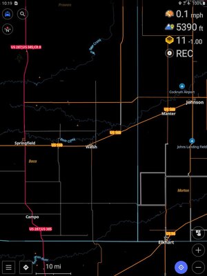
I've been using my own custom rendering style and it's working great. Easy to differentiate between expressways, paved secondaries, Bob's Road, etc. And the bright colors are easy to see in sunlight on my OLED tablet.
Check out and download my custom rendering style optimized for storm chasing here: GitHub - pqo/stormchasing-rendering-style: An OsmAnd rendering style optimized for storm chasing!
The OsmAnd app (Android, iOS) uses offline data you save to the device in advance by simply selecting which states to download. I update mine at the start of each season and do smaller live updates on a per-chase basis. So it doesn't depend on internet access at all.
- Ability to edit the underlying OSM data to make corrections when necessary -- especially important for road surface integrity
- Ability to use a custom map rendering style to instantly differentiate road types (e.g., poor gravel vs. paved highway) for safe and efficient navigation
I've been using my own custom rendering style and it's working great. Easy to differentiate between expressways, paved secondaries, Bob's Road, etc. And the bright colors are easy to see in sunlight on my OLED tablet.
Check out and download my custom rendering style optimized for storm chasing here: GitHub - pqo/stormchasing-rendering-style: An OsmAnd rendering style optimized for storm chasing!
The OsmAnd app (Android, iOS) uses offline data you save to the device in advance by simply selecting which states to download. I update mine at the start of each season and do smaller live updates on a per-chase basis. So it doesn't depend on internet access at all.