• While Stormtrack has discontinued its hosting of SpotterNetwork support on the forums, keep in mind that support for SpotterNetwork issues is available by emailing [email protected].

Most Unlikely Tornadoes

I'm not sure how to tackle this question - I suppose a fairly simple answer is that, as we don't fully understand tornadogenesis, perhaps the conditions which spawn them could be classed, in someway, as 'strange', as it's more usual for thunderstorms, including supercells, to not produce tornadoes.

However, I guess the question, perhaps, is more around what are conditions which are less like what we might (typically) expect when tornadoes form (very, very, broadly - warm/humid/strong shear environments). Environments which produce tornadoes in the cool season here in the UK, for example, are typified by relatively low surface temperatures (7-10C, say), and (by warm-season standards) low-topped convection, perhaps only up to 20 kft. However, even then, convection 'obeys' (or, better, forms in response to) the ingredients of instability, moisture, and lift - along with strong wind shear. So, although the conditions you would experience outside of the storm are quite different from a warm, humid, spring day on the Plains, the atmosphere is simply redistributing the relatively warm surface air upwards via convection, which is then acted upon by wind shear.
 
My apologies, Paul. Having been diagnosed with diabetes and attacked by colitis in the past two weeks, I guess my mental faculties did not allow me to ask my question properly.

We all know "tornado weather," The oppressive, miserable, walking through a sea of water vapor. Tornado survivors often mention the inhospitable conditions preceding the twister.

But there is the occasional "where did *that* come from" vortex. I was in a jacket, and needed it, one March when the sirens went off in Oklahoma (an EF2 touched down west of Tulsa). Two years ago in Kansas, an EF2 blew up when the air temp was 102 degrees F, and the heat index 112. I could be wrong, but I don't even think a severe-weather watch was in effect.

Any other candidates for the biggest surprise among modern-era tornadoes?
 
No problem, Steve - I guessed that it may be that kind of thing you were after, hence the 2nd part of my response - references conditions I know have produced tornadoes over here in the UK. Others may be able to jump in and answer too, perhaps with a more US orientated view too.
 
Perhaps a bit off topic, but we're having a rather unusual tornado right now in SW MO. Confirmed tornado about 15 mi SE of Joplin. No history of tornadoes with this system. But there is a Severe Thunderstorm Watch, and the afternoon HWO did warn of a limited risk of tornadoes in SW MO 5-10 p.m.

I'm visiting my Mom in the hospital. They issued the dreaded "Execute Condition Grey" alert. Patients were transferred to the big easy chairs visitors use and wheeled into the corridor. Now, the hallway is one solid line of chairs to one side and people calmly waiting around. Hats off to the Mercy staff. There was no panic. No raised voices. They know what they're doing. It's interesting to see a tornado warning response from this aspect.

Conditional all-clear. Patients can go back to their rooms, but keep the chairs in the hall.
 
"Snownado" from Utah:


RARE TORNADO DAMAGES VEHICLES NEAR ROOSEVELT

The state's most well-known high-elevation tornado touched down on Dec. 2, 1970, just below Timpanogos Divide [Utah County] and traveled one mile. It was called the "White Tornado" because it picked up snow at the 8,000-foot level. One man was knocked down some distance from the core but was not injured.
http://www.deseretnews.com/article/304847/RARE-TORNADO-DAMAGES-VEHICLES-NEAR-ROOSEVELT.html?pg=all


There was also one, I believe, in the Tetons of Wyoming at 10,000 feet.
 
Hi Steve, that's a great question. Keep in mind that the majority of the storm structure exists from about 2000 ft on up to 40,000 ft or more. So one way to get a weird storm situation is have a bunch of cold air at the surface, and bring in tons of rich Gulf moisture just above this cold layer, at about 2000-6000 ft above the ground, with cold air above that (above 10,000 ft).

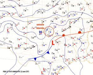
It's not uncommon for this to happen in Texas and Oklahoma during the cold season, but it is rare when it produces tornadoes. One famous situation where this happened was the night of February 21-22, 1975 near Altus, Oklahoma. On that day there was a cold air outbreak in Oklahoma. Gusty north winds, temperatures of 36 degrees, but aloft it was very unstable. Thunderstorms developed and at least six tornadoes touched down around 2 am, one of them F2. Storm Data shows 3 people were killed around the Altus-Mountain View area with 70 injured.

This would have been a pretty scary situation to be in because it's night, it's overcast so you can't see much, and of course there's no good weather data. Since the situation was so unusual I'm not even sure that Gary England was on the TV.
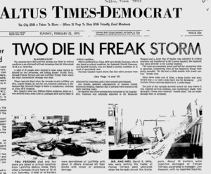
a9827e73c223a7d564df4e7fcc3059de.jpg

Here's a map I generated for that date:
c7036b323aeb43d610d6fbc5e2f0db6e.gif

Observations at Altus AFB from 6 pm earlier that evening until 8 am can be seen here:

KLTS 220000Z 03016G22KT 15SM BKN060 BKN090 07/M02 A2981 RMK SLP097 8/170 T00671016 55002==
KLTS 220100Z 01014KT 15SM BKN060 OVC090 06/M02 A2987 RMK BINOVC W PRESRR SLPNO T00561016==
KLTS 220200Z 03020G26KT 10SM SCT060 BKN080 06/M03 A2984 RMK PRESFR SLPNO T00561027==
KLTS 220300Z 03020G28KT 10SM BKN080 BKN200 06/M03 A2988 RMK SLP119 8/078 T00561027 52022==
KLTS 220400Z 03025G34KT 10SM BKN080 OVC200 05/M03 A2986 RMK THN SPOTS INOVC SLPNO T00501027==
KLTS 220500Z 04026G35KT 10SM SCT080 BKN200 05/M03 A2981 RMK PK WND 0336/0358 111111 SLPNO T00501027==
KLTS 220600Z 03030G38KT 15SM SCT080 BKN200 05/M03 A2974 RMK CB 75SW AND 10S-50SW-83W M 9% NNE OCNL LTGICCCCG PRESFR/ SLP070 60000 8/078 T00501032 58046==
KLTS 220800Z 03025G35KT 3SM CLR 02/M01 A2983 RMK TORNADO E45 MOVD NNE T ALQDS MOVG NNE FQT LTGICC HLSTO PRESRR WET RWY SLPNO T00221011 530/4==
KLTS 220900Z 03025G35KT 3SM BKN035 OVC060 02/M01 A2989 RMK TORNADO E0645 MOVD NNE T ALQDS MOVG NE FQT LTGICCC HLST/ PRESRR/251 137/ WET RWY SLP124 T00221011 530/4==
KLTS 221000Z 33015G20KT 1SM BKN015 OVC035 01/00 A2994 RMK SLPNO T00110000==
KLTS 221100Z 01027G39KT 3/4SM OVC010 01/01 A2985 RMK SLPNO T00060006==
KLTS 221200Z 03035G48KT 7SM CLR 01/01 A2980 RMK T E50 MOVD NE CB 11)-85S MOVG NE OCNL LTGICCC E PRES UNSTDY/73045 90401 LSR13P SLP093 60045 70045 8/9// T00060006 52000==
KLTS 221300Z 03035G49KT 7SM BKN008 BKN030 01/01 A2984 RMK SLR13P 111111 11E-100SE-85S MOVG NE OCNL LTGICCC E PRES UNSTDY/ SLP093 8/9// T00110011 57030==
KLTS 221400Z 01030G39KT 10SM BKN008 BKN030 OVC100 01/01 A2991 RMK PK WND 0345/21 SLR 13P SLPNO T00060006==
 
Thanks for posting that up, Tim - I recalled that this event had occurred but couldn't remember when and so didn't want to try to guess! It is, of course, a shame there is no ascent for this event - I would be very interested in seeing how shallow the cold layer was. Given that some high resolution simulations of supercells depict much, if not all, of the air entering the base of the tornado being from within the storm (i.e. cooler than the ambient inflow air, which appears to enter the updraught at some level above the surface) I guess the layer could be around 500-1000 metres deep, and still have a strong enough updraught to lift the cooler surface air, and stretch the vorticity. Do you know if the storms had formed further south as powerful supercells and then continued north (or north-east)?
 
Storm data says that the severe weather was confined to southwest Oklahoma and to Quanah-Burkburnett in Texas. Some storms redeveloped the next afternoon in the Texarkana-Marshall area.

Unfortunately NCDC doesn't appear to have any functional archive of any radar data from the 1970s. Digital "SD" (RAREPs) do exist, along with hourly screenshots from the WSR-57s and 74s, but the last I checked none of this has been digitized and I don't know if they have any ability to pull the records.
 
If you want an unlikely tornado, here you go:
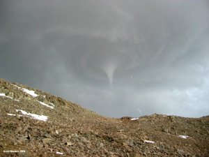
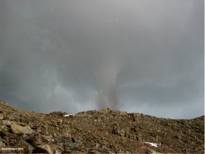
http://tornado.sfsu.edu/RockwellPassTornado/

The highest elevation tornado ever recorded, and it was in California of all places.(there was another tornado in Colorado that fell short of beating this record by by just 100ft as well). The most interesting thing about this particular tornado is there is evidence that it was spawned from a Supercell rather than just being a landspout tornado considering the storm structure and severe hail that was associated with this particular thunderstorm.

300c1df6e9b1bfa0dec5d527ec6f24df.jpg

629f33a20ad3cc76e47aa881e497dd92.jpg
 
The Atlanta basketball tournament tornado of 2008 was not expected. No severe-thunderstorm watch. No tornado watch. According to an Atlanta broadcast met, some stations didn't go on the air with warnings for 20-30 minutes. The mets had gone to dinner, thinking nothing would happen.

http://www.calhouncountyjournal.com/mykal-riley-may-have-saved-lives-as-tornado-strikes-georgia-dome/

Amazing story. An Alabama three-pointer at the buzzer sent the game to overtime. Had the player missed the shot, it is likely thousands of fans would have been outside the arena when the tornado hit.
 
I remember while chasing the Tulsa area the day of the Sand Springs tornado in 2015, being taken aback by reports of a tornado in Moore. Seemed like a pretty garden variety cell on radar. I found out later after researching it that the storm interacted with a kink in an outflow boundary where it could ingest that vorticity along the ofb and spun up that brief ef2.
 
I’m not sure if that would perfectly match the question but most people I met don’t realize that tornadoes could hit the mountains. There were a few instances of tornadoes hitting Great Smoky Mountains National Park and nearby areas, including behemoth 2011 EF4+ (there’s uncertainty if it was actually EF4 or EF5 according to researchers involved in this study due to its remote location but its still official EF4 by NWS). Some people were surprised about tornadoes hitting Smokies. I think it has more to do with people belief than conditions themselves
 
Back
Top