Andrea Griffa
EF5
Scary night on may 23. After we intercepted the 3 Quinter wedges, we decided to catch the last supercell heading toward Hays. The supercell was hooking up and we left the interstate and we took the exit to Ellis. We entered the city with the sound of the tornado siren and 8.20 and Ellis was hit by the first tornado at 8.32. After that the sky became dark and visibility was so low.
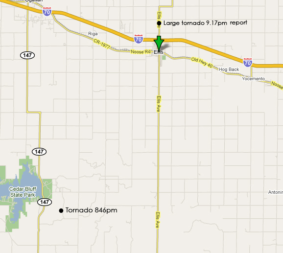
At 8.45 we stopped 5 miles south of Ellis along Ellis Avnue(the street with Nort-South direction that goes to Ellis-you can see on the map). The first tornado was reported at the radio on 8.46 but we couldn't see it because of obscurity and bacause of HP features of the supercell. In the meanwhile the supercell was coming toward NE. I saw two points of high shear on the WX:150 mph of shear at SW of us and 138mph N of us. There were two tornado at the ground: one smaller tornado and a large tornado on the ground. The problem was that we remained in trap with no visibility with the large tornado probably few kilometers west or SW of us and another tornado N of us. We decided to head to Ellis, stay in the middle of the two tornadoes, and take the interstates another time because we couldn't see any tornadoes from that position and the wind was becoming too strong.The RFD,before, was incredibly strong and the dusty inflow was too powerful. I was few miles from Ellis at 9 pm.We arrived at 9.09 pm in Ellis and at 9.11pm we took the interstates. At 9.17 was reported the large tornado I was talking before just 1 mile N of the interstates(from the Ellis exit) but I couldn't see it because we felt the tornado too near and it was better to get away instead of stop and film it.
The reason why I'm writing this thread is to draw a map with the path of the two last tornadoes, so I'm asking someone help to do this. I saw Kourunis and Edwards report, and it could be interesting to know your position at that time in relation with the tornado you got. I started to put down two sure reports: one at 8.46 and the other one at 9.17.
Thanks to all

