• A friendly and periodic reminder of the rules we use for fostering high SNR and quality conversation and interaction at Stormtrack: Forum rules

    P.S. - Nothing specific happened to prompt this message! No one is in trouble, there are no flame wars in effect, nor any inappropriate conversation ongoing. This is being posted sitewide as a casual refresher.

May 19th 2013 Help

Joined
Jul 2, 2014
Messages
50
There seems to be a lack of damage photos from the May 19th 2013 tornado outbreak, particularly the Edmond EF1, Lake Arcadia EF0, Carney EF3 & Shawnee EF4. Does anyone have any damage survey photos from those tornadoes? Im doing a project on this event. All photos will be credited to those individuals.
 
The NWS in Norman has an entire page dedicated to both the May 19, 2013 and May 20, 2013 tornado outbreaks. If there isn't sufficient evidence there, you can always use DAT: ArcGIS Web Application

Go to the top right and enter in the dates (I would go a day early and maybe several days later as survey dates can vary sometimes, depending on offices), then you should see all the tracks for the Shawnee EF4, Carney EF3, Moore EF5, Edmond EF1. Some damage indicators do have photographs attached to them from the survey showing the degree of damage that occurred at that point along with a description of how they arrived at such rating.

NWS Norman: The Tornado Outbreak of May 19, 2013

For what it is worth, the NWS page seems to be having some issues today, so I would perhaps just keep trying it. It has been slow for me all day.

Authors edit: I just now realized looking back at DAT, how close Shawnee, OK came to complete disaster on 5/19/13. Survey data shows estimated wind speeds of 190 mph just NW of town in some of the worst damage areas. If this had been a tad further SE, I think it would have been a far worse outcome, even worse than what occurred. Of course this was overshadowed by the next day's horror in Moore, OK.

Screen Shot 2022-08-25 at 5.12.18 PM.png
 
The NWS in Norman has an entire page dedicated to both the May 19, 2013 and May 20, 2013 tornado outbreaks. If there isn't sufficient evidence there, you can always use DAT: ArcGIS Web Application

Go to the top right and enter in the dates (I would go a day early and maybe several days later as survey dates can vary sometimes, depending on offices), then you should see all the tracks for the Shawnee EF4, Carney EF3, Moore EF5, Edmond EF1. Some damage indicators do have photographs attached to them from the survey showing the degree of damage that occurred at that point along with a description of how they arrived at such rating.

NWS Norman: The Tornado Outbreak of May 19, 2013

For what it is worth, the NWS page seems to be having some issues today, so I would perhaps just keep trying it. It has been slow for me all day.

Authors edit: I just now realized looking back at DAT, how close Shawnee, OK came to complete disaster on 5/19/13. Survey data shows estimated wind speeds of 190 mph just NW of town in some of the worst damage areas. If this had been a tad further SE, I think it would have been a far worse outcome, even worse than what occurred. Of course this was overshadowed by the next day's horror in Moore, OK.

View attachment 23102
Right! The DAT doesn’t really have many damage photos from that event. I’ve seen the NWS Norman’s page. It’s fantastic but doesn’t have damage photos of all the other tornadoes.
 
The NWS in Norman has an entire page dedicated to both the May 19, 2013 and May 20, 2013 tornado outbreaks. If there isn't sufficient evidence there, you can always use DAT: ArcGIS Web Application

Go to the top right and enter in the dates (I would go a day early and maybe several days later as survey dates can vary sometimes, depending on offices), then you should see all the tracks for the Shawnee EF4, Carney EF3, Moore EF5, Edmond EF1. Some damage indicators do have photographs attached to them from the survey showing the degree of damage that occurred at that point along with a description of how they arrived at such rating.

NWS Norman: The Tornado Outbreak of May 19, 2013

For what it is worth, the NWS page seems to be having some issues today, so I would perhaps just keep trying it. It has been slow for me all day.

Authors edit: I just now realized looking back at DAT, how close Shawnee, OK came to complete disaster on 5/19/13. Survey data shows estimated wind speeds of 190 mph just NW of town in some of the worst damage areas. If this had been a tad further SE, I think it would have been a far worse outcome, even worse than what occurred. Of course this was overshadowed by the next day's horror in Moore, OK.

View attachment 23102
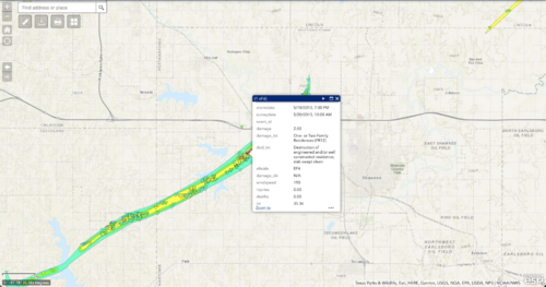
Also agreed, the few damage photos I’ve seen from Bethel Acres was absolutely insane. There was Moore level tree debarking/scouring in some areas. I think had that hit Shawnee head on we would’ve probably seen 2 consecutive days with EF5s.
 
Back
Top