Mangum, OK tornado from Highway 34 on 5/20?

Joined
Aug 9, 2012
Messages
585
Location
Macomb, IL
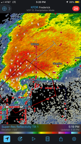
Does anyone know if the Mangum, OK tornado was visible from Highway 34/1550 north of East Duke around 5:10pm on May 20th? I got this shot looking northeast from about 5+ miles away while stuck in the chaser congo and I'm not sure if it was the actual tornado or not. Looks quite convincing to me. It's a video still from my video I got about 30 seconds from, contrast enhanced, while looking through my video from this season tonight. The only shot I got as it was moving away before disappearing into a wall of haze and murkiness. I can't find an actual survey of this tornado that shows the beginning and end times or path length from OUN, so I'm clueless on that. Opinions welcomed from anyone that was there and distant.

19043
 
It was definitely visible from that highway. This is from a few miles up the road from where you took your picture and likely taken around the same time:

74d246acc766b71cda93b066ca00c969.jpg
 
Yeah it was visible from 34. I was on 1520 then driving north up 34 at about 1:45 in this video

Also, do you have a further zoomed out shot? Would be interested to see if you can see the RFD cut from your photo. Seems like you'd have had a pretty good shot at the cut.
 
Here is a wider shot of the storm, sorry about the quality, my settings on my DSLR were way off hence how dark and grainy it is :/. Time on LR5 says 5:06pm on this photograph. Again haze makes it hard to discern, my video was crap because of the haze. I couldn't get any closer because of the chaser traffic and I got stuck about 15 minutes prior which cost us a closer view of the storm.

19048

Seems similar to @Devin Pitts shot, but I'm not sure the timing on his photograph. I'd love to see a survey, but I don't know if Norman has released one or not.
 
Check out my map on Mangum, OK Tornado - Ben Holcomb - As you can see from my video I was probably 1/4 mile away from touchdown on 1520 and then almost in it on the west side of Mangum. Just draw a line between the two points and you should have a decently accurate track map. It turned more right in north Mangum.
 
Back
Top