Low Clouds

Tom Mull

EF0
Joined
Apr 14, 2011
Messages
41
Location
Wildwood, MO
Went storm chasing last week. A cold front was coming through and I thought there might be some storms to view. Unfortunately, there was a low cloud deck and all I could see was the rain coming out of the bottom of some of the storms. When looking to chase storms, how can I tell if there are going to be low clouds blocking the view of what is happening higher up in the storms? Thanks.
 
I will take a crack at this, with the expectation that better answers will follow.

Since I don't know exactly what day you were chasing, it's difficult to know exactly what conditions you encountered. For instance, were you in the warm sector ahead of the cold front? In the cold air behind the front, but the cold front was of type "anafront", where the warm air flows up and over the cold air and causes widespread cloudiness and precipitation a good distance behind the front?

One thing you can do is look at surface data plots (METAR data) -- check stations in your target area that report cloud cover and cloud ceilings. (Not all do.)

For instance, if the target area sky cover reports are predominantly "overcast with low ceilings" you can anticipate poor visibility of storm structure, etc. If the stations are reporting scattered or broken low- and middle-layers, then things get better. (If you are not familiar with METAR reports, there are plenty of sources on the internet available via search engine.)

I am not proficient enough using satellite imagery to know how to tell whether or not a "uniform" cloud cover that is visible from space is low or high enough to permit good storm observing. Others will have to chime in. I do know that I have had good viewing of storm structure under overcast skies if the ceiling is high enough--and whether or not it was high enough was not evident to me in satellite photographs.

An example is found in the 5/11/2023 event report, where individual supercells were visible from the ground even though satellite and radar views did not resolve individual cells. (I'm ignoring overshooting tops which did indicate the positions of the cells but did not resolve them in the way I mean.)

I hope this helps.


Thanks for the input. I was ahead of the front on the warm side on 5/19 as a cold front moved through mid Missouri. I was expecting storms to develop ahead of the front, which they did. The low cloud deck kept me from seeing most of the storms.
 
Thanks for the input. I was ahead of the front on the warm side on 5/19 as a cold front moved through mid Missouri. I was expecting storms to develop ahead of the front, which they did. The low cloud deck kept me from seeing most of the storms.

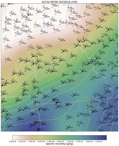
As you found out ceilings in the area were pretty low. From a sampling of local METAR reports, 4PM ceilings varied from ~9000 ft at Rolla and Lebanon (KVIH & KLBO), to 700 ft at Warsaw (KRAW); not sure where you were. You can't see too much detail in the WPC surface analysis (WPC surface analysis zoom, pan, animation and archives), but a more detailed surface plot looks like this:

MFC_METAR_20230519_2100_20230525_1156.jpg

(The filled-contours here are specific humidity, which is just the default for the plot. I know you probably don't care about that! I just ran this off without changing settings....)

It's not clear from the data where skies open up a bit. Certainly along the Farmington-West Plains axis (KFAM-KUNO). I think sometimes you just have to get out there and see for yourself.
 
gdlewen said:
I am not proficient enough using satellite imagery to know how to tell whether or not a "uniform" cloud cover that is visible from space is low or high enough to permit good storm observing.
One thing I can say with satellite (and not sure how helpful it would be since I've never actually tried, but it sure seems like it'd be pretty useful)..
A single satellite image won't do much good, but viewing a satellite loop, you can easily see higher clouds flowing over a lower layer. (this ofcourse assumes directional or speed shear(but if you didn't have that you wouldn't be looking at storms anyway. .lol. ))
(That said, actually even with a single image you can still sometimes make out there being a low-level cloud layer. Watching a loop confirms it)
 
Most folks are interested in viewing the updraft area of a storm. If all you see is rain, then the angle at which you are viewing the updraft is obscured by the downdraft...as an incredibly vague and wide-brushed statement.

It sounds like you encountered a "line" of storms, maybe a QLCS (Quasi-linear convective system). Typically the most photogenic presentation here would be a shelf cloud and a nice lightning show.

If you're chasing a "discrete" storm, which is a storm relatively by itself, then your view is a direct outcome of your position relative to the storm. In the northern hemisphere, most storms are best viewed from the southern aspect..though this is not a hard and fast rule. Storm type, time of day/sun angle, and general storm direction are all important to consider a good viewing position.
 
Back
Top