Derecho of 6 June 2020

GPhillips

EF4
Joined
Jul 8, 2004
Messages
327
Location
Topeka KS
I was watching the storms in CO and WY on radar yesterday afternoon and was somewhat amazed at the ongoing wind damage in that area. I hadn't seen anything like it from convective storms in that area in my memory. The event lasted all the way up into southwest ND with lots of severe gusts, damage reports, and some high end gusts.
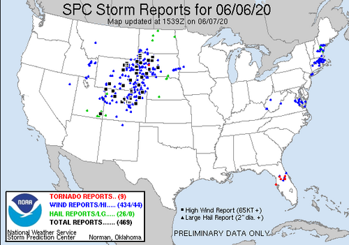
SvrRpts6June2020.png

I questioned whether this event would make it on SPC's "Noteworthy Events" Derecho webpage at the time, and now it looks like it probably will. Liz Leitman from SPC tweeted a comparison to previous significant organized convective wind events in the area and you can see it here:

 
Last edited:
I don't know if it was considered a derecho or just a squall-line at that point, but I got hit by this system yesterday - it passed right over the house.
(infact I was purposely outside (on the roof) with the videocamera when the front line of it hit)

I was thinking about making a thread on it myself/posting some pic's later, depending on how things turn out..
 
On I-90 I saw power poles going down on both sides of the freeway. Two semis went over in front of us and another behind us. A hood was ripped off another semi and I had the tonneau cover on my truck ripped off. I also saw three more vehicles that were blown off the road shortly before getting there.
First and foremost I hope nobody was injured in any of the vehicles. It was the most exciting day of my chase season so far, which isn’t saying much. I may be having a recency bias, but I don’t recall seeing stronger straight line winds than those yesterday.
 
Here’s some more local information regarding the derecho event on Saturday. More odd events are piling up to make 2020 a most unusual year.
 
Back
Top