DavidThomas
EF0
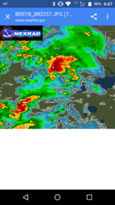
Hey y'all. Here is the only radar image I could find that most likely showed what the storm looked like the moment that this tornado touched down. My current home is about a mile due west of the hook echo in this image. Can anyone tell me what info can be determined from this radar image?
Sent from my XT1585 using Stormtrack mobile app
Sent from my XT1585 using Stormtrack mobile app