5/7/06 REPORTS - TX / OK / KS

Joined
Apr 7, 2006
Messages
45
Location
Bernville, PA
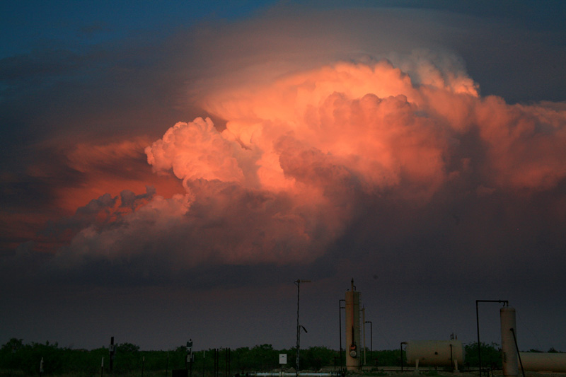
050705-MidlandCoTx6.jpg

We watched one cell struggle and die a horrible death just south of Lamesa then raced for the on-going severe warned cells south of the Midland/Odessa area. We intercepted the northwestern most cell in the fading light. Not exactly what we were hoping for, but the final towers washed in colors by the setting were a nice ending to the day.

Photos here: http://www.stormeffects.com/recent_events.htm
 
Well... This was a travel day, but I suggested to my chaser newbie friend Steve that we might drive back from Woodward toward I-25 by way of Liberal, KS, and up to US160 at Ulysses. The morning progs suggested a nice dryline along the CO-KS border plus pretty good instability, shear and moisture in that area and down into the OK panhandle.

A story of rather poor execution (with limited on-board information).... Cells started going up fast in mid-afternoon as we turned west on US160 on the CO border, particularly down south of Springfield and up near Sharon Springs, KS or something like that. But it was early, I thought, and the impulse from the west wasn't supposedly due for a few hours. So lo-and-behold we zip west under a tiny shower with some small soft hail at the border -- east of Walsh, CO. Dean calls to tell of the severe about 100 miles north, while cells in between seemed to be struggling. Meanwhile the cell south of Springfield is tail-end Charlie but only just about holding its own.

I decided to continue into Springfield, engage in some personal outflow, and decide what to do. Just as we're pulling in, Dean calls with the Elkhart obs -- something like kinda cool/54dp with a full gale from the SSE. He says, "That's gotta be some impulse coming!" I thinks, holy crap! That's what we zoomed through 25 miles back.

Getting back east and trying to get in front of and past the struggling tail-end storm to the south was the (wrong) decison. Unfortunately as we pulled into Elkhart the former struggling storm was getting frisky almost overhead, and I wimped out on blasting south, instead retreating up toward Rolla for another end-around attempt. She was moving just a bit too fast for the time left and I gave up in Hooker about the time just west of Guymon was getting pummeled by golf balls. Dean called to report the Garden City area tor warnings. As I was filling the tank in Hooker a little shear funnel snaked down a bit from the flanking updraft shelf just to my southwest as if to say, "Sukka! Should'a gone north!" :p
 
A cold front sparked some linear junk in North Dakota. Drove about 40 minutes northwest of Grand Forks to find visually unappealing storms but more CGs than expected. I get back home and shelf cloud begins to take shape. Snapped a couple pics and went to bed. The line was intensifying a bit at this time but daylight was fading. There was a tor warn a few hours later about 50 miles to my east.
horiz.JPG
 
My son Michael and I rolled the dice on a weak setup but scored big last night in western KS. We caught 3 confirmed tornadoes and 1 funnel that dissipated just before moving into Garden City, KS. It was a very interesting chase as storm motions were almost straight south and nice and slow - hello May!!! Got in late last night and am very tired but here are some pics and video. :)

>> Click here for full report <<
>> Click here for video <<

20060507_Meso_1_sm.jpg

Meso northwest of Garden City, KS

20060507_T3_1_sm.jpg

Called this tornado in 10 miles northwest of Garden City, KS

20060507_T3_4.jpg

Tornado grows to a nice trunk shape

20060507_T4_3_sm.jpg

Funnel aloft just outside Garden City, KS

>> Click here for full report <<
>> Click here for video <<
 
My son Michael and I rolled the dice on a weak setup but scored big last night in western KS. We caught 3 confirmed tornadoes and 1 funnel that dissipated just before moving into Garden City, KS. It was a very interesting chase as storm motions were almost straight south and nice and slow - hello May!!! Got in late last night and am very tired but here are some pics and video. :)
[/b]

Hi Verne, sure nice to see some slow movers, isn't it?

Nice video and pics, congrats to you both!!

John
VE4 JTH
 
Spent the day in extreme S TX, playing the 'old faithful' cell near Fort Stockton. It rapidly intensified south of Iraan near Sheffield, and was tornado-warned. Tried to head south through th hills, but ran into big hail, and since we had just smashed the windshield fri near Seminole, didnt want a repeat. The storm was incredible at sunset, with pileus, lightning and rising moon all combining to put on quit a show. Had much "fun" driving all the way back to KS today for the blow-out east of Scott/Gardn City. Hopefully better luck this day.
 
Back
Top