J Miller
Enthusiast
- Joined
- Mar 14, 2025
- Messages
- 2

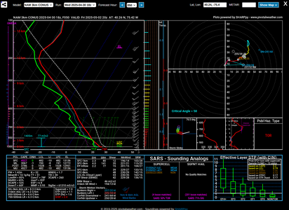
Interesting point sounding from NAM3K, there's large areas with cape above 1000 J/kg. What got me really happy was mid level lapse rates above 6 degrees per km, which is surprising given the fact that moisture is fairly high between 700-500 mb. Hodo is kinda ass, but with the spaghetti bowl hodos I'm used to, something that's comprehendable with the naked eye is a welcome change. Sfc -6km bulk shear being nearly 40 kts and SRH being actually notable makes me hopeful that during the late afternoon before storms go upscale we might actually get something. While I'm not confident in a tornado, we might actually get somewhat strong updrafts that last long enough to take some pretty pictures. I was talking with some other people, and they said to absolutely watch out for hail, but I really don't know anything about forecasting hail. This is just one run of 3k at 20z, does anyone else see anything interesting that I didn't see or might want to think about?
Edit: well, SBCAPE downtrended, the hodo looks way worse, upper level winds might as well be non existent. Looks like another sloppy day.
Last edited:
