Dan Robinson
EF5
The no-brainer tornado target this day was supercells along a warm front in central Missouri that most models showed getting started around noon. The same front stretched east through the St. Louis area, and was a threat for tornadoes there if any storms were to develop that far east. I was willing to ditch the sure-thing target farther west for that backyard chance, but as the morning progressed all model and realtime data (including visible satellite) pointed to those storms being very unlikely.
I departed just after the morning church service in O'Fallon and headed west, stopping only to get gas right after church. I then drove straight to the intercept of the storm in Jefferson City that had already developed and produced a tornado earlier. The plan was to intercept just across the river from town and follow the storm north on Highway 54. I reached the storm's updraft as planned, but made a mistake in not realizing that Highway 63 northbound didn't have a turnaround for 3 miles. This allowed the storm to get ahead of me.
The terrain is hilly and forested here, with very few views. For this reason I missed seeing the second short-lived tornado the storm produced near New Bloomfield as I caught up on Highway 54. A few minutes later, the storm developed a massive RFD surge and produced its third and largest tornado southwest of Fulton as it tracked a few miles west of the highway. I could see it from the highway, and my dashcams captured possibly my most pitiful images of a tornado:

Rather than pulling over on the highway and getting distant video through the trees, I decided I wanted to try getting closer at the next west road option and launch the drone once I was within a mile or so of it. But when I reached that road, the tornado had already dissipated quickly as the previous two had done.
The next RFD surge was already racing overhead, and it appeared the next tornado might be happening soon along the highway somewhere near Fulton. However, the storm could never get another good surface inflow channel established before it finally crossed over to the cool side of the warm front and began weakening near I-70. Meanwhile a new updraft went up just to the east of the original storm, appearing to be the next tornado threat. Alas though, this storm too was already north of the front and gradually weakened to nothing near Mexico.
I hung around waiting to see if new updrafts to the south near Columbia could get established, but these also struggled and never appeared to be headed for supercell status. After letting those go, there was nothing else within intercept range other than the main squall line to the west that had a few QLCS circulations. Those are rarely chaseworthy: usually short-lived, wrapped in rain, hard to see and visually unimpressive even if you do manage to get a glimpse. So, I decided to just go back to St. Louis and see if the line would perhaps separate into discrete cells as the low-level jet ramped up into the evening.
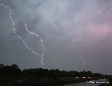
The line failed to separate as it approached the city, but there was lead stratiform precip far ahead of it - and it was producing lightning. I set up at the Shrewsbury towers for this. Only one upward flash was produced, I captured it on all 3 cameras:

Mesoanalysis suggested the storms were outrunning the surface-based instability axis, and a dramatic decrease in the lighntning flash rates seemed to be validating this. On radar, the portion of the main squall line heading into the city was clearly weakening and diaorganized. To the south, though, a portion of the line was intensifying with several strong-looking couplets, each tornado-warned. These were heading toward home, so I packed up at the towers and made my way east.
I parked near I-64 at O'Fallon to watch the line approach. A very strong-looking couplet developed near Waterloo and was heading directly at O'Fallon. This area faded fast (as QLCS circulations often do), but a new one took shape near Mascoutah - tracking very close to the path of the March 14 tornado. Power flashes started bursting on the other side of MidAmerica Airport, very close to where they did on March 14! As I cautiously made my way east on the interstate, I could make out an ill-defined cloud feature racing overhead as winds shifted from easterly to southerly, but nothing definitive.
There was some shredded tree/leaf debris on the interstate near Summerfield Road - again, right where the March 14 tornado tracked. But, I did not find any damage indicative of a tornado. I made passes on Perrin Road, Highway 4, Highway 161 and the interstate looking for tornado damage, but found none. The power was also still on everywhere. After that short damage survey, I was done for the day and arrived home before 10pm.
I departed just after the morning church service in O'Fallon and headed west, stopping only to get gas right after church. I then drove straight to the intercept of the storm in Jefferson City that had already developed and produced a tornado earlier. The plan was to intercept just across the river from town and follow the storm north on Highway 54. I reached the storm's updraft as planned, but made a mistake in not realizing that Highway 63 northbound didn't have a turnaround for 3 miles. This allowed the storm to get ahead of me.
The terrain is hilly and forested here, with very few views. For this reason I missed seeing the second short-lived tornado the storm produced near New Bloomfield as I caught up on Highway 54. A few minutes later, the storm developed a massive RFD surge and produced its third and largest tornado southwest of Fulton as it tracked a few miles west of the highway. I could see it from the highway, and my dashcams captured possibly my most pitiful images of a tornado:
Rather than pulling over on the highway and getting distant video through the trees, I decided I wanted to try getting closer at the next west road option and launch the drone once I was within a mile or so of it. But when I reached that road, the tornado had already dissipated quickly as the previous two had done.
The next RFD surge was already racing overhead, and it appeared the next tornado might be happening soon along the highway somewhere near Fulton. However, the storm could never get another good surface inflow channel established before it finally crossed over to the cool side of the warm front and began weakening near I-70. Meanwhile a new updraft went up just to the east of the original storm, appearing to be the next tornado threat. Alas though, this storm too was already north of the front and gradually weakened to nothing near Mexico.
I hung around waiting to see if new updrafts to the south near Columbia could get established, but these also struggled and never appeared to be headed for supercell status. After letting those go, there was nothing else within intercept range other than the main squall line to the west that had a few QLCS circulations. Those are rarely chaseworthy: usually short-lived, wrapped in rain, hard to see and visually unimpressive even if you do manage to get a glimpse. So, I decided to just go back to St. Louis and see if the line would perhaps separate into discrete cells as the low-level jet ramped up into the evening.
The line failed to separate as it approached the city, but there was lead stratiform precip far ahead of it - and it was producing lightning. I set up at the Shrewsbury towers for this. Only one upward flash was produced, I captured it on all 3 cameras:
Mesoanalysis suggested the storms were outrunning the surface-based instability axis, and a dramatic decrease in the lighntning flash rates seemed to be validating this. On radar, the portion of the main squall line heading into the city was clearly weakening and diaorganized. To the south, though, a portion of the line was intensifying with several strong-looking couplets, each tornado-warned. These were heading toward home, so I packed up at the towers and made my way east.
I parked near I-64 at O'Fallon to watch the line approach. A very strong-looking couplet developed near Waterloo and was heading directly at O'Fallon. This area faded fast (as QLCS circulations often do), but a new one took shape near Mascoutah - tracking very close to the path of the March 14 tornado. Power flashes started bursting on the other side of MidAmerica Airport, very close to where they did on March 14! As I cautiously made my way east on the interstate, I could make out an ill-defined cloud feature racing overhead as winds shifted from easterly to southerly, but nothing definitive.
There was some shredded tree/leaf debris on the interstate near Summerfield Road - again, right where the March 14 tornado tracked. But, I did not find any damage indicative of a tornado. I made passes on Perrin Road, Highway 4, Highway 161 and the interstate looking for tornado damage, but found none. The power was also still on everywhere. After that short damage survey, I was done for the day and arrived home before 10pm.