Preston Bradley
EF0
This was my first solo chase as a storm chaser and first chase being in the MS Delta. Before this event, my storm chasing experience is limited as most of the chases I have gone on has either been with someone else or has been out in Tornado Alley. I have chased within TN/AR/MS only couple of times, but was with someone. Also, Dixie Alley is not as forgiven as Tornado Alley which forces me to be really picky when and where I chase within Dixie Alley. Given the circumstance with the tornado threat and what the model guidance was indicating the morning of Jan 5th, this day provided me a good opportunity to chase within the MS Delta where it is flat to gain more experience as chaser without putting myself in an unnecessary danger (i.e., chasing at night, QLCS tornadoes, etc.).
Morning data showed a small window of opportunity for discrete cells to develop across the Louisiana and Mississippi Delta ahead of the QLCS that was expected to come across the region shortly afterwards. With the best chance of seeing discrete storms within the Mississippi Delta, I decided to head towards Rolling Fork, MS where I will be able to stop and reassess the model guidance and reposition if necessary. My initial plan was to head towards Mayersville, MS to watch the storms as they passed over the river. Unfortunately, the storms had tracked more northerly than anticipated. I had to back towards to the east and north towards Hollandale, MS.
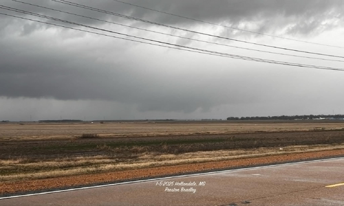
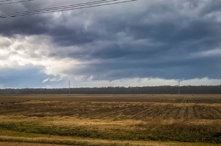
Hollandale, MS was my best bet as the area had not only a decent road options (if needed), but was also south from the two storm cells. This ended up working out for me as I managed to get two really good photos despite having to fight off the on and off rain showers at the time. One of them being a well defined a wall cloud looking northward while the second is a photo of a possible funnel cloud looking back towards the west. While neither of them produced a tornado to my knowledge, it was still considered a win since it was my first solo chase of my storm chasing career.
Photo 1: Wall cloud looking northward on US HWY 61 near Hollandale, MS

Photo 2: Possible funnel cloud above the tree line looking towards the west on US HWY 61 just south of Hollandale, MS.

Morning data showed a small window of opportunity for discrete cells to develop across the Louisiana and Mississippi Delta ahead of the QLCS that was expected to come across the region shortly afterwards. With the best chance of seeing discrete storms within the Mississippi Delta, I decided to head towards Rolling Fork, MS where I will be able to stop and reassess the model guidance and reposition if necessary. My initial plan was to head towards Mayersville, MS to watch the storms as they passed over the river. Unfortunately, the storms had tracked more northerly than anticipated. I had to back towards to the east and north towards Hollandale, MS.
Hollandale, MS was my best bet as the area had not only a decent road options (if needed), but was also south from the two storm cells. This ended up working out for me as I managed to get two really good photos despite having to fight off the on and off rain showers at the time. One of them being a well defined a wall cloud looking northward while the second is a photo of a possible funnel cloud looking back towards the west. While neither of them produced a tornado to my knowledge, it was still considered a win since it was my first solo chase of my storm chasing career.
Photo 1: Wall cloud looking northward on US HWY 61 near Hollandale, MS

Photo 2: Possible funnel cloud above the tree line looking towards the west on US HWY 61 just south of Hollandale, MS.

