Skip Talbot
EF5
On August 6, 2023 an EF2 tracked through eastern Sangamon and Christian Counties, IL with a path more than 25 miles long and up to a quarter mile wide. I've found this one to be interesting for several reasons.
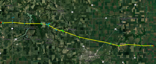
The first was the warning situation. According to the logs, the first tornado warning was issued at 6:24 pm, 15 minutes after the tornado formed at 6:09 pm, and for a storm capable of producing a tornado with a source of radar indicated rotation. The tornado had been reported via Spotter Network in Sangamon County near the start of the track, and several other chasers had reported the tornado later. The warning was upgraded to a TORR at 6:30 pm.
The tornado almost exactly followed the track of an EF1 that was embedded within a derecho on June 29:
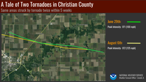
While some chasers described the tornado as a "violent wedge", only a single instance of EF2 level damage was surveyed. The track was mostly over open terrain. Still there seemed to be potential damage indicators along the 25 mile path. I rented a Cessna and overflew the entirety of the surveyed damage path looking for evidence of the tornado from the air.
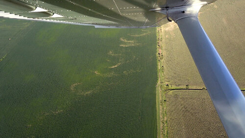
Swirl marks west of Highway 29:
Flattened corn immediately west of Highway 29, note how it abruptly stops at the highway:
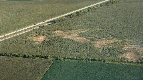
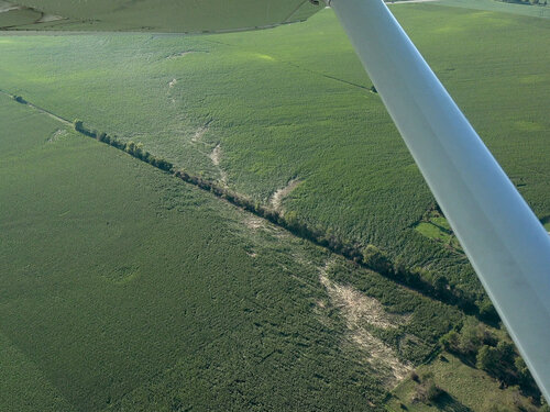
Flattened corn east of Highway 48, yet a very narrow path:
EF2 structure damage east of Highway 48, while the neighbor's house looks largely unaffected:
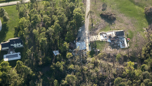
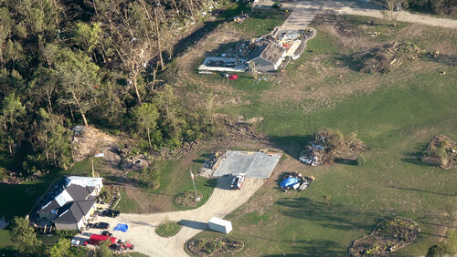
I was surprised at how little evident impact there was from the air. For miles of the path, there seemed to be no marks left at all, the corn largely unaffected. I only found a handful of swirls of intensely flattened corn.
I speculate that the parent tornado/tornado-cyclone level circulation was actually quite weak (EF0). The nearly saturated airmass allowed the funnel to easily fill out at times, while the relatively low bases enhanced the appearance of the tornado's size and motion. It seemed that much smaller and intermittent subvortices were doing the actual damage. I've seen this before with summer time Illinois tornadoes. An unwarned tornado I documented in Sangamon County on July 15 did little more than topple some branches. Andrew Pritchard noted a much larger, wedge like tornado to the east on the same day near Divernon, IL. A group from the University of Illinois went out the next day and found almost no trace of it, the corn unaffected.

The first was the warning situation. According to the logs, the first tornado warning was issued at 6:24 pm, 15 minutes after the tornado formed at 6:09 pm, and for a storm capable of producing a tornado with a source of radar indicated rotation. The tornado had been reported via Spotter Network in Sangamon County near the start of the track, and several other chasers had reported the tornado later. The warning was upgraded to a TORR at 6:30 pm.
The tornado almost exactly followed the track of an EF1 that was embedded within a derecho on June 29:

While some chasers described the tornado as a "violent wedge", only a single instance of EF2 level damage was surveyed. The track was mostly over open terrain. Still there seemed to be potential damage indicators along the 25 mile path. I rented a Cessna and overflew the entirety of the surveyed damage path looking for evidence of the tornado from the air.
Swirl marks west of Highway 29:

Flattened corn immediately west of Highway 29, note how it abruptly stops at the highway:

Flattened corn east of Highway 48, yet a very narrow path:

EF2 structure damage east of Highway 48, while the neighbor's house looks largely unaffected:


I was surprised at how little evident impact there was from the air. For miles of the path, there seemed to be no marks left at all, the corn largely unaffected. I only found a handful of swirls of intensely flattened corn.
I speculate that the parent tornado/tornado-cyclone level circulation was actually quite weak (EF0). The nearly saturated airmass allowed the funnel to easily fill out at times, while the relatively low bases enhanced the appearance of the tornado's size and motion. It seemed that much smaller and intermittent subvortices were doing the actual damage. I've seen this before with summer time Illinois tornadoes. An unwarned tornado I documented in Sangamon County on July 15 did little more than topple some branches. Andrew Pritchard noted a much larger, wedge like tornado to the east on the same day near Divernon, IL. A group from the University of Illinois went out the next day and found almost no trace of it, the corn unaffected.
