2021-05-16 REPORTS: CO/TX

John Farley

Supporter
Joined
Apr 1, 2004
Messages
1,839
Location
Pagosa Springs, CO
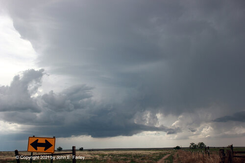
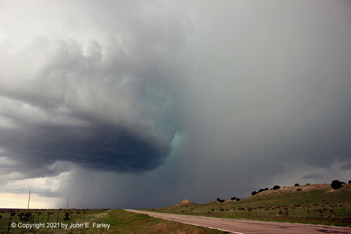
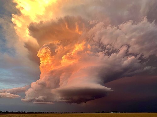
A good forecast put me in the right place today, starting out northwest of La Junta, CO. I picked the wrong storm to see the photogenic tornado that occurred one storm up the line, but is hard to call a storm "wrong" when you get structure like this. The storm started out LP in appearance west of Ordway, then gradually transitioned through classic to HP as it moved toward the SSW. This movement was entirely due to backbuilding/cycling, as mid-level steering winds were almost non-existent. I don't think I have ever seen a supercell literally moving toward its inflow side, but that is what this one did, for about 2 hours. Here are a few pictures; as time permits I will write up a full report.

IMG_0277-e-fb.jpg

IMG_0280-e-fb.jpg

IMG_0309-e-fb.jpg
 
May 16 was a long and arduous day. It began with my ride not showing up at the 5AM designated pickup time. I called the car service and fussed and their office manager came out and got me to the airport in time. The driver overslept. They have been understaffed since many of their drivers had not returned to work. The airport was chaotic with long lines. American instituted a "touchless bag checked in." Even though I had printed out a boarding pass and pre-payed for a checked bag, I had to stand in another line to print my own bag labels. I made it to the flight that was uneventful. At least the completely full airplane was unusually clean. I manged to get a decent rental car in Dallas. Anyone without reservations was out of luck. I was careful not to have worn a storm chase related t-shirt. I stopped off at a Walmart to pick up supplies (paper towels, water, windshield wash etc) and set up the chase vehicle. It was weird in the store as only about 2% of people were wearing masks. I then set up my chase vehicle. This is a time-consuming process to mount cameras and antenna along with arranging other equipment. This would be a chase day with a marginal chance of tornadoes. Time was limited to forecast. I could either go toward Lubbock or farther to the north near Amarillo, Texas. The day was marginal at best due to weak upper level winds. Stronger winds would arrive later, maybe too late. I decided on Amarillo and or maybe Childress which is on the way. It was nice to get back on the road. No gas shortages in Texas! I passed fields of wildflowers under growing puffy cumulus clouds. Storms were forming near Amarillo and also near Childress. Nothing was very impressive. I decided to watch the storms near Childress. The Amarillo storm initially showed more rotation but was outflow dominant. Basically a big dusty blob. Chasers want inflow into the storm and my storm did have that. More storms were forming south of Amarillo. I watched and waited. Several other storm chasers drove by. My storm would occasionally start to show weak rotation, then noting. The storm by Amarillo was bigger but still not impressive on radar or by reports on social media. I decided to give up on my storm and go to Amarillo mainly because that's where I planned to stay for the evening. I'd take some pictures along the way. My direct route to Amarillo was blocked by storms. They weren't worth chasing, and I certainly didn't want to drive through the core and potentially crack my windshield with hail. The following day was forecast to have a much higher potential for tornadoes. I dropped south and headed west as road options were limited. Far to my west, an isolated storm developed that was rotating nicely. It was a low precipitation supercell. These don't make much rain, rarely produce tornadoes, but can be pretty. I wasn't too concerned. Suddenly, I hear reports of a rotating wall cloud and then a tornado. WTF? It did have nice appearance on radar. I stopped and saw numerous reports on social media of a tornado AND beautiful storm structure. Although some storm chasers only want tornadoes, most like myself are happy with beautiful storm structure or a tornado. This storm had both. As I headed west, the storm came into view over 50 miles away. The tornado had ended. Unfortunately, I was on the wrong side to see the beautiful sunlit striated storm structure. I wouldn't make it in time before darkness. I continued west with the storm in the distance to remind me that I missed it. I turned north on II-27 and drove to Amarillo for the evening while enjoying a nice lightning show. Dinner consisted of a piece of frozen lasagna purchased from the front desk of the hotel. Thanks to social media, I get to see what I missed. A classic but rare storm chaser favorite: A beautiful sculpted and striated slow moving storm that also produced a tornado over open countryside. Congratulations to those few storm chasers who managed an intercept. A couple of my friends who are out managed to see the structure from the sunlit side but not the tornado. forshare05162021supercell20210516_204300.jpg
 

This was emblematic of the only category of successful outing I've managed the last five years: fluky, unpredictable, and a day I easily could've (should've?) been at home, barring desperation conspiring with other favorable circumstances. I started in Guymon, where I'd driven the day before for what materialized as an embarrassing squall line that wouldn't even throw me a CG photo op. I was hardly any more excited about the setup on 5/16, but was only a couple hours from the target, so WTH? The sunk costs fallacy is my new best friend these days. I meandered down to AMA lackadaisically after lunch, and was so bored by about 3:30p that I tracked down a good hotel and checked in early! Next, I wandered down to Plainview, where I sat at a gas station for over an hour trying not to fall asleep. I barely even expected to see rotating convection an hour before the show peaked.

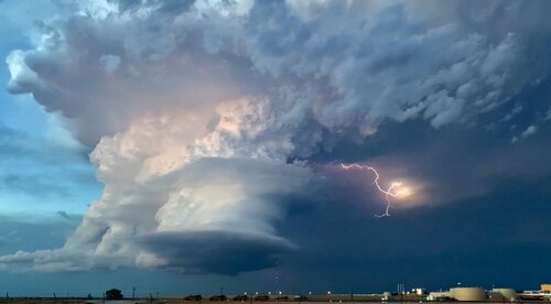
As outflow-dominant supercells developed W of AMA, I suppose I can give myself some credit for sitting tight and not even being tempted by anything other than late development in the better moisture S. By 6:30p or so, scattered new cells were on the uptick to my W and SW, and one around Morton eventually became dominant. Reminiscent of the 5/9/16 Katie-Wynnewood storm, this was a cell whose base immediately re-calibrated my expectations and seriousness upon gaining visual as I approached on US-385. As I crept S and started to catch glimpses of the updraft itself, that seriousness only solidified. By the time I realized I needed to take it seriously for more than just structure, the show was starting: I raced around Amherst and emerged N of town to a view about ~6-8 S of the low-level meso, and the rest is history.

2021-05-17_0186.jpg


2021-05-17_0191.jpg


2021-05-17_0199.jpg


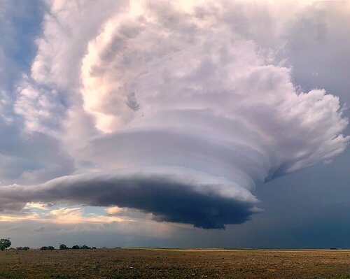
After casually dropping my best structure+tor op since Last Chance in a mesoscale environment I'd probably peg around the 30th percentile from all my chase days, the LP structure bonanza was on... and on and on it went. The first still above was around 7:40p, and I eventually dropped the storm as it dumped golfballs on me at I-27 at 10p. Having earlier locked in a room in AMA turned out to be the most boneheaded move possible when considering the events of 5/17 (especially since I had to work there until 4p); yet, there's something tangibly amusing and worthwhile about notching a career top 10 storm hours after checking into a room early out of boredom and tedium.

2021-05-17_0282.jpg


2021-05-17_0295.jpg


2021-05-17_0314.jpg


How about a crescent moon just high enough to illuminate the textbook LP without blowing it out, for good measure?

2021-05-17_0332.jpg


Irresistible bonus content: this local passed me headed eastbound N of Amherst and claimed to have been casually following the storm for almost 10 miles. WeatherReady Nation has clearly fulfilled its mission entirely and can be disbanded.

2021-05-17_0245.jpg
 

I'm bored on a Tuesday in the early offseason. As it happens, that usually leads me down some brand of memory lane and that usually leads me to some combination of AmWX, Stormtrack, or a really annoying Twitter binge. So here I am.

I woke up on May 16 at my home in Colorado Springs. I rolled out of my bed, jumped in the shower, cooked myself and my chase partner some bacon and eggs, and leisurely threw my cameras in the car and hit I-25. Tomorrow was going to be a big day, but today was just a drive to Amarillo, probably an evening getting wasted on food at the Big Texan, and buzzing down to Lubbock to be asleep by midnight or so. Capulin looked good in the rearview mirror as Raton Mesa spit out 40,000 foot tall supercells across the entire horizon. Dalhart was as pitifully tempting to speed through as always, but the cops there are assholes so I went 25. Yall know how it goes.

The storms west of Amarillo were high based with barely any precip at all, and worst of all there were like three other storms to the east of the storm I was aiming for off the dryline. I have to remind myself a lot that weird evolutions when storm chasing are usually bad, but in this case it didn't take much thought. I had Nick steer us south at about 2:30 PM, through what I expected would be a supercell's hail core but instead turned out to be a piddly rainshower, toward Littlefield. There was a differential heating zone under better kinematics over the caprock that had been in the back of my mind all morning. I didn't expect it to initiate since CAMs were hesitant at best but I was down to try. After a couple hour drive and a brief stop at McDonald's there were three budding supercells competing with one another. Game on.

One supercell became dominant. My chase partner urged me to get him directions to get closer while I wanted to sit back, but I relented and it took us down a dirt road south out of Earth. We punched through the hail and stopped literally 100 feet from the southern edge of the hail core directly in the path of the incoming mesocyclone.
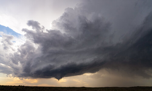
5-16-2021-Earth-TX-XV.jpg

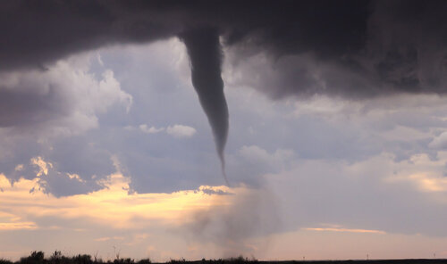
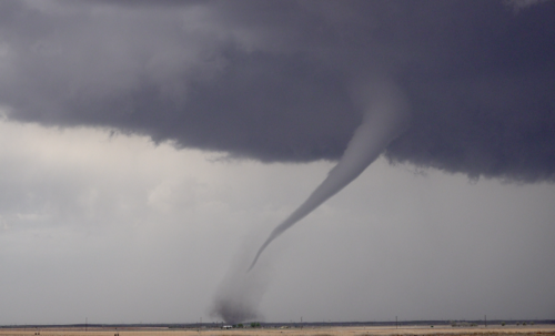
Everyone on this forum knows what tornadic motion looks like and this storm had it. It was impossible to miss. For at least 30 minutes it spun endlessly, and at one point weakly funneled but cycled out. I'm notoriously impatient and this storm, sculpted, thrilling, and remarkable as it was was eating away the little patience I brought with me. A few rogue hailstones in the forehead kept me grounded and shortly later the first tornado developed. I shot the first two photos here at 14mm.
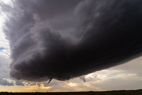
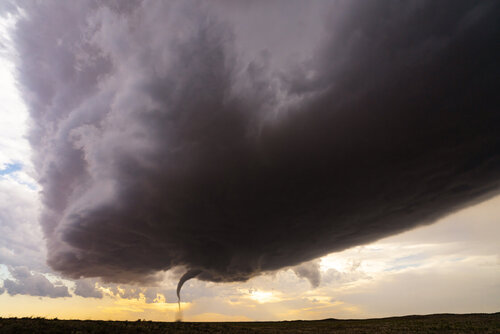
5-16-2021-Earth-TX-XVII.jpg

5-16-2021-Earth-TX-II.jpg

5-16-2021-Earth-TX-XIII.jpg

The evolution of the tornado was excellent. It was classic in every way. The ropeout, though, was special. There were numerous swirls and kinks in the funnel. There were three helical vortices followed by dramatic breakdowns. All the while it appeared to be cycling into another tornado that forced us to move to the east the moment it was finished.
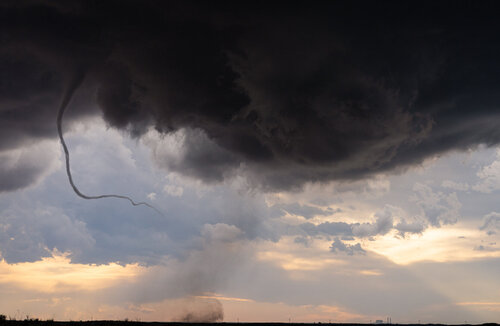
5-16-2021-Earth-TX-XXII.jpg

The cyclone passed just to our north, producing only one more dust swirl a few hundred yards from us on the way. But the storm didn't seem like it was done. Noting that there hadn't been even the slightest bit of rain in the first tornado's RFD, I wanted to stay to the west of the next tornado. Had it produced in a similar way from this angle, I think the first tornado would be forgettable. It would go on to form three more brief, uncondensed tornadoes, but none compared to the first.
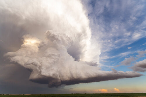
5-16-2021-Earth-TX-VII.jpg

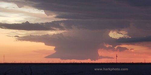
As the sun set, tornado chances fizzled, but the storm kept going. An updraft column would weaken and another would take over. A surface inversion would form and then the storm would punch through it and restrengthen. It was miraculous, so much so that I basically forgot to position us in a way that we could easily document it and just watched. But that doesn't really matter.
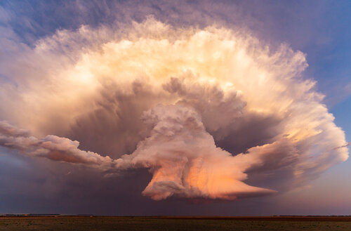
5-16-2021-Earth-TX-XXVI.jpg

In the event I ever see a storm of this caliber that is this cooperative again, I'll try and post it here before late September. No promises though.
 
Back
Top