• After witnessing the continued decrease of involvement in the SpotterNetwork staff in serving SN members with troubleshooting issues recently, I have unilaterally decided to terminate the relationship between SpotterNetwork's support and Stormtrack. I have witnessed multiple users unable to receive support weeks after initiating help threads on the forum. I find this lack of response from SpotterNetwork officials disappointing and a failure to hold up their end of the agreement that was made years ago, before I took over management of this site. In my opinion, having Stormtrack users sit and wait for so long to receive help on SpotterNetwork issues on the Stormtrack forums reflects poorly not only on SpotterNetwork, but on Stormtrack and (by association) me as well. Since the issue has not been satisfactorily addressed, I no longer wish for the Stormtrack forum to be associated with SpotterNetwork.

    I apologize to those who continue to have issues with the service and continue to see their issues left unaddressed. Please understand that the connection between ST and SN was put in place long before I had any say over it. But now that I am the "captain of this ship," it is within my right (nay, duty) to make adjustments as I see necessary. Ending this relationship is such an adjustment.

    For those who continue to need help, I recommend navigating a web browswer to SpotterNetwork's About page, and seeking the individuals listed on that page for all further inquiries about SpotterNetwork.

    From this moment forward, the SpotterNetwork sub-forum has been hidden/deleted and there will be no assurance that any SpotterNetwork issues brought up in any of Stormtrack's other sub-forums will be addressed. Do not rely on Stormtrack for help with SpotterNetwork issues.

    Sincerely, Jeff D.

2021-03-27 EVENT: AR/TN/MS/LA/TX

Joined
Mar 30, 2008
Messages
1,476
Location
Norman, OK
A small little event tomorrow in Arkansas. A neutral tilt, compact jet slamming into the high over south florida. A decent low level response will bring up an extremely moisture-rich air mass from the gulf. 00Z LCH and LIX are showing a pretty moist column under 3km.

NAM and HRRR guidance show a warm front advancing north to around I-30/I-40 through Arkansas and TN. Both models are showing dewpoints near 70F especially pooling along the warm front. While I've seen some subsidence in the soundings, both models are blowing up storms along the 30/40 cooridor.

It seems like low level shear/helicity is somewhat sub optimal for tornadoes, but hopefully it will be enhanced along the warm front. Definitely think there will be something tomorrow. Hoping for some storms along the Delta.
 
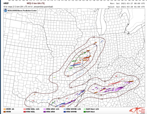
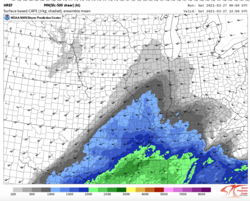
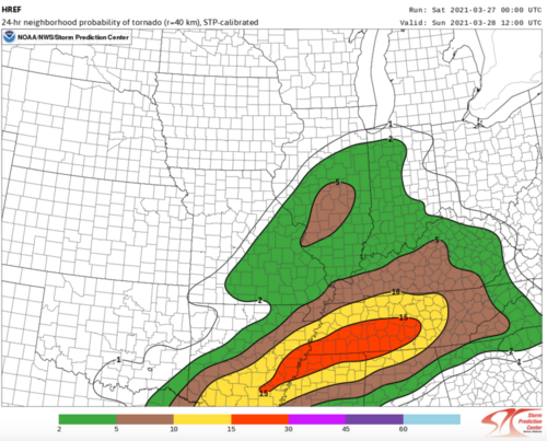
Mods add IL/MO to this thread as well. Expecting severe thunderstorms to initiate along a cold front around 22-00z this evening near St Louis area northeastward. While the degree of moisture up here remains in question, I do expect at least 1500 j/kg of CAPE combined with 60-70 knots of bulk shear to be sufficient for severe thunderstorms including a few supercells as well as a jet streak enters the region this evening from the SW. The 00z HREF has picked up on this and is showing a favorable corridor of UH tracks from St Louis northeast toward Springfield, IL after 00z. With lapse rates being steep as well, I expect a handful of large hail reports, along with possibly several damaging wind reports and after 00z the low end risk of a couple tornadoes depending on storm mode. My target right now is 7pm around Greenville, IL. Not expecting a tornado chase out of this one, but also not ruling it out either. Only 3rd chase of the season for me, hoping to go 3/3! Here are a few graphics I referenced looking at this morning's data to make my forecast:

Screen Shot 2021-03-27 at 8.56.53 AM.png

Screen Shot 2021-03-27 at 8.59.17 AM.png

Screen Shot 2021-03-27 at 8.59.34 AM.png
 
Corinth, Mississippi to Muscle Shoals, Alabama is our Target, with options to hold in Huntsville or push to Memphis. About to depart Chattanooga so this is quick.

Dixie climo favors that Corinth to Shoals if a north-south convergence zone can develop. Outflow is the obvious east-west boundary. No rainy WF. We will follow that OFB / trough intersection. If necessary adjust west or east on US-72/Alt-72.

Cells split near Chattanooga this morning, which is no surprise. Low level hodos are excellent; then, it gets long upstairs. Splits are fine. Right mover makes an easy chase decision.

Updates from the field will be on the Storm Track Discord Server 3-27 thread/channel. Everyone be safe and good luck!
 
Back
Top