Quincy Vagell
EF4
What a day. I forced myself to go to sleep early last night, but in anticipation of today, I was up by 2 a.m. I ended up leaving Oklahoma City by 4:30 and that gave me enough time to get to northeastern Colorado with about an hour to spare. With prospects of 3000+ CAPE with 40+ knots of shear in Colorado, I was cautiously optimistic about what the day would have in store.
I watched the first few echoes go up in Yuma County early in the afternoon and decided it was best to stay put, even though I toyed with the idea of possibly targeting the cluster coming out of Nebraska. Needless to say, I did not do that.
A pair of cells evolved into supercell structures with prominent wall clouds, to the southwest of Wray. At first, the northern cell looked dominant, but it suddenly started withering away, giving way to a more classic-looking supercell to the south. I managed to get back to US-385 just in time to dart south and then west on US-36 for a closer look. I watched a tornado from start to finish, even though I was not particularly close. The rough estimate was that the tornado lasted about 7-8 minutes or so and toward the end, there was about a minute with two tornadoes side-by-side. (Low resolution screenshot below)

The initial (main) tornado began to rope out shortly after its twin lifted. I did not manage to stop for any photos, as I was getting rained on pretty hard, power lines were in the way and I was hoping to intercept the storm as it moved south. I have some video (not the best quality), but it does cover the vast majority of the life cycles of the tornadoes.
I chased the storms for a while, but after the initial tornadoes, the setup was generally messy. I closed in on a rain-wrapped, occluding mesocyclone north of Bethune, but with questionable road conditions and very large hail, I got back south to avoid getting stuck or a busted windshield.
It wasn't much later that the storms were throwing out quite a bit of outflow and the tornado potential decreased. I didn't get much footage worth sharing, but I noted several gustnados and/or quasi-landspouts along surging outflow, but most of these features were relatively short-lived.
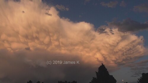
The day ended in Sharon Springs, just in time for a mammatus-filled sunset.


For the first time since late May, I saw a tornado and even though I was not particularly close, I cannot pass up a tornado in August. I've had better luck chasing in Colorado lately, but I think part of that is from learning from past mistakes. Convection often initiates earlier than guidance suggests and that was the case again today. Even though the CAPE/shear parameter space was very impressive for Colorado, as often happens when there's large CAPE in Colorado, storm modes became messy fairly quickly.
All in all, it was an exciting chase and the setup for tomorrow, August 14th, looks very similar. Consider this round one of two.
I watched the first few echoes go up in Yuma County early in the afternoon and decided it was best to stay put, even though I toyed with the idea of possibly targeting the cluster coming out of Nebraska. Needless to say, I did not do that.
A pair of cells evolved into supercell structures with prominent wall clouds, to the southwest of Wray. At first, the northern cell looked dominant, but it suddenly started withering away, giving way to a more classic-looking supercell to the south. I managed to get back to US-385 just in time to dart south and then west on US-36 for a closer look. I watched a tornado from start to finish, even though I was not particularly close. The rough estimate was that the tornado lasted about 7-8 minutes or so and toward the end, there was about a minute with two tornadoes side-by-side. (Low resolution screenshot below)
The initial (main) tornado began to rope out shortly after its twin lifted. I did not manage to stop for any photos, as I was getting rained on pretty hard, power lines were in the way and I was hoping to intercept the storm as it moved south. I have some video (not the best quality), but it does cover the vast majority of the life cycles of the tornadoes.
I chased the storms for a while, but after the initial tornadoes, the setup was generally messy. I closed in on a rain-wrapped, occluding mesocyclone north of Bethune, but with questionable road conditions and very large hail, I got back south to avoid getting stuck or a busted windshield.
It wasn't much later that the storms were throwing out quite a bit of outflow and the tornado potential decreased. I didn't get much footage worth sharing, but I noted several gustnados and/or quasi-landspouts along surging outflow, but most of these features were relatively short-lived.
The day ended in Sharon Springs, just in time for a mammatus-filled sunset.
For the first time since late May, I saw a tornado and even though I was not particularly close, I cannot pass up a tornado in August. I've had better luck chasing in Colorado lately, but I think part of that is from learning from past mistakes. Convection often initiates earlier than guidance suggests and that was the case again today. Even though the CAPE/shear parameter space was very impressive for Colorado, as often happens when there's large CAPE in Colorado, storm modes became messy fairly quickly.
All in all, it was an exciting chase and the setup for tomorrow, August 14th, looks very similar. Consider this round one of two.