kevin-palmer
EF2
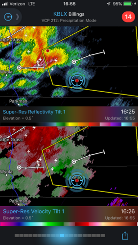
I was going through storm pictures from this year and realized I never posted this on here. For some reason this tornado never made the SPC storm reports even though NWS Billings acknowledged my report. I had planned to drive a lot farther this day, but since the environment started looking better and better close to home I hung back, not leaving until 4PM. This part of Montana (Decker) is very sparsely populated and paved roads or a cell phone signal are hard to come by. I planned to stop at this exact spot next to the coal mine because I knew I could get a signal and check the radar. I noticed the velocity couplet but thought it might be a mistake.

Then I looked up and saw it. The twister started out as more of a cone before becoming q-tip shaped and then roping out after about 5 minutes. While technically I didn't see it touch the ground from my vantage point, it was at least 90% down. Hills, power lines, and high railroad tracks prevented me from finding a better view. A far as I know there were no other reports or pictures.

Decker Tornado by Kevin Palmer, on Flickr
I followed the storm east for a bit and thought I saw another one but hills again blocked my view before muddy roads made me turn back. This is what the terrain is like:

Otter Road by Kevin Palmer, on Flickr
Maybe he could confirm the report.

Buck Looking West by Kevin Palmer, on Flickr
Another cell put on a show back in Wyoming, and had me wishing I had nudged my camera just slightly left.

A Little to the Left by Kevin Palmer, on Flickr

Then I looked up and saw it. The twister started out as more of a cone before becoming q-tip shaped and then roping out after about 5 minutes. While technically I didn't see it touch the ground from my vantage point, it was at least 90% down. Hills, power lines, and high railroad tracks prevented me from finding a better view. A far as I know there were no other reports or pictures.

Decker Tornado by Kevin Palmer, on Flickr
I followed the storm east for a bit and thought I saw another one but hills again blocked my view before muddy roads made me turn back. This is what the terrain is like:

Otter Road by Kevin Palmer, on Flickr
Maybe he could confirm the report.

Buck Looking West by Kevin Palmer, on Flickr
Another cell put on a show back in Wyoming, and had me wishing I had nudged my camera just slightly left.

A Little to the Left by Kevin Palmer, on Flickr
