• While Stormtrack has discontinued its hosting of SpotterNetwork support on the forums, keep in mind that support for SpotterNetwork issues is available by emailing [email protected].

2017-04-29 REPORTS: TX/OK/MO

Myself and a couple buddies chased this day. We stayed the night in Durant, OK. Woke up at 7 and played some golf. Headed southeast afterwards. We were sitting near Sherman, TX when the pre-frontal convection started firing up. We drove east and south as best we could with the sketchy road network SE of Dallas. We ended up getting to HWY 64 just SE of Canton. Terrible sight lines due to trees and hills. Came to a clearing and saw the then wedge coming over the hills to our south. It became apparent we were directly in the tornado's path so we relocated just east as the tornado passed over the highway. We immediately fell back and noticed extensive damage and 2 vehicles thrown into the field north of the road. A pickup was thrown about 1/4 mile north of the road into the field. Myself and 2 friends, and a few other chasers ran out. Guy was trapped inside and in very bad shape, we couldn't get him out and sadly he passed. Jaws of life were on their way to recover. Second vehicle was empty, told by residents it was sitting on a pulloff with a "For Sale" sign on it. Whew. Cleared a couple houses and crated up some dogs that were running about and threw in the towel for the day. Really sobering evening for sure.


Our position pre, and post-tornado:

3d28c5dfa35d5a0c25f9be218e828553.png


As it was heading our direction, we left to the east shortly after:

View attachment 17ce6e791b2be0238a459a870f71b327.jpg


The Jeep that was for sale, this one is probably off the market now. The pickup was down closer to the treelines in the background. :(

View attachment ad363ce5941bbc2ee945d4fc7d89bc13.jpg
 
I missed out on the beastly tornado in the Canton, Texas area on this day. I chose to chase the warm front in Central Illinois instead after an overnight stay in Mount Vernon, IL with Adam Lucio, Alec Scholten, and others. We spent most of the afternoon goofing off and having fun in town at a local brewery, exchanging old chase stories and eventually meeting up with Robert Forry and Ashley Polling. It was great to see so many chaser friends and be able to talk weather for a while. Eventually we slid north toward Vandalia, IL and tornado warnings started popping off to the west. We intercepted the storm east of Pana or just north of Shelbyville, IL where it picked up a tornado warning. It had excellent HP storm structure for most of its life as it rode the warm front. Excellent structure and HP usually don't go together, but it really was quite a beautiful storm. I followed it east to I-57 near Mattoon where it was clear it was going outflow dominant. We eventually got dinner in Champaign joined by Brad Goddard, the rest of the crew from earlier, and my buddy Connor King. We decided to head home toward Galesburg as the next day wasn't looking as good on the models and it would be in our backyard anyway. Here is one shot that I'm pretty proud of that I got of the storm right after it went tornado warned. I love chasing in Illinois.....


aa2dfbfbb169355602bfab847dd068f7.jpg


Not a bad day to be out chasing despite coming home tornado-less..... I was sad about missing such an incredible tornado down south, but even more sad when I heard about all the death and destruction. Anyway....it was a fun outing and I was happy to meet up with so many familiar faces that I haven't seen in such a long time. I can't wait to get back out there.
 
It was a rather intense chase day in eastern Texas. Initially we planned to stay in Greenville and look for storms firing just to the west, but once we saw the cells further southeast we made our way to Mineola to stay on the east side of the storms in hopes of getting a clear view of any circulation. Long story short, we dropped south to get onto TX-64 where we intercepted the second tornado just south of central Canton.

On radar we saw yet another area of intensifying rotation which concerned us. It appeared to be headed towards the same general vicinity as the previous tornado just a bit further east. This storm just seemed to keep producing tornadoes over the same area while slowly sliding northeast... At one point it felt like it was chasing us as we kept heading east on I-20 waiting for the system to weaken so we could reverse course and drive back to Dallas.

It was heartbreaking to see so much damage, and of course hear about the injuries and loss of life.

Can someone confirm if they heard sirens go off in this area? I didn't hear sirens and read an article where a woman said she had little warning.

Not sure if this is acceptable to say on here, but if you're interested in helping out the folks of Canton this is how you can: http://www.redcross.org/local/texas/north-texas/locations/east-texas

Canton-Tornado-2017.jpg
 
Good day all,

I apologize for the late reply but I was on this storm and was quite close to the highly-visible, wedge tornado that passed east of Canton, Texas - And at a rather close range. Below is my full report on this storm.
41309a68b1f3b937ec206a0d2ba841f1.jpg

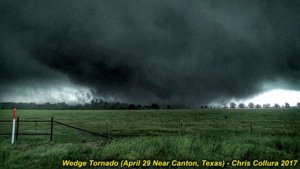
Above: The terrifying mass of fast moving clouds, dirt, and debris churns over an open field and takes aim on the eastern side of Canton, Texas during the late afternoon of April 29, 2017.

Report from chase log: April 29, 6:30 PM - Interception and observation of an extremely severe and violent tornadic thunderstorm in Van Zandt County, Texas from near Tundra along SR 19 and north ands east into Canton and eventually Fruitvale. The storm was violent classic supercell storm, and was the southern storm in a cluster of tornadic supercells. The storm produced a highly visible and well documented wedge tornado just east of SR 19 and northward across I-20. The storm also had a striking visual appearance. The tornado hit parts of Canton and Fruitvale, Texas causing deaths and destruction (probably EF-3 or higher damage). Many homes and businesses, including a car dealership, were completely destroyed. Cars also mangled and flipped. High tension transmission lines were also downed by the tornado with a very loud roar noted. The wedge tornado was 1/2 a mile, and maybe as wide as a mile. Frequent lightning with close hits, isolated hail to golfball sized, torrential rains, and winds gusting over 70 MPH (RFD) were also encountered with this storm. Conditions causing the storm were a prefrontal convergence ahead of a Pacific cold front, low pressure area, upper trough, and surface heating. A 2016 Jeep Wrangler was used to chase the storms. Documentation was digital stills and HD video. A tornado watch was valid for the area until 10 PM CDT.

Video available at the link below (YouTube)...


Pictures of the event are below...
m18tor12.jpg

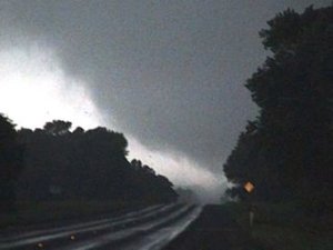
Above: Close-up of tornado core flow crossing Highway 19 (from about one mile to the north) looking southward.
b9675cac52f59505ccd6607add41f9e4.jpg

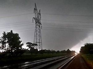
Above: Frightening silhouette of the tornado approaching high-voltage transmission lines. The tornado is widening and intensifying rapidly. The view is south and southeast.
m18tor14.jpg

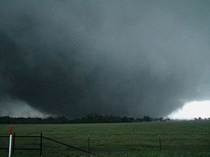
Above: Tornado at about 6:20 PM CDT in wide wedge phase, continuing to the NE and just about to hit the eastern side of Canton, Texas. The view is to the east.
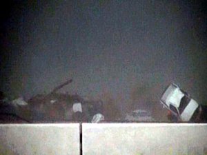
a07b67c3e8c19513b0c705034e0663e9.jpg

Above: View of devastation to the car dealership seconds after the tornado hit on the north side of I-20 at around 6:35 PM CDT.
 
Last edited:
MODS: The video in my last post was "changed" by YouTube for some reason (I was UNABLE to edit my post for some reason)...

The fixed link is below for the 4/29 event...

Video available at the link below (YouTube)...

 
Back
Top