2017-04-10 EVENT: IL/MO

Joined
Aug 9, 2012
Messages
585
Location
Macomb, IL
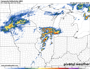
A rather interesting and perhaps surprise event may be setting up across portions of Illinois tomorrow ahead of a cold front/strong low pressure system. Some of the latest HRRR guidance and 3km NAM is showing CAPE values around 3000 J/KG ahead of the frontal boundary tomorrow. Most of the winds ahead of this front look fairly veered however there is an area in West Central to Central Illinois that look to back slightly between 18z and 21z and this coincides with when the HRRR is showing some semi-discrete thunderstorm development in the area in a somewhat favorable environment. I was surprised to see on both the HRRR and the 3km NAM, 0-1km SRH values in the 150m2/s2 range with 0-3km values slightly higher, this was pegging the significant tornado index a little higher ahead of these cells.
e82f77b16d27b50a999caaa23fc79154.png

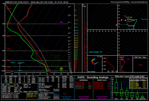
Here is a sounding I pulled around 19z just west of Peoria, IL ahead of that line of cells. Again the wind profile is fairly uni-directional, but there is some low level helicity to work with, especially if we can maintain a semi-discrete storm mode.
2be8084fb3e72a7061633571c6a5a287.png

While obviously not the greatest setup in the world, its worth watching, especially if any overnight convection can leave an outflow boundary which locally backs winds. I've seen days like this that didn't look significant before-hand and turn into a locally significant event because of a couple minor details. One of the more recent events I remember is November 22, 2010. I barely missed a tornado chasing that day, hoping for a repeat tomorrow would be like finding a diamond in a pile of dirt though lol. Regardless, I'll be watching it.
 
Living in far southern/middle Michigan, I hope I can find the time to move to the southwest enough to see something decent. I only follow storms that make it to my backyard and have yet to ever witness a tornado. I don't really expect to see one, but really enjoy when possible severe storms make it this close to my hometown.
 
Looking at data early this morning, its clear to me that not much has changed since my viewing of the models last night. SPC is on board with my thinking and I think this afternoon I'll take a short drive up toward Princeton, IL.
c97f0f2705b59436b6bc21be544d82e8.png

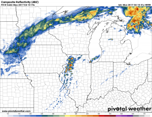
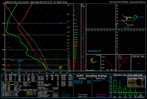
I expect initiation to occur in SE IA/WC IL between 17-19z and then storm maturation as it moves northeast into North Central Illinois by 21z. Winds become slightly backed in this region along with strong instability (2000-3000 J/KG) and high moisture for early April. Here is a sounding I pulled just downstream from the modeled supercell thunderstorm in Bureau County, IL.

2bff8b6b260a63f518a2aa1f377a1504.png

Its looking likely to me that somewhere between my home-town of Galesburg and that region will probably see some type of interesting weather later on today. Whether I see a tornado or not, yet to be determined, but I'm confident in at least a few severe thunderstorms and particularly some pretty large hail given the lapse rates approaching 8 C/KM later today over the target area. Definitely a better setup that I envisioned 24 hours ago, one that I feel has real potential.
 
It looks like more robust convection is trying to form both across northeastern IL, as well as ahead of the main cold front, which presently extends from just east of KIOW to KIRK and points southward. Instability has been tempered a bit by a more filtered sunshine, as ongoing cloud cover has persisted across parts of the warm sector this morning, though pockets of sunshine have contributed to MUCAPE profiles AOB 1000 J/KG, increasing across parts of W and C IL ahead of the main forcing as the better H5 dynamics work into the region. Both the 12z ILX and DVN soundings showed marginal, albeit adequate moisture; a glance at 17z mesoanalysis data is depicting paltrier low level lapse rates, owed partially to mediocre instability, though mid-level lapse rates are more than sufficient for an ice show later.

The cell approaching ORD has already had several 1" hail reports. Surface and VWP data from ILX, DVN and LOT radar sites shows some local southeastern components to surface winds, though with time it appears veering and largely unidirectional flow will come predominate the risk area. That having been said, I wouldn't be surprised to see some local enhancement of near-storm streamwise vorticity profiles augmented by pre-existing mesoscale boundaries from the myriad of forenoon convection that impacted areas of WC, NC and EC IL into N IN at various points this morning. So a few tornado reports are not out of the question, eyeing the best risk across mostly LOTs FA, large hail and damaging wind reports will probably be commonplace too, especially the next 4-6 hours. Forecast skew-T profiles suggest that activity will probably congeal into conglomerate or QLCS modes, and is suggested by 18z+ CAMs too.
 
Back
Top