Scott Kapser
EF0
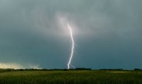
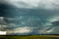
Was only expecting to shoot some lightning this day with weak low-level shear squashing any tornado potential. Got on the storms as they formed west of Devil's Lake, ND and got some good lightning grabs. The southern most storm would waffle back and forth between some weak supercell mode and squalling out. Eventually I noticed a more pronounced velocity couplet forming and soon a hook as well so I moved south for a better look. I was greeted with the most visually impressive storm I have ever seen in Eastern North Dakota. Absolutely incredible HP structure. The storm was not able to maintain this form for very long as the huge, meaty RFD blasted east and eventually northeast into the forward flank of the storm. The storm then exploded into a mess of echoes with a flurry of wind damage reports. All together quite a day, here's my video: