Quincy Vagell
EF4
This almost wasn't a chase day for me, but after looking at data in the morning, I decided to drift north (having stayed in Fort Smith the night before) into southern Missouri to keep both the northern target (E MO into IL) and southern target (conditional N AR threat) in play. I quickly accepted that the Ozarks area in Missouri was not good for chasing at all and just as I thought about calling the chase off, I noticed some towers going up to the south across northern Arkansas.
A line of storms had formed and one cell out ahead of the line that was producing hail and turning right. I knew this would be the storm to go for.
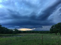
As I got in front of the storm, I found myself in Ash Flat with limited view of the storm's base. After struggling to find a clearing, I stumbled upon one place and got my cameras set up. It was just in time as this mini-supercell was developing a bit of a ragged wall cloud with some scuddy inflow. I shot two prolonged videos, but due to the limited "excitement" of the clips, I have just uploaded a quick time-lapse here:

I stayed in this field for quite a while before the storm was beginning to show signs of weakening. I did shift east momentarily, but it wasn't long after that another mini-supercell formed right behind it. I'm guessing there may have been some remnant outflow boundary or weak convergence line allowing for storms to fire and deviate slightly from the mean flow along the cold front. The second storm very briefly dropped a low, scuddy wall cloud, but due to poor visibility, I had no way of telling if this was a ground-scraping wall cloud or simply one that appeared lower than reality due to the forest canopy. It also can't be overlooked that radar coverage is very poor in north-central Arkansas, so I did not have great data to work with either and relied mainly upon what I could see in the sky.
To the south, a supercell was tornado warned in the vicinity of Conway County. I did not witness this storm, but was watching radar and observations. This was a classic case of locally backed flow in the Arkansas Valley probably contributing for the ability for storms to gain low-level rotation. In Illinois, I saw photos of at least one photogenic supercell. That was closer to the frontal boundary that I considered chasing for the northern target.
Note that SPC dropped the 2% tornado risk for Arkansas after the 13z outlook. The models showed veering low level winds ahead of the cold front, but winds largely remained backed throughout the entire event. (winds in AR went southerly for a while, but by 00z, winds ranged from S to SE across much of central to northeastern AR)
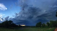
A partial-panoramic shot of the initial supercell. It had a few moments of a lowering appendage, but I did not consider anything that I saw a true funnel cloud.

A line of storms had formed and one cell out ahead of the line that was producing hail and turning right. I knew this would be the storm to go for.
As I got in front of the storm, I found myself in Ash Flat with limited view of the storm's base. After struggling to find a clearing, I stumbled upon one place and got my cameras set up. It was just in time as this mini-supercell was developing a bit of a ragged wall cloud with some scuddy inflow. I shot two prolonged videos, but due to the limited "excitement" of the clips, I have just uploaded a quick time-lapse here:

I stayed in this field for quite a while before the storm was beginning to show signs of weakening. I did shift east momentarily, but it wasn't long after that another mini-supercell formed right behind it. I'm guessing there may have been some remnant outflow boundary or weak convergence line allowing for storms to fire and deviate slightly from the mean flow along the cold front. The second storm very briefly dropped a low, scuddy wall cloud, but due to poor visibility, I had no way of telling if this was a ground-scraping wall cloud or simply one that appeared lower than reality due to the forest canopy. It also can't be overlooked that radar coverage is very poor in north-central Arkansas, so I did not have great data to work with either and relied mainly upon what I could see in the sky.
To the south, a supercell was tornado warned in the vicinity of Conway County. I did not witness this storm, but was watching radar and observations. This was a classic case of locally backed flow in the Arkansas Valley probably contributing for the ability for storms to gain low-level rotation. In Illinois, I saw photos of at least one photogenic supercell. That was closer to the frontal boundary that I considered chasing for the northern target.
Note that SPC dropped the 2% tornado risk for Arkansas after the 13z outlook. The models showed veering low level winds ahead of the cold front, but winds largely remained backed throughout the entire event. (winds in AR went southerly for a while, but by 00z, winds ranged from S to SE across much of central to northeastern AR)
A partial-panoramic shot of the initial supercell. It had a few moments of a lowering appendage, but I did not consider anything that I saw a true funnel cloud.


