John Farley
Supporter
Wild weather in Archuleta County, CO this afternoon and evening. First, an intense isolated cell formed near Navajo Lake and tracked ENE to just north of Dulce, NM and then continuing on through the Chromo, CO area. I intercepted this storm and caught a funnel cloud about 4 miles west of Chromo, looking to the WNW.
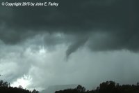
Video of the cloud rotation and funnel:
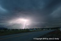
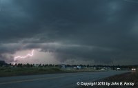
Then around 7:30 another intense storm, which appeared to take on HP supercell characteristics, moved into the Pagosa Springs area, dumping 1.3 inches of rain in an hour. The pictures below were captured with a lightning trigger from just SW of Pagosa Springs as this storm moved in:
When I get a full report written up I will post a link. I knew there was potential today with the jet stream overhead and a good monsoon plume in the area, along with some directional shear, but what we got was well beyond what I expected.

Video of the cloud rotation and funnel:
Then around 7:30 another intense storm, which appeared to take on HP supercell characteristics, moved into the Pagosa Springs area, dumping 1.3 inches of rain in an hour. The pictures below were captured with a lightning trigger from just SW of Pagosa Springs as this storm moved in:


When I get a full report written up I will post a link. I knew there was potential today with the jet stream overhead and a good monsoon plume in the area, along with some directional shear, but what we got was well beyond what I expected.
