2015-05-23 EVENT: TX, OK, KS, CO, NE

Jared Orr

EF1
Joined
Feb 12, 2008
Messages
97
Location
Kansas City
I will go ahead and start a thread for Saturday, since I will likely be able to chase this event. It’s looking like another modest setup in the plains. But “modest is hottest”. Not sure if that applies to weather as much as women. But we’ll go with it.

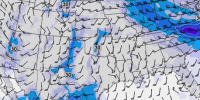
Our models paint a dreary picture for the southern target. Convection ongoing in the morning will limit buoyancy later in the day (as we have been seeing with many other setups), PW is high (approaching 1.8”), 500mb flow rate is dramatically decreased east of the TX panhandle leading to weak anvil relative winds. See below.

11263012_1176120782401867_6573000979369120405_n.jpg


All of this along with little-to-no cap spell out messy storm modes with embedded HPs. For those who “speak SPC”, probably 5% tornado probs for these areas, and not the good kind of 5%.

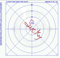
Elsewhere, there is some hope along the dryline in Kansas, with some instability present. But I clicked on this area in Nexlab, looked at the hodograph, and noticed something fascinating...

If you print the SW KS Hodograph and hold it up to a mirror, this is what you will see:


10405344_1176120615735217_8434755538014464381_n.jpg


I wanted to use a different word.

Further north is where my chase team will probably be banking on. After arriving late for all of that “Colorado Magic” a few Saturdays ago --with rainbow-nados and crap-- I swore I would never let 50F dew points and cold mountain air keep me from this region again. I’m still healing.

Joking aside, I really like the fact that there may be a little cap present in this area to hold things off until late afternoon. I also like the backed surface winds along the warm front and the fact that "convective precip" on high res and low res models shows a nice cluster of storms forming along said front in response to surface forcing. A lot of variation exists between the GFS and NAM with regard to where the front will be situated. But if it plays out how I think it will, NE Colorado and W Nebraka will have some tornado reports.

That’s my quick, rough forecast. Now discuss.
 

Attachments

  • upload_2015-5-21_16-6-0.png
    upload_2015-5-21_16-6-0.png
    206.4 KB · Views: 178
  • upload_2015-5-21_16-6-9.png
    upload_2015-5-21_16-6-9.png
    200.7 KB · Views: 174
Let's face it, we're all desperate for a photogenic tornado in the year of the Saturday HPs, so why not chase a marginal setup in Colorado (or Kansas or Nebraska)? After all, given the target area, climatology would favor a day such as Saturday producing tornadoes, sloppy as they may be. My motto this year has become "when it's Saturday, you chase". However, keep in mind I'm mentally prepared for a bust for reasons I will mention and am chasing this one only because it's a Saturday and, well, I'll take what I can get after missing everything last year. I will try to bring the MPAS into my forecast (thanks Jeff) since this will be the first setup I've actually given it a look.

The NAM looks pretty solid with shear trending upwards to 40-45kts in NE CO and CAPE in the 1500-200 range. The CAPE seems reasonable given that neither of the NAMs break off precip until after 21z, and the GFS somewhat agrees with this in its convective precip forecasts for NE CO. There's even (gasp) some capping evident on a lot of the soundings in that area until 4 pm. However, given the warm front moving through, I'd imagine there's going to be some light convection that should hopefully clear up early enough to allow those CAPE values to reach that range. An issue with last Saturday was storm relative anvil winds being relatively low due to the fast moving nature of the storms thanks to unidirectional flow above 700 mb. This doesn't seem to be as much of an issue, as storms should be moving a little slower (25 kts) and anvil level winds are forecast by all models to be on the order of 90-100 kts. However, there is again a VBV profile as well as a noticeable lack of directional shear in the mid levels, which will most likely result in messy storm modes with storms struggling to stay even semi-discrete. The NAM, GFS, and MPAS have the surface low bringing mid to upper 50s dews with it possibly reaching just over 60 as you move eastward into the North Platte area and southward.

I think the biggest strength of this setup is the low level shear. 25 kt surface winds and 850mb winds up to 40 kts is sufficient to enhance low level shear and the warm front moving through backs surface winds enhancing low level directional shear a bit to its south. I also like the timing of the 500 mb trough moving in just after 18z on most of the models, hopefully holding down the stronger, deep convection until we want it. The biggest weaknesses are the marginal CAPE, and if the GFS is right about shear, probably won't even be embedded supercells. On top of that the wind profiles are the exact same as every other setup this year, so I'd imagine it will do the same thing. That is, storms that do manage to stay discrete will only do so for a limited time before they crash into the storm to their north, or until outflow from the storms to their south get vented into them and ruin them. Definitely another tail-end-charlie type of day, similar to last Saturday, just way farther north.

To summarize, I think Sterling, CO is a bullseye target right now. NAM 4km and MPAS have limited numbers of updraft helicities forming right around there, moving northeast. Reflectivity forecasts have them quickly congealing into a big blob. If this verifies, I think there will be a short window of opportunity for Jared and I to get a tornado or two before things get really messy.
 
Last edited:
I like how there is a forecasted -20C slight closed 500 low sitting over the UT/CO border at 18 to 21z. With South to Southwest flow at the mid to upper levels to the right of this low with southeast to almost straight east flow at the surface. Elevation in northeast CO is 4000 feet or so - so dewpoints don't have to be that high and temps don't have to be that high to generate organized deep convection - throw in some boundary level heating and that cooler 500 level and you've got fairly good low level and mid level lapse rates - the kind you're looking for with the EML further east. With increasing 500 mb Bulk shear also looks good in this region too... in fact look a little higher than the 500 mb level to the 400 level and your shear is even better. I think with all the questions in the warm sector - along the dry line in Kansas - this is one of the scenarios that should hold court no matter if convection forms or not. NAM at 18z starts to paint a more unstable picture across Southwest Nebraska (higher surface temps and dewpoints) - but again this is contingent on clearing and the convection that is forecasted in that model to be over Eastern KS... as opposed to further west Central KS messing up the low level flow yet again. Difference in this setup vs. last week's is that the 500 low is progged to be centered further south (believe it was up into WY or MT last week). If I can't find good lapse rates because of lack of heating and convective overturning and cooling, then I'm going to keep looking for that upper low and the elevation to help provide that. Since it's northeast Colorado, It's in an area that if one is going to target... it has to be a full commitment. I'm willing to commit.
 
I strongly agree with the Colorado target, but will not rehash already good reasoning above. Let me just add a few thoughts. Cells could be low top which might help with the VBV situation. Even if not, the nature of Colorado set-ups means you really don't need the traditional severe wx indices pegged out. Don't fret over light 925 mb winds, because ground level is 850 mb and it looks good. The 700 mb wind is also backed slightly/enough for mid-level inflow to storms. While I normally like a little more evidence upstairs, you can't deny the hi-res NAM reflectivity simulation screams rotating supercells in northeast Colorado. Might go early to mid-afternoon, but if you can make it in time, Colorado is my favorite target. Two weeks ago Saturday may be a good comparison.

I believe the OFB south will go too. Although 500-250 mb won't be incredibly strong, 50kt is enough in late May. 850/925 backing is forecast only along the OFB. I'm afraid the DL does not have enough turning away from OFBs. Cell selection will be tough. Go with existing tail-end or hope for new? Then after a cycle or two it could go HP. Finally it may line out. Despite all that I think the south target is chasable. With some luck some contrast may be noted, especially first cycle. Tuesday may be a good comparison.

I like the SPC slight. Maybe drop ENH where the slights were yesterday. Situation is still too conditional for a MDT. Keep in mind holiday through traffic, not even interested in storms, will add to the holiday weekend storm crowds. South target has a big flash flood risk. Be extra safe, and good luck booking tornadoes!
 
I am currently in Midland and not sure the 9-10 hour drive to northeast CO is worth it for me. It doesn't look all that great, and it would be a one-and-done chase too - I don't see much else happening up that way for the next five or six days afterwards. The upcoming week looks pretty crappy everywhere, but whatever chase opportunities do exist look to be back down on the southern Plains. So I may just take my chances in the TX panhandle to southwestern KS on Saturday.
 
I am currently in Midland and not sure the 9-10 hour drive to northeast CO is worth it for me. It doesn't look all that great, and it would be a one-and-done chase too - I don't see much else happening up that way for the next five or six days afterwards. The upcoming week looks pretty crappy everywhere, but whatever chase opportunities do exist look to be back down on the southern Plains. So I may just take my chances in the TX panhandle to southwestern KS on Saturday.
 
Despite my post from yesterday, I have decided to make the trek to CO today - but more southeast CO, as opposed to northeast. Thinking somewhere in an ellipse between Lamar and Limon. Northeast CO appears as if it will remain quite cool today, with temps in the 50s and 60s. I know strange things can happen in the cold air in CO, but I am not willing to bank on that today. I like the temps, moisture and CAPE better in southeastern CO. Think it is going to be an early show though. Better 500mb flow will shift east into KS as flow in CO weakens and becomes more meridional by 0Z as the mid level low drifts westward. 250mb is already meridional but I can live with that more so than meridional 500mb; and at least the 250mb flow is strong. Pueblo AFD seems quite bullish on severe potential.

Actually was looking at the TX panhandle as a potential target. Despite the morning storms, models showed moisture remaining and a dryline sharpening. CAPE adequate though not great. And more southwesterly component to the 500mb winds. But seeing that SPC removed the region from the Slight Risk changed my mind. I don't just chase SPC risk areas, I always do my own forecast first to avoid any confirmation bias. But at the end of the day, I am not confident enough in my amateur forecasting skills to make a targeting decision that conflicts with the experts' analysis.

Jim
 
Parameters near nebraska are not really as encouraging as we saw in earlier model runs. Honestly, we know that 500 J/KG can do it under the right circumstances, but aiming for something closer to E central Colorado just feels like the right thing to do for multiple reasons:
-Greater chance of cloud deck clearing in this area.
-The clearing and higher surface moisture will lead to better buoyancy
-Convective models show potentially isolated cells in this area
-With the surface low situated in S-Ctrl CO, backed surface winds will not be lacking in this area (similar to further north)
-Upper level bulk shear is more robust the further south and east that you go in CO

So we will be targeting somewhere between Punkin Center and Fowler, CO and then waiting for real-time data to fine-tune our target.
 
Models are coming around to supporting recovery in the far Western TX Panhandle into NE NM later this afternoon, in addition to being supported by the latest HRRR. Will target I-40 north to SE Colorado. As always, an assortment of AM boundaries will enhance the potential later this afternoon.

W.
 
Looking at CIPS guidance and seeing persistent clearing up to Limon, I think we may just camp up here in Limon for a while until things become more evident.
 
Last edited:
Noticed how juicy things are looking west of Plainview / Lubbock area. Sure enough, 17:30 SPC now extends the Slight Risk area westward as compared to 13:00's outlook. To Warren's point, overnight models did not reflect recovery that far west but now they have come around. Second guessing my Colorado target decision but it's too late now. Stopped for lunch in Lamar and will continue west and north from here. Currently, backed winds and >50 dews are limited to the latitude of Lamar but I am sure that will change.
 
Back
Top