2015-04-25 EVENT KY/TN

Joined
Jan 20, 2015
Messages
26
Location
Saint Louis, MO
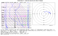
Northern Dixie for Saturday The potential for severe storms is still very evident per latest NAM. Right now my target is the Bowling Green area. 12Z NAM forecast sounding out of KBWG at 21Z pushed my target area from TN to KY. Not the best directional shear, but it is enough, especially with nearly 4000J/kg of CAPE and more than enough speed shear.

First time starting one of these threads, but I really don't have much else to elaborate on other than I like this sounding and parameters, it's close to the surface low and warm front,and it is only an hour and a half away from home. And forecast storm motion is only 40kts. That is pretty slow in this area! No rockets needed to chase tomorrow.
upload_2015-4-24_13-29-10.png
 
Central Kentucky looks like it's gonna be lit up. Heard some comparisons to 2012-03-02 so that could be interesting.

I'm gonna be on a hair trigger in Elizabethtown and watching closely. Etown gives me great access to the main roads in any direction so when thing start firing I can go.
 
I'll be chasing tomorrow, just haven't decided on a target area yet. I'm going to wait and see what happens to the surface low. It seems like with every midwest setup in the past the surface low has ended up much further west than models predicted in the days prior, so I wouldn't even be surprised if southern IL gets the brunt of the action tomorrow. Anyway, basically my target will be just southeast of the surface low along the warm front. Any storm that rides the boundary will have enhanced SRH in an environment already conducive to rotating storms. The directional shear doesn't look like much when you see the veered surface winds, but considering SE storm motions and significant speed shear with around 60 kts at 500mb, it's certainly enough for strong tornadoes. This setup actually reminds me of the northern IL day a couple weeks ago. With 35 kt storm motions and a poor road network, it's going to be a challenge.
 
So, question for you all. I'm heavily considering making a trip to KY tomorrow. I've never chased KY, for those of you who have, is it worth it? I went to college in southern IL, and have been down through Paducah... I'm not sure it'd be even decent terrain?? Anyone have first hand experience down there?
 
Best tip I can give anyone chasing these areas...study google maps....both in terrain mode and satellite mode. Parts of central-southcentral KY are relatively good...from Bowling Green south to the TN line and west to Hopkinsville. Areas east get pretty hilly and tree coverage increases.
 
So, question for you all. I'm heavily considering making a trip to KY tomorrow. I've never chased KY, for those of you who have, is it worth it? I went to college in southern IL, and have been down through Paducah... I'm not sure it'd be even decent terrain?? Anyone have first hand experience down there?

Having cut my teeth in the Central KY area my main warning for you is that there are several areas that have little to no visibility due to trees, hills, and towns. If you can't analyze a storm and spot features with a limited view point you could be wasting your time. The road network is hit or miss depending on where the storm forms and where it heads, sometimes you can find little shortcuts and such, but you can also get lost easily and end up nowhere near the storm. I don't want to discourage you from chasing the area (bit of a coincidence my last chase took me to your neck of the woods) but don't expect it to be as easy as IL can be and the Alley can be. This area is frustrating to chase and can turn the best setups into a QLCS mess. But on the bright side when you DO get a tornado you have it pretty much to yourself. There's no such thing as a chaser convergence around here, you just have to find the one position that lets you see the tornado without having your view obstructed by something.

And as Ashley said, study google maps and learn as many roads and features as you can.
 
With the triple point over my own house, I could probably just set up a lawn chair and wait!
Seriously though, this looks to be a producer of "something" in my opinion, the last time I saw a set up like this around here was in 2012 (CAPE was only 1300 that day) and we saw an EF1 in Elkville, Illinois and an EF2 in Opdyke, Illinois that resulted in one fatality. The sun was shining and was a perfect day for grilling...then out of nowhere the ground was covered in small hail and spin ups of funnels began in Murphysboro. Given the start of the day, I pretty much wrote it off as nothing. I still managed to get a late chase in that got me a whole 6 seconds of the funnel retreating, in slow motion you could see it. I had actually considered deleting that video, but viewing it in slow motion, I saw it and a small wall cloud.
Tomorrow will be interesting.
 
I will be going on my second chase tomorrow. Attended a Skywarn Spotter Training course last week and have purchased better equipment for filming and navigation. Once again like 4-09 I have work the next day and I will be about 6 hours away from home. Going to be targeting the warm front. Going to get down to I64 West of the Evansville area and evaluate things. Probably will be pushing into Southern Illinois. Giving my inexperience Kentucky is out of the equation for me tomorrow. Good luck fellow chasers and stay safe!
 
Back
Top