2014-06-07 REPORTS: IL/MO/TN/KY

Joined
Jan 14, 2011
Messages
3,340
Location
St. Louis
I learned quickly after moving to the Midwest never to ignore MCVs or surface lows here. I observed two tornadoes in the St. Louis metro area today with supercells that fired in the southeast quadrant of a remnant MCV from last night's storms on the Plains. The MCV managed to entrain surface-based instability behind an earlier line of convection that cleared out by mid-afternoon.

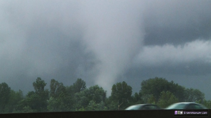
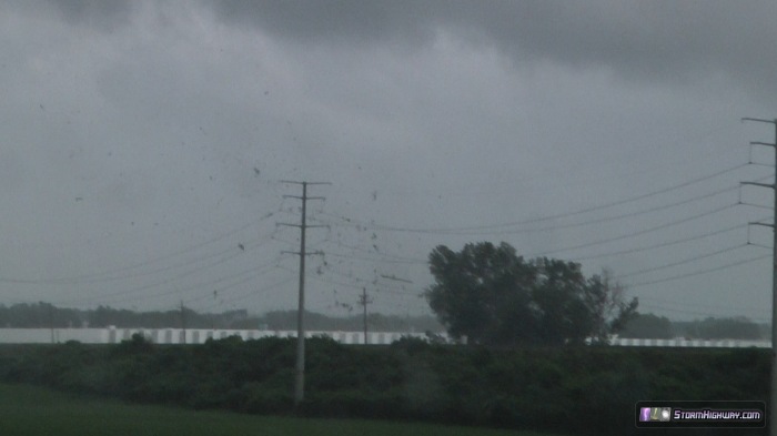
I caught the first tornado at the intersection of Highway 370 and Earth City Expressway east of St. Charles. The wall cloud was wound up tight and produced intermittent vortices on the ground as it approached from the south. The tornado hit an area of industrial warehouses south of 370 with debris flying, then crossed the highway and eventually became fully condensed for a brief time. A Southwest Airlines 737 jetliner on approach to Lambert Airport passed directly through the tornado circulation, with the aircraft visibly rolling to the left briefly.

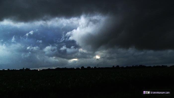
I caught the second tornado between Highland and Trenton, Illinois with another low-topped storm. This tornado was never fully condensed, but had periodic ground circulations visible as debris/spray on the wet fields. It was essentially the size/intensity of a dust devil at the ground. Since this tornado was very weak, I approached it and let it cross within 10-20 feet of my vehicle. You can see the circulation move through the corn on the right side of the road in my dashcam video (linked below).

Video grabs:

Tornado impacting industrial warehouses south of Hwy 370:
june714tor1bt.jpg


Fully condensed north of 370:

june714tor1at.jpg


Second tornado south of Highland, IL:
june714tor2at.jpg


Video links:

First tornado: https://www.youtube.com/watch?v=bsACwJkp0CI
Second tornado: https://www.youtube.com/watch?v=CXSOtkhRut0
 
Last edited by a moderator:
i also caught the same tornado along 370, in fact we got passed by the same vehicles in our videos. I left to chase from work, so just had a cell phone on me. Had originally planned to catch the cell as it passed over Weldon Springs on 40, but fell back and waited for a different cell to fire closer to 270 and 40. Then had to run north. When I briefly entered into st. charles on 370, the broad circulation was super low to the ground, less than 500 feet. I then headed back east and caught the spin ups from the expressway exit before following the tornado on 370. I had actually been on the phone with chris higgins talking about the first signs of rotation so I couldnt get any video there. Very interesting little set up and was nice to be able to get close Here is my crappy video:

https://www.youtube.com/watch?v=weU5xMXe18Y&index=3&list=HL1402201527
 
70's dews, a surface low and a shortwave trough kicking through? I didn't see that coming, but that's a chase in Illinois. Low topped little showers were about all we could manage in the wake of the morning MCS and about 1000 J/Kg MLCAPE. It was enough though!

Ran south down 55 out of Springfield, IL just hoping to catch something semi discrete with an updraft base. I intercepted a 30-40 dbz rain shower near Livingston, IL. It had a decent pendent shape on base reflectivity, so I figured what the heck this might look interesting. Wow, did it! I was surprised to see a ground scraping wall cloud with well defined tail cloud come into view out of the rain.

10417659_755695247784271_7577237126054914327_n.jpg


You could have reached up and high fived that wall cloud it was so low.

This thing was twisting like taffy, in what looked like a mix of cold outflow debris being stretched by the updraft, and warm, moist inflow based lowering. It was probably both. The cell was confined to such a small area, a lot was happening in one tiny place.

So this is scud being pulled like taffy, or it's brief funnel:

10455127_755695257784270_4897309338731869507_n.jpg


That cell rapidly disintegrated shortly after that photo, so I left it for Tail End Charlie between 64 and 70, the one Dan and John scored a tube on. I couldn't get down there in time, however, and watched from the west as that cell drifted east and dissolved. Just to give you an idea of how small these little schnibs were, here's the entire storm, no anvil, just a nice little white lowering on the back end and a precip core that shows up as a yellow dot on the radar:
10456463_755695241117605_2812875098345482066_n.jpg


I followed this thing all the way to Carlyle Lake and let it go there. At about this time Springfield goes tornado warned for some embedded cell in a thick band of rain. Cue the Darth Vader "Noooooooo!"

Another cell north of Saint Louis picked up a tornado warning. I was heading for home now but on a direct intercept course for this cell. The warning was dropped long before I got to it, and the cell was rapidly shriveling on the radar. The sun was setting though, so I figured I could setup for a sunset convection time lapse in the wake of the storm. I made it back to Livingston where my chase fun had begun and this ragged flanking line extending south of the tiny cell's updraft came into view:

10427993_755695244450938_168702473626365281_n.jpg


There was a line underneath it. I stared at this for quite a bit before I could convince myself I was looking at a thin as a thread funnel. The cell was so small and unwarned, that I couldn't believe it had any sort of tornado potential.

10392443_755695251117604_7752326547874508864_n.jpg


The condensation funnel dipped as low as the tree line, and that's good enough for me to call it a tornado. I still couldn't believe it though and checked my camera's LCD twice before I hit the button on a tornado report on Spotter Network.

1601515_755695227784273_378564686584204791_n.jpg


I chased the cell east but that brief tornado was the last bit of breath the updraft had in it. The sun dipped below the base and I stopped to shoot some colors in the sky. Outside of the van, I couldn't believe how warm the air was. The storm was now just a green blob, but there was very warm moist inflow being pulled into the updraft base. Dews at about 70 degrees and temps in the mid 70's made for muggy air at the surface. I was surprised at how rich the air was as this was now the third cell to track through the area after my first intercept with the wall cloud and the morning MCS. The airmass remained unstable with rich moisture.

10405648_755695237784272_4613429416209443262_n.jpg


I had no discernible structure at this point, just flanks of convection fanning out everywhere, so I called it a chase and headed for home.

Gorgeous evening skies over Illinois top off an impromptu chase that far exceeded all expectations.

10295721_755695267784269_7553186485185320190_n.jpg
 
After months and months, I finally found time to put together the timelapse for this day in eastern New Mexico (trying new workflows for color correcting gigs of images). This was our last day of our first ever chase vacation. Was a very nice change to finally see some supercells in NM after 3 years of living here in ABQ. The particular sup just southeast of Tucumcari was sooo close to putting down a tornado.

Watch video >
I'm also curious if anyone can describe what happens in the final timelapse shot at 3:48 as it gets dark. Was the storm base decoupling from the PBL and going elevated?
 
Back
Top