*This is my first Target Area post. Please advise if I have not posted appropriately. Judging by the rules and other examples I think I'm ok.
I'm chasing consecutive low risk days that I feel are worthwhile this year as well as moderate setups since there has been so little weather. I chased Nebraska on 6/21 with no great result, so I was really hopeful that Saturday would be better.
Started Saturday 6/22 in Rapid City SD. Visited Mt. Rushmore to kill some time in the morning, but maybe wasted a bit too much time driving around in Custer National Park. First storms initiated west of Casper, Wyoming in early afternoon, and I was hustling to make up time and get over there. By maybe 3PM I was near the Wyoming border on US16 westbound. One storm stayed isolated just east of Casper and was issued a tornado watch based on radar indicated rotation. At this point I lost data (thanks Verizon) for about an hour as I left US16 onto US85 south for Lusk, WY. Had never driven that area before and all I could do was proceed based on previous storm tracks and hope to get some data. When I came back into data range, the storm I had been headed for had started to merge with developing storms in a line to the north and looked like a rain/hail mess. A developing storm further south had set down a confirmed brief tornado roughly southwest of Wheatland, WY. Other various cells had popped up all over during my data blackout and were organizing into a mesoscale mess moving vaguely east northeast, which I had kind of expected to happen before to long. I headed for the south end of the growing mess, as it had radar indicated strong rotation.
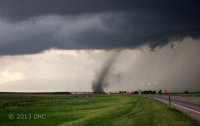
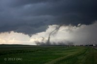
Long story short, it took me a couple hours (with a stop to get gas and handle a camera battery problem, and one construction delay) to get down to the tail storm I wanted. At this point it was becoming 'one of those chases' where things just weren't working out weather or road wise, but when I got there it still looked pretty good with rotation and a recently expired tornado warning. I got a little more excited when I wrapped around behind the storm and pulled along side it. I was on I-80 eastbound near Dix, Nebraska about 6:45PM, checking out this little beast, looking at some nice lowering to my immediate left/north and impressive lightning. Quite suddenly off to my immediate right not far from the interstate at all I saw what looked like a gustnado. Sure enough as I watched, there were two gustnados and I realized I was seeing two vortices on a developing tornado, with the funnel base probably almost overhead! Hit single lane construction with cones on both sides of the lane right at that moment. Argghhhh! Was able to pull off safely about two miles up the interstate and photograph what was a beautiful little tornado - on the ground for maybe 8 minutes. It crossed northeast over I-80 once (when my photos start) and back to the south side before dissipating. No damage or injuries I am aware of, thankfully. Still trying to decide if this was a good landspout or weak supercell tornado. It was under the updraft base/meso, but sure looked spoutish to me through most of its lifecycle. Followed up the tornado with some sunset photos as I headed south From Sydney, NE to Sterling, CO. then home to Denver. Ended up being a wonderful Saturday for me after a lot of work. Chase photos below:
[Broken External Image]:https://sphotos-a.xx.fbcdn.net/hphotos-ash3/1063876_858398975618_822581919_o.jpg
Mt. Rushmore

Finally under the supercell I'd been after for over an hour.

[Broken External Image]:https://sphotos-a.xx.fbcdn.net/hphotos-prn2/1063768_858398900768_1194956201_o.jpg
[Broken External Image]:https://sphotos-a.xx.fbcdn.net/hphotos-prn1/1040027_858398905758_1467424886_o.jpg

[Broken External Image]:https://sphotos-b.xx.fbcdn.net/hphotos-ash4/1048408_858398910748_341843063_o.jpg
Finish strong with some sunset photos.
[Broken External Image]:https://sphotos-a.xx.fbcdn.net/hphotos-frc3/977987_858398950668_388136992_o.jpg
Mammatus on the NE/CO border, dropping south for my return to Denver.
I'm chasing consecutive low risk days that I feel are worthwhile this year as well as moderate setups since there has been so little weather. I chased Nebraska on 6/21 with no great result, so I was really hopeful that Saturday would be better.
Started Saturday 6/22 in Rapid City SD. Visited Mt. Rushmore to kill some time in the morning, but maybe wasted a bit too much time driving around in Custer National Park. First storms initiated west of Casper, Wyoming in early afternoon, and I was hustling to make up time and get over there. By maybe 3PM I was near the Wyoming border on US16 westbound. One storm stayed isolated just east of Casper and was issued a tornado watch based on radar indicated rotation. At this point I lost data (thanks Verizon) for about an hour as I left US16 onto US85 south for Lusk, WY. Had never driven that area before and all I could do was proceed based on previous storm tracks and hope to get some data. When I came back into data range, the storm I had been headed for had started to merge with developing storms in a line to the north and looked like a rain/hail mess. A developing storm further south had set down a confirmed brief tornado roughly southwest of Wheatland, WY. Other various cells had popped up all over during my data blackout and were organizing into a mesoscale mess moving vaguely east northeast, which I had kind of expected to happen before to long. I headed for the south end of the growing mess, as it had radar indicated strong rotation.
Long story short, it took me a couple hours (with a stop to get gas and handle a camera battery problem, and one construction delay) to get down to the tail storm I wanted. At this point it was becoming 'one of those chases' where things just weren't working out weather or road wise, but when I got there it still looked pretty good with rotation and a recently expired tornado warning. I got a little more excited when I wrapped around behind the storm and pulled along side it. I was on I-80 eastbound near Dix, Nebraska about 6:45PM, checking out this little beast, looking at some nice lowering to my immediate left/north and impressive lightning. Quite suddenly off to my immediate right not far from the interstate at all I saw what looked like a gustnado. Sure enough as I watched, there were two gustnados and I realized I was seeing two vortices on a developing tornado, with the funnel base probably almost overhead! Hit single lane construction with cones on both sides of the lane right at that moment. Argghhhh! Was able to pull off safely about two miles up the interstate and photograph what was a beautiful little tornado - on the ground for maybe 8 minutes. It crossed northeast over I-80 once (when my photos start) and back to the south side before dissipating. No damage or injuries I am aware of, thankfully. Still trying to decide if this was a good landspout or weak supercell tornado. It was under the updraft base/meso, but sure looked spoutish to me through most of its lifecycle. Followed up the tornado with some sunset photos as I headed south From Sydney, NE to Sterling, CO. then home to Denver. Ended up being a wonderful Saturday for me after a lot of work. Chase photos below:
[Broken External Image]:https://sphotos-a.xx.fbcdn.net/hphotos-ash3/1063876_858398975618_822581919_o.jpg
Mt. Rushmore

Finally under the supercell I'd been after for over an hour.

[Broken External Image]:https://sphotos-a.xx.fbcdn.net/hphotos-prn2/1063768_858398900768_1194956201_o.jpg
[Broken External Image]:https://sphotos-a.xx.fbcdn.net/hphotos-prn1/1040027_858398905758_1467424886_o.jpg

[Broken External Image]:https://sphotos-b.xx.fbcdn.net/hphotos-ash4/1048408_858398910748_341843063_o.jpg
Finish strong with some sunset photos.
[Broken External Image]:https://sphotos-a.xx.fbcdn.net/hphotos-frc3/977987_858398950668_388136992_o.jpg
Mammatus on the NE/CO border, dropping south for my return to Denver.
Last edited by a moderator:


