• A friendly and periodic reminder of the rules we use for fostering high SNR and quality conversation and interaction at Stormtrack: Forum rules

    P.S. - Nothing specific happened to prompt this message! No one is in trouble, there are no flame wars in effect, nor any inappropriate conversation ongoing. This is being posted sitewide as a casual refresher.

2013-05-20 Moore Oklahoma EF5

Michael Towers

Supporter
Joined
Jun 28, 2007
Messages
359
Location
Machesney Park, IL
Just posted by NOAA Weather Partners and presented by SPC forecaster Chris Broyles, a fascinating re-creation of the life cycle of the supercell and tornado utilizing animations and radar from 90 minutes prior to tornadogenesis to dissipation:


A major influence on both tornadogenesis and the evolution of the tornado is attributed to Descending Reflectivity Cores (DRC) which is a distinct form of downdraft occlusion that I found very interesting. Links to this subject and also links from the presentation:


From a chasing perspective, I am still not over having mis-targeted this day. I’m not the only one, as many (if not most) other chasers were further southwest near Duncan OK. But what really bothers me is that SPC issued a mesoscale discussion with a graphic confirming the triple point was right where I was forecasting/targeting. Combined with the fact that I also failed to be in the right place at the right time for the Duncan tornado, and that this day was right in the middle of an epic string of failures that failed to capitalize on an incredible two-week stretch at the end of May, and ten years later I am still trying to redeem myself!
 
From a chasing perspective, I am still not over having mis-targeted this day. I’m not the only one, as many (if not most) other chasers were further southwest near Duncan OK. But what really bothers me is that SPC issued a mesoscale discussion with a graphic confirming the triple point was right where I was forecasting/targeting. Combined with the fact that I also failed to be in the right place at the right time for the Duncan tornado, and that this day was right in the middle of an epic string of failures that failed to capitalize on an incredible two-week stretch at the end of May, and ten years later I am still trying to redeem myself!

Don't beat yourself up too badly. Most, if not all of the research teams also picked the southern option, specifically, CSWR. We would have DOW data from the Moore tornado if that southern option wasn't as juicy. Most we have now DOW data related is the tornado itself from many miles away, and data from a stationary research radar near the ROC in Westheimer.
 
From a chasing perspective, I am still not over having mis-targeted this day. I’m not the only one, as many (if not most) other chasers were further southwest near Duncan OK. But what really bothers me is that SPC issued a mesoscale discussion with a graphic confirming the triple point was right where I was forecasting/targeting.

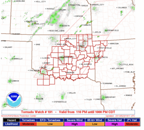
Don't feel too bad. Take a look at the risk of ≥F-2 tornadoes attached to the applicable tornado watch.

My blog posts stating that weather science has little to no skill at nowcasting tornado intensity get a lot of flack but I don't see much evidence that consistent skill exists. 20 may.png
 
Watched the longer ver.
Interesting stuff.

Don't remember hearing about DRC's before this.
Maybe sometime when I have more time & feel like it, I'll read some of the linked documents..
 
It was crazy. The streets were deserted. Perfect road network. It would have been a dream come true if nobody had been hurt. It was really awful to watch.

I was on it because by then I had grown truly sick of driving. I was working in Norman and went out when I saw the storm initiate.

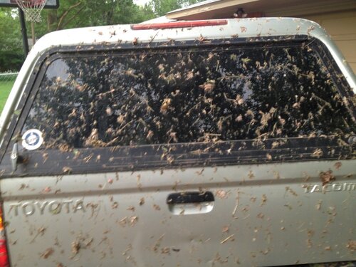
I was on 19th street in Moore. I watched it cross the river and come right at me. I got as close as I dared. My truck was covered in globs of mud and pink insulation afterwards. Two flat tires. I had been really close to tornadoes before, but this was a whole new category of freaky. Be careful what you wish for…
 

Attachments

  • 98AEAC22-7BB8-49C8-A4ED-DBCD06DBB168.jpeg
    98AEAC22-7BB8-49C8-A4ED-DBCD06DBB168.jpeg
    208.8 KB · Views: 1
I hope there are more animations of historic events like this---the little Los Angeles tornado---and the Oak Grove event of 1998.
 
That’s very interesting. I hope it sheds light on why that tornado was so strong, while that strong storm to the south didn’t do much, despite being the superior storm, at a glance.

I wonder if that southern supercell data could be compared to the Moore storm. I heard that the mobile radars were down there

Of course this storm has a very fine scale history from both damage survey and video.

Glad that this was looked at!
 
Back
Top