cdcollura
EF5
Good day all,
May 22 of 2004 was another notable tornado outbreak / event. Two distinct supercell clusters developed along a warm-front / boundary and dryline bulge. One was near Mc Cook, NE and the other SW of Lincoln, NE, including the supercell that affected Hallam, NE with an F-4 (old scale) tornado at an astonishing 2.5 mile width!

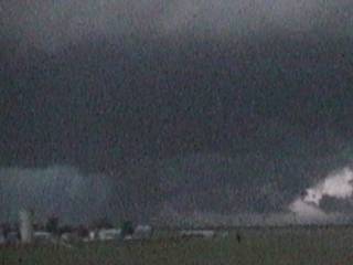
Above: Possible large (wedge) tornado southwest of Hallam, NE (before widening / strinking the town 10-15 minutes later) illuminated by lightning. This tornado / tornado cycles had a length of over 50 miles.
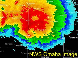
Above: Radar image ... Tornado is the "hook" to the lower left part of the supercell near Wilbur, but also note the "vortex hole" in the HP storm. This was about the time the first annotated image (above this one) was taken.
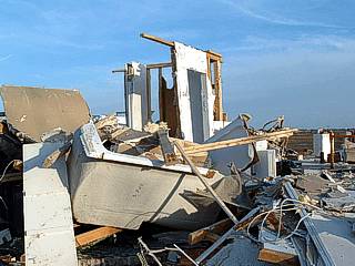
Above: Damage in Hallam, NE on May 23 during damage survey. This WAS a two-story home!

Above: Large color-TV in roadside ditch, about a MILE away from any homes (or what was left of them). Anything in an F4 tornado (note, this was 2004, using the old F4 scale of 205-260 MPH) becomes airborne in the debris flow, even large appliances / vehicles.
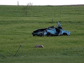
Above: Mangled pickup truck "deposited" in a field, about a half mile from any homes.
A full chase log on my account for May 22, 2004 can be seen in detail at the link below.
http://www.sky-chaser.com/mwcl2004.htm#MAY22
A short description of my log can be read here (below)...
May 22 - Outbreak and high-risk chase day in south-central Nebraska. Today was an extremely volatile and dangerous setup. We left Schulyer, Nebraska and headed south stopping in York to look at data and await break of the capping inversion. During initiation, we headed west on I-80 towards highway 281 and headed south as a line of storms fired to the southeast of on-going convection to our west. We headed east on highway 6 east of Hastings to intercept the storm and had to back out because the storm split and golfball sized hail began hitting us. We headed back west, then south to highway 4 to go back east. The southern split storm became a monster tornadic supercell producing multiple large tornadoes. A large wedge type tornado occurred south of the storm core, and was observed very faintly from behind the storm headed east. Damage was observed along the way (tornado path), including a demolished two story house! After that, we navigated along back-roads to get to the southeast side of the supercell. Several funnels were observed and another large wedge type tornado (possibly?) to the northeast of Beatrice, Nebraska along highway 77. Sure enough, a small town northeast of Beatrice (Hallam) had severe damage according to preliminary reports. We spend the night in Beatrice after all activity passed on to our east. Damage assessment required tomorrow ...
May 22, 7:30 PM - Interception and observation of an EXTREMELY severe, tornadic, and dangerous supercell thunderstorm from east of Hastings, Nebraska to north of Beatrice, Nebraska. This storm was a monster supercell thunderstorm that began as a classic supercell and evolved to an HP supercell at least 30 miles across. The storm produced at least 6 cyclic tornadoes. The first was a large wedge barely visible west of the storm (we were too late because we aborted a northern divert around the core of the supercell). The tornado path was crossed where power poles were snapped, grass scoured off the hillside, irrigation equipment was mangled, and worst of all, a two-story house was ripped apart by the previous tornado. The storm produced inflow winds up to 60 MPH even 5 miles to the southeast of the storm. The storm had hail to 4 inches (but only sporadic golfball sized hail was seen as we tried hard to avoid the core at all costs). Lightning was continuous. Multiple funnel clouds formed around the storms RFD flank. The supercell acquired a full "stacked plate" appearance, but this time, it stretched across the entire sky. A large wedge-type tornado (possibly) was observed about 15 miles northwest of Beatrice as the storm passed by. A faint, low roaring (train) sound was noted with this feature. Later, preliminary reports of damage came in from that general area, which we were only a mile or so away from at the time of the possible tornado! This storm was part of a severe weather outbreak caused by a dryline punch, upper air support (jet stream and wind shear), strong low pressure system, and intense surface heating. Documentation was still photos, a camcorder, and audio. A PDS (Particularly Dangerous Situation) tornado watch was also in effect for this area until 11 PM CDT.
May 23 - Today we took a day off from chasing and spent an extra day in Beatrice, Nebraska to do vehicle maintenance and repair damage to the Weatherlab III weather station. After taking care of some minor issues, we decided to go with BNVN manager Doug Kiesling to survey the damage in Hallam and verify the tornado track. The damage swath was a MILE WIDE in some places, and a depressing scene of destruction loomed over what little was left of the town of Hallam. 95 percent of the town was totally disintegrated! We documented the damage with permission from authorities / residents and left due to the 8PM curfew. Tomorrow may be another chase day so we spent another night in Beatrice.
EDIT: I found this rather interesting read (a small snippet from it and the link to the story is below)...
"A 23-year-old bank receipt from Hallam, Nebraska turned up in Papillion 30 minutes after the tornado leveled the Lancaster County town 73 miles away Saturday night."
http://www.wowt.com/news/headlines/789817.html
Another estimate says the receipt / check traveled the 72 miles in 26 minutes ... Wow - Probably got lofted in the tornado, rode the high-velocity-core (150+ MPH updraft) to jet-stream level (2-3 minutes to 30,000+ feet), then (assuming 200+ MPH jet stream at 3.5 miles per minute), it should have reached 72 miles out in about 20 minutes. The remaining time should be the check "leafing" it's way back to earth (or faster if frozen in ice?)
May 22 of 2004 was another notable tornado outbreak / event. Two distinct supercell clusters developed along a warm-front / boundary and dryline bulge. One was near Mc Cook, NE and the other SW of Lincoln, NE, including the supercell that affected Hallam, NE with an F-4 (old scale) tornado at an astonishing 2.5 mile width!
Above: Possible large (wedge) tornado southwest of Hallam, NE (before widening / strinking the town 10-15 minutes later) illuminated by lightning. This tornado / tornado cycles had a length of over 50 miles.
Above: Radar image ... Tornado is the "hook" to the lower left part of the supercell near Wilbur, but also note the "vortex hole" in the HP storm. This was about the time the first annotated image (above this one) was taken.
Above: Damage in Hallam, NE on May 23 during damage survey. This WAS a two-story home!
Above: Large color-TV in roadside ditch, about a MILE away from any homes (or what was left of them). Anything in an F4 tornado (note, this was 2004, using the old F4 scale of 205-260 MPH) becomes airborne in the debris flow, even large appliances / vehicles.
Above: Mangled pickup truck "deposited" in a field, about a half mile from any homes.
A full chase log on my account for May 22, 2004 can be seen in detail at the link below.
http://www.sky-chaser.com/mwcl2004.htm#MAY22
A short description of my log can be read here (below)...
May 22 - Outbreak and high-risk chase day in south-central Nebraska. Today was an extremely volatile and dangerous setup. We left Schulyer, Nebraska and headed south stopping in York to look at data and await break of the capping inversion. During initiation, we headed west on I-80 towards highway 281 and headed south as a line of storms fired to the southeast of on-going convection to our west. We headed east on highway 6 east of Hastings to intercept the storm and had to back out because the storm split and golfball sized hail began hitting us. We headed back west, then south to highway 4 to go back east. The southern split storm became a monster tornadic supercell producing multiple large tornadoes. A large wedge type tornado occurred south of the storm core, and was observed very faintly from behind the storm headed east. Damage was observed along the way (tornado path), including a demolished two story house! After that, we navigated along back-roads to get to the southeast side of the supercell. Several funnels were observed and another large wedge type tornado (possibly?) to the northeast of Beatrice, Nebraska along highway 77. Sure enough, a small town northeast of Beatrice (Hallam) had severe damage according to preliminary reports. We spend the night in Beatrice after all activity passed on to our east. Damage assessment required tomorrow ...
May 22, 7:30 PM - Interception and observation of an EXTREMELY severe, tornadic, and dangerous supercell thunderstorm from east of Hastings, Nebraska to north of Beatrice, Nebraska. This storm was a monster supercell thunderstorm that began as a classic supercell and evolved to an HP supercell at least 30 miles across. The storm produced at least 6 cyclic tornadoes. The first was a large wedge barely visible west of the storm (we were too late because we aborted a northern divert around the core of the supercell). The tornado path was crossed where power poles were snapped, grass scoured off the hillside, irrigation equipment was mangled, and worst of all, a two-story house was ripped apart by the previous tornado. The storm produced inflow winds up to 60 MPH even 5 miles to the southeast of the storm. The storm had hail to 4 inches (but only sporadic golfball sized hail was seen as we tried hard to avoid the core at all costs). Lightning was continuous. Multiple funnel clouds formed around the storms RFD flank. The supercell acquired a full "stacked plate" appearance, but this time, it stretched across the entire sky. A large wedge-type tornado (possibly) was observed about 15 miles northwest of Beatrice as the storm passed by. A faint, low roaring (train) sound was noted with this feature. Later, preliminary reports of damage came in from that general area, which we were only a mile or so away from at the time of the possible tornado! This storm was part of a severe weather outbreak caused by a dryline punch, upper air support (jet stream and wind shear), strong low pressure system, and intense surface heating. Documentation was still photos, a camcorder, and audio. A PDS (Particularly Dangerous Situation) tornado watch was also in effect for this area until 11 PM CDT.
May 23 - Today we took a day off from chasing and spent an extra day in Beatrice, Nebraska to do vehicle maintenance and repair damage to the Weatherlab III weather station. After taking care of some minor issues, we decided to go with BNVN manager Doug Kiesling to survey the damage in Hallam and verify the tornado track. The damage swath was a MILE WIDE in some places, and a depressing scene of destruction loomed over what little was left of the town of Hallam. 95 percent of the town was totally disintegrated! We documented the damage with permission from authorities / residents and left due to the 8PM curfew. Tomorrow may be another chase day so we spent another night in Beatrice.
EDIT: I found this rather interesting read (a small snippet from it and the link to the story is below)...
"A 23-year-old bank receipt from Hallam, Nebraska turned up in Papillion 30 minutes after the tornado leveled the Lancaster County town 73 miles away Saturday night."
http://www.wowt.com/news/headlines/789817.html
Another estimate says the receipt / check traveled the 72 miles in 26 minutes ... Wow - Probably got lofted in the tornado, rode the high-velocity-core (150+ MPH updraft) to jet-stream level (2-3 minutes to 30,000+ feet), then (assuming 200+ MPH jet stream at 3.5 miles per minute), it should have reached 72 miles out in about 20 minutes. The remaining time should be the check "leafing" it's way back to earth (or faster if frozen in ice?)
Last edited by a moderator:


