-
A new feature has been added to the Xenforo software - Shoutbox. A quick chat platform
- Science and Storm Chasing
- Advanced weather & chasing
You are using an out of date browser. It may not display this or other websites correctly.
You should upgrade or use an alternative browser.State of the Chase Season 2024
- Thread starter adlyons
- Start date
Jeff House
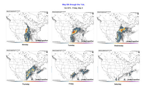
SupporterNext week could be the time to travel. May 6-10.
Weekdays are favored for safety. Fewer new chasers driving solo while data distracted.
GEFS and EPS, GFS ensembles and ECMWF ensembles, have a Rockies trough and southwest flow next week 6-10 day period. Said models keep a decent pattern in the 11-15 day but the AI artificial intelligence versions do not. In fact the AI goes total opposite ridge West trough East for the 11-15 day. Weekly products also go down the tube by Day 15; so, the AI might be right if the pattern changes quicker right after Mother's Day. This week should have midweek action, but the decision point in time has passed. Therefore I have to favor the upcoming week.
Digging into deterministic and ensemble mid-range, it appears that a new trough will establish in the Rockies next week. Should eject 2-3 short waves. Hopefully it’s less progressive than this week; sits out there, and gives more chase days. SPC appears to favor the Euro over the fickle GFS in their Day 4-8 text. The weather pattern above and instability are mentioned. It’s probably going to be warm at 700 mb, but a few places should overcome each day.
Bottom Line: Odds are increasing that our chase vacation happens next week May 6-10.Jason N
EF4
I am looking at 23 - 1 Jun. not a ton to go off of just yet minus CFS, I haven't seen any SCP Chiclet charts yet. the earlier link posted by Adlyons doesn't work without a UN/PW.Bottom Line: Odds are increasing that our chase vacation happens next week May 6-10.Warren Faidley
SupporterToo much model spread ATM to even make a guess at what happens after this week's opportunities. What looked promising a few days ago is fading, like in past drought years when the models go into freak out mode. It's still way too early to make a guess, either way, but it would appear timing issues may be a problem next week. Going to be a day-by-day process, trying to make a decision not based on a one day event, but the longevity of activity over the next few weeks. I see zero prospects for chasing anywhere in western Texas, E. NM or E. Colorado in the near term, which is highly irregular for this time of year, except in the current drought mode. I feel the pain of farmers, ranchers and dent repair shops.Dan Robinson
EF5
I will say that the last few events have had that 2004-ish feel in the sense that many of the targets each day produced items of quality. Something we haven’t really seen in a long time. I know it’s early, but this season already feels/is different in a productive way, at least to me.Last edited:JamesCaruso
Staff memberI will say that the last few events have had that 2004-ish feel in the sense that many of the targets each day produced something of quality. Something we haven’t really seen in a long time. I know it’s early, but this season already feels/is different in a productive way, at least to me.
I hope you’re right Dan, because (without going back to my journals) I recall 2004 being a pretty good chase vacation, so it wouldn’t be a bad analog to hope for…JamesCaruso
Staff memberI refuse to worry about the chiclet chart. It shows today 4/30 and tomorrow 5/1 in the deepest blue. Yet there are TOR reports today and a 5% Day 2 convective outlook for tomorrow. Even Friday 4/26 and Saturday 4/27 - they hit the “X” threshold, but were still in the blue color family.Greg McLaughlin
EF5
Based on what I am seeing at this point, I believe 2024 has a chance to be a legendary year in the plains and Midwest. We have had 6 days straight of tornadoes in the plains with 3 of those days "overperforming" to what was projected. The GoM moisture has finally arrived. We are getting excellent EMLs overspreading the warm sector with sharp drylines. The trough ejections this spring have been excellent with negative-tilt ejecting waves and strong lee cyclones. Dan mentioned 2004. I agree and think this has a 2004 or 2010 vibe to it.
I do believe there will be a short stretch (maybe a week or so) during May where there pattern briefly becomes less than favorable for severe, but I would expect that things reload for the end of the month going into June. Buckle up folks, we have been long overdue for a more classic plains-style season and Ma Nature might actually be delivering this time.Brett Roberts
EF5
Don't have time for any detailed analyses or thoughts, but the pattern that started today and should last through sometime next week appears very impressive for early May. You could pick at flaws with any individual day or setup, but my thought looking at NWP guidance yesterday was that this looks more like a reasonably good late May or early June pattern, where virtually every day at least gives you a chance of mesoscale accidents, boundary interactions, etc. Today was a great example of that, with multiple impressive tornadoes in separate areas (albeit mainly after dark in OK). Overall, it's hard to ask for much better of a look for May 1-10, short of an historic sequence of multiple violent outbreaks like 2003.
As for the remainder of peak season from mid-May onward, there are some encouraging signs on the ensembles, but many recent years have illustrated the folly of projecting the vibes of early season activity (or lack thereof) forward. After the Springer event in 2020 and a fairly active April in 2022, there was lots of chatter about "this year is different" and such... and we know how those turned out. As I said earlier in this thread, I do lean toward optimism for this spring overall, though... and if we can dump several inches of rain on areas like NW OK and SW KS over the next week or so, that will move the needle a tick further in the optimistic direction.Cameron L.
EF0
The last 2 model runs for both the GFS and ECMWF have the trough ejection flattening out after May 6th and keeping the moisture out of the plains for a solid week after that, so it seems like there might be some down time mid-May. Won't cancel chasecation yet of course but hopes are diminishing, by the looks of how the trough ejection will play out (am happy to be proven wrong, though).Jason N
EF4
yeah, I am thinking that might be because its CFS I think? might as well be GFS with as much flip flopping as it seems to do, so I am inclined to agree with you.I refuse to worry about the chiclet chart. It shows today 4/30 and tomorrow 5/1 in the deepest blue. Yet there are TOR reports today and a 5% Day 2 convective outlook for tomorrow. Even Friday 4/26 and Saturday 4/27 - they hit the “X” threshold, but were still in the blue color family.Jason N
EF4
I just looked at the preliminary TOR count reports for 30APR and man, to take an anchorman phrase, "that escalated quickly" lol.Warren Faidley
SupporterThe models for next week derailed into a dynamite factory!


Monday looks like it will materialize too far east for me and will be followed by the doldrums.
The next logical ****possibility**** appears to be around the 9th+. I'll reset my launch date accordingly. The good news is that the NCEP Ensembles continue show some form of positive flow for the extended.Joey Prom
EF1
I was planning to go out either late next week, or the week after, but it looks like I will be needing to reset my plans for a week. Good thing I fly out last weekend. Had a career day on Friday the 26th, capturing 11 tornados.Jeff House
SupporterMonday still looks like it could be a day, but details are getting murky. At the surface and occlusion would cut off the best boundary intersection from the best kinematics aloft. Then a tear drop trough doesn't help matters. If those can resolve, Monday could still go off.
Of greater interest to me is a possible Midwest and Mid-South sequence Tuesday through Thursday. I'm not sure why the SPC mentions Louisiana! Looks more like the total eclipse path AR/MO/IL/IN etc. Upper jets punch through that region. LLJs respond into that region. Surface features are that region.
It's a lot closer to me than the Plains. Should be fewer data distracted solo new chasers east of the Mississippi River. What we give up on terrain we more than gain on driver safety.Warren Faidley
SupporterStill looking dismal after early next week according to the 12z 5-2-24 GFS and all the long range models. RH will be lacking no doubt throughout the Plains. Could flip-flop of course.Jason N
EF4
I got the distinct feeling looking at the runs today, that the 3rd/4th week of may might be like last year where your chase stays in west TX to Clovis. CFS is so vastly different than GFS at 384, almost makes going forward pointless, especially since CFS is significantly different from run to run itself from 384 to 500. I don't usually go past that, no point in it.Warren Faidley
SupporterI got the distinct feeling looking at the runs today, that the 3rd/4th week of may might be like last year where your chase stays in west TX to Clovis. CFS is so vastly different than GFS at 384, almost makes going forward pointless, especially since CFS is significantly different from run to run itself from 384 to 500. I don't usually go past that, no point in it.
Yes, the Clovis triangle where magic and fun can be had by all!
I'm still counting on the NCEP Ensembles, which still show favorable SW flow past the 16th. The RH is more of a seasonal thing, so my deployment plans are based 75% on the RH return. I've learned over the years, any kind of SW flow with 55+ dp's and you go there.
I did some very quick research last week about May / June tornadoes in E. NM and discovered the majority occur after May 13th.John Farley
SupporterIf SPC is even close, the next week would be an ideal time for a chase vacation. For anyone lucky enough to have been in the Abilene, TX area yesterday, you would not have to move much for today and tomorrow. Then an easy drive north Sunday for Monday's setup, which it is increasingly looking like you could follow east for a couple more days. I am not in a position to chase in this time frame, but for anyone who is, especially if you are already in west-central TX, this is looking like a pretty active period.JamesCaruso
Staff member^ Making it that much more likely it shuts down the following week when I get out there.
May 13 is the earliest I am able to get out there in many, many years - usually it’s not until May 20 or later - yet oddly and sadly it’s still not early enough. What an awful hobby.Warren Faidley
SupporterNext week looks good for chasing if you don't mind the real estate after Monday, which appears to be a big day. After Monday, the pursuit moves too far east for me, into the Mekong Delta Regions where some chasers are still missing after 20 years.


Towards the end of the week, RH recovery will determine the next chase period.

AndrewHamm
Enthusiast
Yes hopefully we get moisture return after Saturday/ Sunday next week. Kansas looks big time on Monday. Around Paris, Texas could be a target for Tuesday, Wednesday, Thursday, albeit maybe not quite the risk as the MS Valley, but much better terrain for chasing. Then hopefully a RH return by Monday or Tuesday (13th or 14th) although models don't really show thatJeff House
SupporterI see Illinois and Indiana days next week. Tuesday and Wednesday could be gems at about half the distance to the Plains for me.
Chaser partner and I are both jammed up Sunday, totally separate personal calendar items, so we can't travel for Monday. We are free the rest of the week though. Convenient.
Tuesday Wednesday and Thursday are all dependent on convection the prior night into morning. Hopefully it doesn't get rain-cooled into the Ohio River Valley which is dreadful terrain. SPC also gets the Mid-South which is threading the needle to stay in the Delta. Can we have a classic Midwest sequence instead? Keep the boundaries north of I-64.John Farley
SupporterThere is quite a bit of good chase terrain in Illinois, Indiana, and much of eastern Arkansas. Not everywhere, but the terrain is not good everywhere in OK, KS, or any other state. Storms farther east do tend to be somewhat lower-based and the skies sometimes hazy, but there are still good chases to be had in parts of IL, IN, and AR. So if you do not mind travelling to follow the setups each day, there could well be possibilities.Brett Roberts
EF5
Although the next few days continue to look solid for early May, as advertised, global ensembles currently suggest a more substantial mid-month break than one would ideally like to see. The ECMWF EPS shows deep eastern troughing dominating the pattern after Monday through the end of its cycle around 5/19, while the GEFS and CMCE at least show some zonal to WSW flow nudging into the Plains starting around 5/15, and less pronounced troughing on the eastern seaboard.
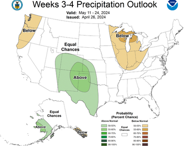
The ECMWF weeklies suggest we could be headed toward periods in the late season with a similar pattern to last year: a tendency for some eastern U.S. troughing, but shortwaves continue to sneak into the Plains. Last year from late May into June, that led to a ton of mesoscale setups with modest flow, and many of them yielded good results. As always, ET and wet soil conditions are helpful in these subtler setups, so areas that have received lots of storms the past several weeks may have an edge in such a regime. But, needless to say, even the large-scale pattern could still turn out quite different than any current NWP guidance depicts at the 2+ week range.Similar threads
- Replies
- 367
- Views
- 47K
- Replies
- 1
- Views
- 228
-
This site uses cookies to help personalise content, tailor your experience and to keep you logged in if you register.
By continuing to use this site, you are consenting to our use of cookies.


