2024-05-07 EVENT: IN/OH/MI/IL/KY

Joined
Mar 4, 2004
Messages
145
Location
Kalamazoo, Michigan
A region ahead of a secondary surface low forecast to be situated around Southern Lake Michigan by early Tuesday afternoon; along with primed mid/upper level support, inbound shortwave, vertical sheer, surface moisture in the mid/upper 60’s eludes to a potential regional severe weather/tornado event from the extreme southern tier of Lower Michigan [along and south of I-94] into Northern/Northeast Indiana and Northwest/Western Ohio for the mid/late afternoon and early evening hours. SPC SWODY2 has increased tornado probabilities for this zone of which bare monitoring.

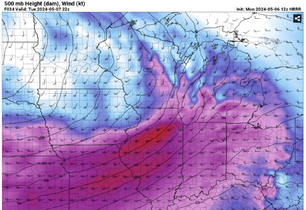
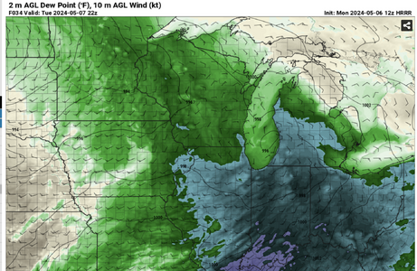
I would anticipate AZO to SBN could very well get into the warm sector dependent on where the secondary area of low pressure and warm front set up by early afternoon; yet based on multiple 12Z CAMs, the N IN/S MI/NW OH border towards FTW [Fort Wayne] trends more primed for supercell thunderstorm development with all hazards possible. Attached are the 500/Td/Surface Wind spread at 22z of the 12z HRRR, a theme also suggested in several other CAM runs.
 

Attachments

  • 22z 500 hrrr.png
    22z 500 hrrr.png
    1.9 MB · Views: 6
  • 22z Td hrrr.png
    22z Td hrrr.png
    2.1 MB · Views: 2
Last edited:
I've been keeping an eye on this for a few days now, as I am in Fort Wayne. Every logical part of my brain looks at that midday QLCS rolling through and wants to discount it, but after 3/14 (that I sat out thinking the atmosphere wouldn't recover), I can't in good conscience sleep on it a second time.

Even the NAM3km, which is somewhat notorious for favoring QLCS, is showing things favorable of at least semi-discrete convection and also showing solid recovery in the wake of the midday convection. Barring surface obs tomorrow showing no signs of recovery, I plan to be out tomorrow, and I don't think I will have to venture very far from home.
 
Backtracking to very distant comparisons, 5/7/2024 has a direct 5/13/1980 type signal [when a series of regional significant tornadoes from SWL MI/AZO to NW OH transpired] only a tad south towards the IN/MI border. Better surface temps and dewpoints along I-80/90. At this junction, LaGrange, Indiana would be the early/mid-afternoon focal point just ahead of the secondary surface low and regardless of how assorted CAM's convection suggested actually materializes. Will see how the WF augments Tuesday AM/Midday post early AM convection. There will likely be ample surface recovery post morning convection ahead of the secondary low as the mid/upper level dynamics support 4-6 p.m. CI. Interesting setup. Curious to what NWSFO IWX and GRR thinking will be. Monitoring from this point.
 
since I'm working today, I'm pretty limited in where to set up after work. luckily I'm located just off of US 31 in Westfield so I have the entire area between here and Kokomo to drive around relatively unimpeded by traffic. having briefly glanced at the NAM 3km, it looks like it showed some cells popping up around this area by ~21z. however with a small amount of showers that showed up about 30 minutes ago, along with the mid-day line of storms moving in around noon, I'm not entirely sure how that's going to affect convection in this area.
 
Still maintain the general forecast focus zone from prior post/s regarding the evolution of this afternoon in the wake of all pre-WF sub-severe convection. A potent mid/upper level punch with a very pronounced diffluent split over SWL MI by 22z [most all CAMs align] ahead of a secondary surface low, presently somewhere around the Quad Cities/Davenport [in IL], will gravitate towards Western Michigan by mid-afternoon. CI is trending towards overall discrete supercell mode along the MI/IN border, perhaps US-20 and points N/E, with more of a clustered mode towards AZO-Battle Creek on a "pick your CAM" suggested basis. There is a good indication that “Michiana” recovers into the low/mid 70’s with Td’s around 65-70 as the atmosphere recovers in the wake of the inbound initial storms over IL and destabilizes. This is the type of synoptic event in the Great Lakes that often produces strong tornadoes, also noted in the present SPC SWODY1. As this is a “backyard” regional day for me, I’ll likely be somewhere along or south of the IN/MI border, yet that zone will be fluid as the mesoscale environment evolves.
 
I'm concerned that enough moisture can get there in time (especially Michigan) and that the atmosphere will recover from any earlier convection. But the shear profiles in northern Indiana are outstanding. Further south CAPE will be better but the shear isn't as good. As always there is a question of whether there is enough capping and not too much lift for things to remain discrete. In the end it seems that my own analysis agrees with the SPC's tornado risk area from the 13Z outlook, and I think anywhere in the Indiana portion of that is a good target. I will watch from north of Indy and see what happens. Good luck to those of you out today.
 
Trends have a believable rapid transport of mid-60+ Td's and surface temperatures warming into the low/mid-70's all the way into the southern tier of Michigan. Present observed Td's already around 68 at Frankfort, Indiana NW of Indy and getting pulled northwest towards the encroaching low with rapid clearing already underway in Illinois. I expect forecasted [Td/T's] will be realized in Northern Indiana/ "Michiana" along and south of the I-94 corridor by 21-22z. A geospatial zone of backed SE winds anywhere between US 6 and US 20 in N. IN on north to the MI-IN-OH border definitely bares watch for any discrete supercell/s that materialize.
 
Making a data check stop at *home* of all places after the drive east from the Plains. A pretty ominous look on radar at the moment in eastern IL/western IN with numerous discrete storms, each already displaying broad midlevel mesocyclones. The environment improves into Indiana with more southerly surface winds. I can't make this current activity in time. I'm heading east on I-64 thinking a similar situation may evolve down here at sunset, with a solid sideswipe of a potent midlevel speed max/right entrance region.
 
Looking at obs, surface winds are already veering west of IN-15 (North of Marion) and IN-9 (South of Marion). Meanwhile, they're still backed east of those two highways. I'm currently sitting at home since I have a while yet before I need to make a decision on whether to target north or south from Fort Wayne. As expected, a new MD has come out calling for a downstream tornado watch to be issued prior to 22Z. Most of the I-69 corridor north of Grant Co IN is just east of the current watch that's up.

While it's tempting to go west for the ongoing storms, my preference is to wait for them to get further east where the surface winds are backed. So far, the HRRR and NAM3km seem to be handling the evolution of storm development fairly well, so I'm going to plan as if backed surface winds will remain in place along the I-69 corridor north of Grant County like they're both indicating. It appears the warm front has lifted well into lower Michigan, along the I-94 corridor, so I'm not as concerned about any storms in Northern Indiana jumping the front as I ordinarily would be.
 
Lots of very impressive radar signatures ATM. Just an observation, maybe others have noted this before, seems like a lower-rated, post high-risk day where some will say the day was underestimated. Not an accusation, just a question that has come up before.
 
Portage, MI apparently impacted directly. Updrafts here in southern IL/IN have so far been mushy. Waiting to see if the jet max/LLJ can get things going before sunset. Closing in on the new storm at Dale, IN now.
 
Back
Top