• A friendly and periodic reminder of the rules we use for fostering high SNR and quality conversation and interaction at Stormtrack: Forum rules

    P.S. - Nothing specific happened to prompt this message! No one is in trouble, there are no flame wars in effect, nor any inappropriate conversation ongoing. This is being posted sitewide as a casual refresher.

2024-04-27 REPORTS: KS,/OK,/TX

Began Saturday in Overland Park, Kansas with anticipation of a frustrating day to the south in north-central Oklahoma and/or southeast Kansas. Four areas had my attention, one the obvious boundary that was percolating towards Topeka; north-central Oklahoma for later day surface recovery; south-east Kansas around Yates Center for a continued evolution of morning supercell/s moving out of NC Oklahoma and the fourth far south towards Wichita Falls/Red River. Favored north-central Oklahoma and points south of the metro due to later day atmospheric recovery, assorted parameters and the pronounced upper/mid-level diffluent split over the region.

Sunshine revealed about an hour prior to departing the KCI area. The atmosphere beaconed “stay here", but regardless of being geographically closer to home and in a favorable environment, I proceeded south. Once south of Wichita, the lead HP supercell near Arkansas City was tornado-warned, with stabilized air behind that and ahead of the next convective cluster. Continued south until a steady increase in temperate and moisture was evident. By 3 p.m. a cycling supercell moving north/east from Binger towards Okarche was the obvious “a ha” moment, so I gravitated towards the obvious.

After a bit of a westward shuffle northwest of Edmond, headed north on OK 74 with only an occasional view of the updraft flank. Otherwise, pure surface gray haze prevailed. Eventually stopped on a quiet farm road east of Covington and west of Perry at 6 p.m., tripoded and watched the hazy mesocyclone and wall cloud pass by. No tornado observed at that point, although one had been reported earlier by KFOR-TV storm trackers per the radio simulcast I was listening to. After the masses for mesos rapidly streamed north on HW 77, I followed the storm north of Perry and the Cimarron turnpike as another wall cloud cycle passed on by.

Exhausted by that point and only running on four hours of “rest” after Friday’s tornado-spun energies, I called it a day and headed east towards Tulsa, eventually stopping in Joplin for the evening. As expected, another supercell revved up and went tornado warned as anticipated near Ponca City, yet by that point with dusk inbound; dinner, a hotel and solid rest were needed.

That wraps up a three-day adventure in the Central Plains/Midwest with a wide variety of atmospheric scenery, multiple tornadoes and people conversed with along the way. Until the next cycle, that’s all folks!
 

Attachments

  • IMG_3622.jpg
    IMG_3622.jpg
    189.8 KB · Views: 5
I ended up on the same storm as Blake. This picture from near Hinton kind of captures the nature of the day:

vidcap2-421724.jpg

I started out from Dodge City, originally hoping to catch something along the dryline in western KS. But with that looking increasingly unlikely, I turned my attention to the already-large cluster of storms in western OK in the morning. For a while radar showed more of a northward than eastward component to their motion, and some CAMs showed them getting as far north as Greensburg, so I had some hope of catching something on the western edge of the cluster in southern KS. But it soon became evident that was not happening either, so I headed into OK. Crossed through the messy line of storms near Seiling to get ahead of the line, which proved to be more difficult than expected as new storms kept going up ahead of the line. Once I was ahead of it, I saw on radar that there was a much more isolated storm somewhere near Alfalfa and decided I could catch it somewhere near Binger. Before I could get there, a new storm went up ahead of it and I figured that would be the better option. But since it could cut off my route to Binger, I circled around and approached it from the east. Difficult navigation in this area due to a closure of US 281 north of I-40 and limited places to cross the Canadian River.

Once I made it to Binger I joined the chaser mob and followed the storm up to I-40. The picture above captures both the appearance of the storm and the major backup of chaser traffic. I usually avoid chasing within 50 miles of OKC for this reason, but today if I wanted to see a storm from where I was, this seemed like where I had to go. A major factor in the traffic was a 4-way stop at the center of Hinton. This was very similar to what I experienced in Red Bud, IL after the total eclipse, but it is a lot more frustrating when you are trying to keep up with a storm. I eventually pursued it north and east as far as Perry, but was behind most of the time as I never fully recovered from the traffic jam. I never saw any definitive tornado despite the storm getting a total of five tornado warnings, and most of the time the meso was at least somewhat wrapped up in rain. Edit-I did just see that tornado damage was reported between Geary and Calumet. In hindsight, I did see a front-lit lowering in that area as I was blasting east on I-40 to regain position, but I could not see down to ground level due to hills and trees. So, I don't know.

There was some decent rotation in spots around Binger and Hinton, some in the main meso but also some in the base of the flanking line just southwest of the main meso. Gave up the chase at Pery and returned to El Reno to get a room for the night before heading back west.

After dark the storms really got going south and east of OKC, including southeastern parts of the metro. Sorry to hear of the damage, injuries, and fatalities in some of those areas.
 
Last edited:
I saw a tornado, but the lightning catches were my best of this day. I started in Ottawa, Kansas, indecisive about the day's target. The better parameters were going to be along and ahead of the dryline in central Oklahoma. Satellite/radar showed that area getting plenty of sun, with the ongoing storms to the northwest of it not looking to sweep through and wipe it out early. The problem with central Oklahoma during a big tornado event on a Saturday is that the number of chasers and locals on the roads would potentially be high, especially if there were only one or two storms. So, I decided to target the northern end of the risk area along the Kansas border. Models were also insistent on a large squall line with trailing stratiform precip in Oklahoma City and/or Tulsa, so I wanted to get to either of those locations in time to capture the upward lightning show.

Supercells were already evolving from the morning storms as they crossed I-35. I intercepted the best-looking one at Dexter, KS as a huge RFD surge produced a tornado as it curled back into the meso. The storm was also producing a barrage of positive CGs, many far ahead of it into clear air - a few that were close.

Unfortunately, the storm was HP (high-precipitation) and this circulation was completely rain-wrapped. I parked on Highway 166 for a while, hoping that the rain would clear out on the back side of the meso to reveal the tornado - but this didn't happen. I waited for two new storms to come up from the south between there and Cedar Vale, but they were cold and outflow dominant. The outflow was also consolidating and surging southward, which would undercut additional storms coming up from the southwest. I decided I needed to get south of this, so I headed south on Highway 15 into Oklahoma.

The south end of the outflow was visible intersecting a new supercell updraft west of Foraker. I turned east to stay just ahead of this (thankfully the road was paved). The forward flank tail cloud was racing into a new mesocyclone and wall cloud to my south. Intermittent funnels appeared under the wall cloud. Multiple areas of rapid spin developed on this boundary, including right ahead of me and nearly overhead. This was an amazing sight overhead! As the meso moved northeast, it produced several weak tornadoes (or just the same tornado re-intensifying) under the center of the main circulation. These manifested as debris clouds and areas of spray kicked up from the wet fields in the center of rotating rain curtains. I did not get any good video of these, and they were not very visually spectacular to begin with.

april2724l.jpg


The east-west road past Foraker eventually dead-ended into a muddy north-south road, so I had to let the storm go.
I drove back south to Ponca City to get in front of the long-lived supercell that had produced tornadoes down near I-40 a couple of hours earlier. It had weakened considerably, but I felt it might eventually recover as the low-level jet intensified. But, I had some time before it arrived and that would occur, so I was able to stop for a quick dinner/coffee. As the storm moved into town, it began producing a flurry of tall negative cloud-to-ground lightning strikes way out ahead into clear air. I was able to catch 2 of them on the high speed camera at 6,002fps, one which is now my best high-speed lightning catch:

The lightning barrage here signaled the expected intensification of both this storm and a new supercell to the south. Despite this, the original storm looked cold, and motion was weak. I decided to drop down to the new storm, which was looking much better on radar. It too, was cold-looking with no motion observed in the updraft or developing mesocyclone. After the second storm moved through Ponca City, there were no good roads to stay with it. The expected squall line evolution seemed to be taking place to the south with electrified stratiform developing and moving toward Oklahoma City, so I decided to abandon the Ponca City storm and head south into OKC for upward lightning.

Although I had a hard time battling wind-blown rain in Oklahoma City, the upward lightning show was spectacular. I captured many good stills, 4K video and high speed 1,500fps shots. There were several slow positive upward flashes. I lost count of how many there were, but there were well past 20. The high-speed video takes a long time to process, so it will have to wait until after I get home. Here are a few of the better stills:

april2724g.jpg


april2724c.jpg


april2724d.jpg


april2724e.jpg


This downward positive CG connected to one of the towers:

april2724h.jpg


The stratiform lightning mostly moved off to the east by 2AM, so I packed up and stopped for the night in the city.
 
Last edited:
I started the day bright and early in Altus, OK, leaving around 730am headed for Sayre, OK to target the morning convection. After goofing around along the I-40 corridor for awhile, even going as far west as close to Shamrock, TX, I declined to follow the now line of storms farther north and instead headed back south to Mangum, OK to start thinking about my afternoon play. For my longer chases, I like to plot my chase route after the fact, so here is my morning route.

Morning Route.png

While enjoying my incorrect (though still yummy) cheeseburger from the local Sonic, I noticed a discrete cell on radar down between Paducah and Quanah, TX. I drifted south to Duke, OK, and the cell was still discrete, though not especially impressive looking on radar. The simplest decision here would have been to head south from Duke to Eldorado, OK, but being local to this area, I knew of a road closure along OK-6 that would prevent an escape back towards the east if the storm decided to do something. So instead I went east along US-62 and the long way around to the small town of Olustee, OK to see what I could see. Which was still nothing. So I went back to the US-62/OK-6 junction and sat watching and waiting. It was here that I first encountered some chaser convergence, though it wasn't a hindrance. I even came across 1 of 2 DOWs and associated vehicles that I would see that day. The storm at this point looked visually like it was trying to get organized, but was still struggling. I went north through Altus, stopping near the airport to get the first interesting photo I have of the day. It isn't of anything specific really, just thought it was neat.

20240427_140446.jpg

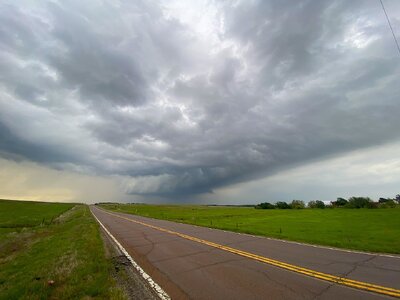
At this point, I again hung around debating what to do, but the radar presentation of this storm was starting to look better, so I decided to commit to this cell and catch back up. I headed north along US-283 to Blair, OK, and then east on OK-19 to Roosevelt. This started an afternoon of zig zagging in a general NE direction playing catch up. I followed US-183 north from Roosevelt to the junction with OK-9, and then east to Gotebo, where I stopped again. The cell I was on was looking ragged and a new cell had formed ahead of it near Carnegie. So I continued east to Carnegie, north on OK-58 to near Eakly, east on OK-152 to Binger, and then north again on US-281. This whole time I was just south or SW of the hook, but still behind enough not to be able to see much of anything. I was just south of Hinton when I got the best view of the storm that I would get. It was also here that I saw my 2nd DOW of the day. As a side note, I've never seen the DOWs in the wild on a chase before, so my nerdy side thought it was pretty cool to see them out there doing their thing. Here are some screen grabs of this sequence from my GoPro. Please excuse the bug splats, turns out the off brand washer fluid with "bug remover" doesn't quite live up to its name.

GH010002a.jpg
GH010002b.jpg
GH010002c.jpg

Just like John, I ended up in the chaser conga line through Hinton. By the time I got through the 4-way stop in town, the storm's circulation had moved well north of I-40 and it was unlikely that I could safely catch up again and get out ahead of it. Here is my view from the traffic, and if you look in the top right of the photo you'll see the storm getting from me.

20240427_162829.jpg

Before leaving Hinton, I decided to stop for gas and make a decision on what to do next. There was a pair of discrete, tornado warned cells down near the Red River moving NE, so I left Hinton, hit I-40 to El Reno, and then south on US-81 to Chickasha. I was hoping to intercept the more northern of the 2 cells somewhere between Chickasha and Anadarko, but by the time I got to Chickasha, the storm had all but dissipated. I got on I-44 heading south and briefly toyed with the idea of racing the big HP cell that was moving through Burkburnett, TX, but by the time I got to Lawton, the precipitation core of the cell was already impacting I-44 and there wasn't a safe way of pushing south for a view. I instead got on US-62 west, and back home to Altus. And per usual for most of my reports, I like to add one last photo from the trip home. This time I passed underneath some mammatus about 15 minutes east of Altus.

20240427_190543.jpg

Over all I was on the road for about 12 hours, and 528 miles according to my trip odometer. Here is the second half of my chase route from my stop in Mangum through to home.

Afternoon Route.png

As a post mortem I want to highlight the pros and cons of how I conducted this chase. The pros include:
- Making a plan and sticking with it. This was an issue for me in previous seasons that I think I may have finally gotten past.
- Choosing a storm and committing to it. Again, in seasons past when there were multiple storms to choose from, I had a bad habit of quickly giving up on one to chase another that looked marginally better at that moment. This usually came back to bite me. So the fact I stayed one on cell and gave it a chance in an environment that I knew should be good for it, and only swapping to its immediate neighbor when it was clear it was being choked off, is an improvement for me.
- Between this day and my 24 March chase (where I caught my first supercellular tornado), I'm realizing that I may finally be comfortable navigating these storms by visuals alone. In the past, I have been overly reliant on radar, even when I have a visual on the storm (I know, I know). The problem was that I was never confident in my ability to pick out storm structure, know what I was looking at, and then act or react accordingly. I think I finally have enough chases under my belt, and enough hours reading through Storm Track threads and watching Skip Talbot safety videos, to trust myself once I have that visual.

As for the cons:
- I think I could have done without my morning escapades along I-40, and instead probably should have focused on positioning further east, which leads to my second con.
- I have a nasty habit of ending up literally anywhere but in good position on a storm. So instead of stopping to take photos or video, backing up as the storm approaches and then repeat, I spend most of my chase frantically playing catch up trying to get into position. Since I'm in the Air Force, its really hard to get off on short notice for chases, so most of my chases are relatively close to home in the SW corner of Oklahoma delineated by the I-35 and I-40 corridors, and adjacent parts of north Texas and the Panhandle. This is because I can leave work an hour or so early and get to the action before sunset. The issue is that I can rarely be picky about my starting position in relation to where storms initiate, and Altus is almost always SW or directly north of initiation, with the exception of Panhandle chases. For future chases like yesterday, where I had literally all day to plan and the luxury of being picky, I really need to make sure I am staying ahead of the convection rather than approaching from behind it.

My overall thoughts on this chase have changed quite a bit from when I got home last night. Fresh off of the frustration of seeing nothing and seemingly being hampered at every step by events outside of my control (chaser convergence) had me saying the chase sucked, was a waste of time, money, and gas, along with a few other choice words that aren't likely appropriate for this sort of a report. When I woke up today and started compiling my route and photos and such to write this report, I realized that even though it didn't go the way I wanted, I had a blast. I always have fun when I chase, even on the extremely long days where I come up empty handed. To connect with Mother Nature, some people hike, others camp, I storm chase. As much as it hurts to come up empty handed so often, I'm going to keep stubbornly heading out into the middle of nowhere, hours from home, seeking the chance to experience first hand the power of Nature. See y'all on the next one!
 
Last edited:
Saturday’s target region was based on a comment in the SPC 1630Z Day 1 Convective Outlook: “Only weak upper forcing through the afternoon will result in chaotic development of discrete supercells in a very strongly sheared and very unstable environment.”

Hour by hour the early HRRR runs seemed to reflect this, so I decided on the area just W of I-35, along an axis Marshall-Covington-Garber. This area was far enough north I would be able to move south to intercept rather than drive north to chase. The hope was that the more discrete supercells would form in this area, or points E, and I would get a chance to intercept them before they got N of US-412 and E of I-35—an area I try to avoid.

To avoid tolls on US-412, we opted for OK-51, and arrived in Stillwater about 2:15PM, at which time there were two potential targets: messy-looking complexes that had me wondering if I shouldn’t have targeted the Enid-Garber-Ponca City area (further north) instead:

20240427_1415Z_KTLX-REF1.jpg

I decided to intercept the northernmost cell near Perry, thinking that, although the southernmost cell looked better-organized, I would have time to get back into position to intercept the southern cell if necessary. This was a mistake—the southernmost cell had unimpeded access to the southerly flow of warm, moist air. I knew this, but for some reason just spaced it out--a form of chess blindness, I suppose.

Predictably, the northern cell did not really get even marginally-organized before it moved N of US-412, and following it would have probably cost me the opportunity to see the Stillwater tornado. Luckily a train blocked US-64 in Perry and forced me to change targets to the “right cell”.

Having a hard time judging the cell’s trajectory, I decided to reposition E with the intent to move S--approaching the cell from the east. However, by 3:06 PM it was clear we would have to approach it from the north along US-177, passing through the cell's front flank. By this time it actually had an identifiable front flank, and was looking more and more like a “classic”supercell. (Certainly compared to a half an hour earlier, anyway.)

20240427_1506CDT_KTLX_VR1.jpg

By 3:15PM, traveling S on N. Perkins Rd (parallel to and just east of US-177) we were close to emerging into the inflow notch and began looking for a good view. There is a line of trees along much of N. Perkins Rd in this stretch, but it didn’t take too long to get a clear view of the wall cloud.

Here is a panoramic shot of the wall cloud from our first stop. (3:15PM CDT, looking WSW. Panorama stitched from photographs taken with Nikon D-60 using the program Hugin.)

DSC_0080 - DSC_0083.jpg

To compare the photographic record to the radar data, this is the KTLX radar for the time approximate to when the photographs were taken. Our location is indicated by the blue dot.

20240427_1516CDT_KTLX-VR1.jpg

This spot had a great view, and I will remember it in the future, but the wall cloud very quickly began to move out of sight.

DSC_0085_cropped.jpg

Proceeding N again, we had to panic stop at a clearing in the trees as a funnel cloud formed and began to drop to the ground. The time now is 3:26 PM CDT.

20240427_Tornado.jpg

Now comes the second mistake—if I had run a few tens of yards south to get a better angle, I would have seen the fully-developed tornado documented elsewhere in the reports for 4/27/2024. Instead, I decided to proceed north on N. Perkins Road and by the time we got to the next clearing it was all over. Bad luck, really, because either decision may have brought me to a bad end and there was no way to predict the tornado would only last a couple of minutes. So: I guess not so much of a mistake as bad luck.

We followed the cell north of US-412, turning E on OK-15 to see if zig-zagging E-->N-->E would pay off, but gave up the chase when it was clear the cell had acquired an 8-mile head start—with a storm speed of about 40-45 mph, we were not going to catch this cell without serious speeding.

That’s really the end of the photographic record—we proceeded N on US-177 trying to decide how and when to intercept the messy line of cells approaching the Tonkawa-Ponca City area from the SW.

On US-77, south of Tonkawa, low-lying farmland was flooding and the road was barely passable: it was clear we would not be able to use it later to return home. It was getting dark, heavy rain was moving in, and Tonkawa residential streets were flooding as drainage swales overfilled their banks and made it impossible to tell where the roads ended and the swales began, so we packed it in for the night.

--------------------------
As a final note--I was surprised to see very few chasers on this cell. Nothing near the chaser convergence reported by others elsewhere. Considering the proximity to Oklahoma City and Stillwater, that was surprising.

EDIT: Correction to my report--the picture of the developing tornado was taken from US-177 about .3 mi south of Glencoe Rd. Continuing my post-analysis (which would be annoying to give here in full), I found the error while trying to reconcile my notes with picture location data. It makes more sense, now. But alas! I missed the window to edit the post and make the corrections in situ.
 
Last edited by a moderator:
Mechanical and technical failures kept me in Western Iowa and away from targets further south. (They were windshield wiper assembly failure and gps failure on phone)

Had a few tor warned storms make a meager attempt at rotating but low levels did not seem conducive.

Until next time...
 
As a final note--I was surprised to see very few chasers on this cell. Nothing near the chaser convergence reported by others elsewhere. Considering the proximity to Oklahoma City and Stillwater, that was surprising.
I think that was due to the storms up north being more of an MCS type with them going through the same areas as others before them. In SW OK there was an isolated cell that looked much better so a lot of people headed that way earlier looking for OKC ish intercepts. Stillwater happened as it was out away from those MCS type storms in untouched air. I stayed up north a bit longer to watch and see if an isolated cell happened and it luckily did. Another reason too is that it ramped up very quickly so if chasers were not fairly close they were late. It surprised me the tornado did not last longer with that quick ramp up.
 
After looking at the damage surveys and other info, I think it is very likely that I did catch some glimpses of the Geary/Calumet tornado through the trees while I was blasting east on I-40. Not totally sure, but likely. I saw that the NWS did confirm another brief, weak tornado southwest of Hinton, but despite being in what should have been perfect position, I did not see that - too much rain in the way from my viewpoint. I have now finished my full report and have posted it at:

 
Back
Top