• While Stormtrack has discontinued its hosting of SpotterNetwork support on the forums, keep in mind that support for SpotterNetwork issues is available by emailing [email protected].

What makes a tornado wide and or violent?

Joined
Sep 29, 2025
Messages
12
What key ingredients like CAPE or SRH or LCL, etc make large weak wedges and powerful drill bits, and everything in between? I’m working on a video game and wanted to have tornadoes form and look based on certain conditions and not just a random value
 
There are multiple combinations of shear/instability that can result in violent tornadoes. More of one can compensate for less of the other. You'll probably find this post about the 2011 Super Outbreak by Jon Davies interesting, he has a good scatter diagram on there showing F2-F5 tornadoes in the context of 0-2km SRH and MLCAPE:


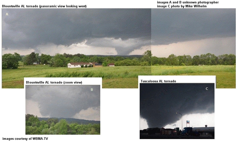
Funnel width is a function of the pressure drop vs relative humidity of the air in the tornado. The stronger the tornado and/or the higher the ambient RH will result in wider funnels. Lower LCLs (cloud bases) can make smaller tornadoes appear more "wedge-y".
Ok, but what about the width of thr tornado’s circulation, what determines the width of the storm’s circulation of tornadic winds?
 
Ok, but what about the width of thr tornado’s circulation, what determines the width of the storm’s circulation of tornadic winds?
The visible condensation tornado funnel is only a part of the total rotation that is going on within the parent Cb and the condensation funnel does not necessarily correspond with the overall field of air motion in the near environment of the funnel, especially near the ground where asymmetries such as inflow "jets" and suction vortex spin-ups can occur. Much of the "circulation" processes that result in the visible tornado are actually occurring aloft, above the cloudbase (LCL) or even sub-cloudbase wall cloud. To get an idea of what "diameter" the rotation is occurring aloft above the tornado, real-time mobile Doppler radar observation and data-sampling, together with specialized computer modelling, is required. However, to determine the wind-motion field near the tornado itself, terrestrial photogrammetry analysis of suitable video imagery is by far the best way to answer the question about "the width of the tornadic winds." A Google search of either "mobile Doppler-radar or tornado-photogrammetry case studies" will yield many answers to your question.
 
I've always found calling a tornado "violent" kind of funny. That would mean a tornado acts with malice or has intent to harm, but really a tornado is just doing what it does whether we're here or not. I believe using the term "destructive" is a more apt term. Some are more destructive than others. "Violent" is more suitable to gain a few clicks and eyeballs at the end of the day.
 
The visible condensation tornado funnel is only a part of the total rotation that is going on within the parent Cb and the condensation funnel does not necessarily correspond with the overall field of air motion in the near environment of the funnel, especially near the ground where asymmetries such as inflow "jets" and suction vortex spin-ups can occur. Much of the "circulation" processes that result in the visible tornado are actually occurring aloft, above the cloudbase (LCL) or even sub-cloudbase wall cloud. To get an idea of what "diameter" the rotation is occurring aloft above the tornado, real-time mobile Doppler radar observation and data-sampling, together with specialized computer modelling, is required. However, to determine the wind-motion field near the tornado itself, terrestrial photogrammetry analysis of suitable video imagery is by far the best way to answer the question about "the width of the tornadic winds." A Google search of either "mobile Doppler-radar or tornado-photogrammetry case studies" will yield many answers to your question.
I wasn’t talking about the condensation funnel, I was talking about what influences the tornado width of circulation, not funnel size. With the intensity of the storm influenced by thing like Storm Relative Helicity, I wanted to know what counterpart it plays a role in the tornado’s width of tornadic winds (winds exceeding 65mph)
 
I wanted to know what counterpart it plays a role in the tornado’s width of tornadic winds
I guess I don't really understand what you're looking for. I don't understand "what counterpart it [SRH] plays a role in the tornado's width of tornadic winds" even means!

As others in earlier replies have stated, there are multiple (not just one) factors (dynamic, thermodynamic, micro-physical) that play a role in producing a tornado or a tornadic thunderstorm, for that matter. These factors influence the cumulonimbus (Cb) on various time and space scales, which if they come together in just the right way, will cause the Cb updraft(s) to rotate. The term "circulation" is meaningless within the meso-scale (i.e., thunderstorm-size space scale) and generally applies to much larger space scales (i.e., synoptic, hemispheric space-scales). The various parameters (SRH, CAPE) that you have made reference to are merely mathematical or formulaic constructs on a logarithmic thermodynamic diagram and, by themselves, have little relevance to the specific makeup of the Cb (i.e., "width of the tornadic winds," whatever that means), but rather capture a snapshot of the atmospheric conditions in which Cb(s), possibly becoming severe or capable of producing tornadoes, may form over a given area of landmass during an imminent time period (often used by the Storm Prediction Center in Norman, OK, to construct tornado- and severe-storm watch "boxes" that are conveyed to the public).

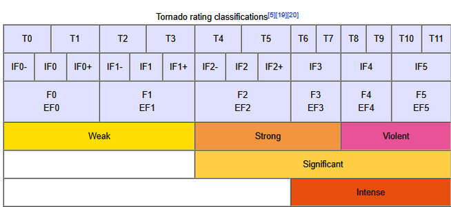
It seems you are "mixing apples and oranges" here, on both time and, especially, space scales. And, by the way, the Fujita EF0-5 Scale is also a similar tool to classify tornado intensity by observation of structural damage. Not all the structural damage in a given damage path is done by one tornado; there may be multiple vortices, satellite vortices, or straight-line inflow/rear-flank downdraft winds which can also cause such damages. All of these factors will have some influence on the "width of the tornadic winds" associated with a tornadic thunderstorm.

So, for all the reasons stated above, your question seems to make little practical sense, and thus may have no logical or meaningful answer.
Oh, but still, how does a tornado produce a large damage swath, and how it’s recognized as tornado damage and not straight line wind damage? especially for large tornadoes like the 2013 El Reno storm
 
how does a tornado produce a large damage swath, and how it’s recognized as tornado damage and not straight line wind damage?
The second part of your question is easy to answer. After a major tornado event where there has been any loss of human life, the National Weather Service routinely sends a team of meteorologists to walk all or parts of the damage path. If the fallen debris shows any sign of curvature in the path (i.e., debris from a single house structure that appears to have been scattered in an arcing trajectory), they would suspect it was a tornado (or funnel cloud) that passed over or near the structure. They might organize an aerial flyover to confirm and photograph the presence of "cycloidal swaths" at or near the location of the house and nearby crop fields. If the debris falls in a straight line from, say southwest to northeast, it still could be a small or weaker tornado rather than a straight-line microburst, so some additional investigation, corroborating radar and visual reports from the public/storm chasers with the damage-survey field data, will usually determine the correct answer.

As for the first part of your question, as already mentioned, there may not be any one answer, as each tornado event is different in terms of the vertical-atmospheric set-up and where those conducive conditions happen to come together. There also may be some physical interaction (such as surface friction, or "wind drag") between the terrain and the atmosphere overlying it. A rough, uneven, hilly, or urban landscape with lots of structures or tall buildings could affect the rotational winds on or near the ground resulting in unusual or asymmetric wind flows that appear to broaden the overall width of the damage swath. Generally, however, structural failure usually begins to occur toward the lower end of the Enhanced Fujita (EF0-5) Scale, depending upon how good (and how old) the construction and building materials of a structure are. These lofted solid debris elements are often centrifuged (or rotate along or outward) from the wall of the condensation funnel, resulting in a path width that could be wider than the funnel diameter itself. Fortunately, there are very qualified meteorologists, as well as structural civil engineers, who are skilled at figuring out how various piles of mangled debris came to be, and where they originated; their reports also fill in crucial questions as to how large the damage swath actually is.
 
I've always found calling a tornado "violent" kind of funny. That would mean a tornado acts with malice or has intent to harm, but really a tornado is just doing what it does whether we're here or not. I believe using the term "destructive" is a more apt term. Some are more destructive than others. "Violent" is more suitable to gain a few clicks and eyeballs at the end of the day.
Screenshot 2025-11-25 193754.png

Generally, when we say, "violent tornado," we mean one confirmed by damage survey to have been, or suspected based on some combination of visual appearance, environmental conditions and radar signature to be capable of EF4-EF5 damage.
 
This thread reminds me something I have always wondered.

Why are so many tornadoes funnel-shaped? Is it b/c as you go from the cloud base to the ground, the environmental atmospheric pressure is higher by default? Or does it have to do w/ friction or some other boundary layer factor?
 
Why are so many tornadoes funnel-shaped? Is it b/c as you go from the cloud base to the ground, the environmental atmospheric pressure is higher by default? Or does it have to do w/ friction or some other boundary layer factor?
I asked Google AI that very question. Here are the responses (short-form and longer-form):

Short Answer:
A tornado is funnel-shaped because its rapidly rotating column of air has a very low-pressure core, which causes water vapor to condense into a visible cloud of droplets (the condensation funnel). The pressure is lowest at the center of the vortex, and this extreme pressure drop is what gives the condensation funnel its characteristic tapered, funnel shape, says Britannica.

  • Low pressure: The high-speed rotation creates a vortex with a column of extremely low pressure in its center.
  • Adiabatic cooling: As the air rises in the core of the vortex, it expands and cools rapidly (adiabatic cooling), a process that can cause water vapor to condense into tiny water droplets.
  • Condensation cloud: This condensation creates a visible funnel cloud, which is made of water droplets. The shape is conical because the air is rising fastest and is coldest at the very center of the vortex, allowing condensation to occur lower down compared to the air spiraling just outside the core, notes Britannica.
  • Dust and debris: The visible funnel is often enhanced by dust and debris sucked up from the ground, especially in very dry conditions where there may be no condensation funnel at all, says Britannica.

Longer Answer:
The funnel shape of a tornado is primarily caused by two factors: a significant drop in air pressure within the vortex, and the effect of this pressure drop on the condensation of water vapor.

The Role of Low Pressure and Condensation
Inside the rapidly spinning column of a tornado, the air pressure is substantially lower than the surrounding atmosphere. This intense low pressure causes the air within the core to expand and cool rapidly (adiabatic cooling).

  • Condensation: If the air contains enough moisture and cools to its dew point, the water vapor condenses into visible cloud droplets. This process is similar to how fighter jets flying at high speeds can create a vapor cone during high-G maneuvers.
  • The Funnel Shape: The pressure is lowest precisely along the central axis of the vortex and increases moving outward from the center and upward from the ground. As a result, the air reaches its dew point closer to the ground near the center than it does further out, giving rise to the characteristic inverted-cone or funnel shape of the visible cloud.
Other Contributing Factors

  • Moisture Content: The appearance of the funnel is heavily dependent on the moisture content of the air. In very dry conditions, the visible condensation funnel may not extend all the way to the ground, or may not be visible at all, even if a powerful vortex of wind (a true tornado) is present. In such cases, the only visual evidence of a tornado at the surface might be a cloud of swirling dust and debris.
  • Intensity: Generally, more intense tornadoes with very low core pressure tend to have larger, more developed condensation funnels.
  • Airflow Dynamics: The tornado's parent thunderstorm (often a supercell) features strong, rotating updrafts and downdrafts (specifically the rear flank downdraft, or RFD) that help concentrate the rotation and pull the vortex down toward the ground. The interaction of these airflows creates the dynamic structure that results in the funnel shape. The shape can change markedly during a tornado's lifespan, appearing as narrow ropes, wide wedges, or stovepipes, depending on factors like wind intensity and atmospheric conditions.
The visible funnel is essentially an outline of the innermost core of the rotating winds, not the entire circulation, which can be much wider.
 
Reminder that AI* is a probabilistic model of which words appear together from its training dataset. It's basically a very sophisticated auto-complete. That means that it's very good at producing text that looks real, but there's also nothing about it that inherently makes it produce accurate answers. I strongly recommend not taking any AI output as fact without verifying it with a reliable source.
A big part of the reason I point this out is that I'm constantly running into examples of people getting incorrect information from AI and not realizing it until later.

*(I'm referring specifically to Large Language Models here, which is what "AI" has referred to recent years. The term has meant other things at other times.)
 
A big part of the reason I point this out is that I'm constantly running into examples of people getting incorrect information from AI and not realizing it until later.
I strongly recommend not taking any AI output as fact without verifying it with a reliable source.

Yes, Luke, good discussion points! You are absolutely correct about both of these statements, as a general rule. However, in this specific instance (for the question asked), I do not see any part of the answer from a meteorological perspective (I have graduate-level college education in meteorology) that looks obviously or glaringly incorrect or debatable. I admit, however, that I know nothing about "high-speed fighter jets that can create a vapor cone during high-G maneuvers," so I'll take a pass on that one! But, I do like the fact that the AI response cites Britannica (one of the oldest and most comprehensive encyclopedic information sources in the world which is extremely-well vetted for factuality) as a follow-up reference for further reading.
 
Back
Top