• A friendly and periodic reminder of the rules we use for fostering high SNR and quality conversation and interaction at Stormtrack: Forum rules

    P.S. - Nothing specific happened to prompt this message! No one is in trouble, there are no flame wars in effect, nor any inappropriate conversation ongoing. This is being posted sitewide as a casual refresher.

2015-05-27 REPORTS: TX, KS

I left work in Amarillo a little before 2, but didnt head NE from Amarillo till a little after 2. Drove up US 60 while towers went up everywhere. After Pampa I got a view of the Canadian cell. Very stout tower with a sizeable overshooting top. I was able to catch the storm before it did too much. Tried staying south of Canadian but was too hard to see the storm. Eventually crossed the river with everyone else. I didnt hang around too long as the storm drifted south some. I dropped back to the river a took a very tree filled road to the east that no one else was one. I could see the rotation had ramped up, but could not see the tornado. I was standing on my car near a place labeled "Anvil Park" (in Streets and Trips), when Brandon Sullivan pulled up and yelled "huge tornado" and drove away quickly. I followed him up to a ranch off the highway where we finally got a view. Had that cycle after that one produced we would have had great seats there. Saw a few more tornadoes near Canadian before it fell apart.

I quickly bolted SW (also the way home for me) towards the storms south of Claude. There was a major wreck on I-40 that had traffic jammed up and made me loop around the long way. Storm south of Claude really ramped up then so I tried to sneak up behind it through the canyon on Highway 207. Unfortunately the highway was closed due to rock slides on the south rim. I sat there in the canyon for a bit hoping they might open the road, but the storm started to move north back into the canyon. I had lightning striking all around me down in the canyon. Loudest thunder ever with those bolts coming down in the canyon. Also got some golfball size hail sitting down there. After I made it out of the canyon, I stopped for some lightning over a filled playa lake (last photo).

Will try to get around to some video at some point, but the lightning in the canyon might be the most entertaining stuff I got.

1e5442b620bfe5a3879681817e34af26.jpg

b9f76ac55d908f97b4c226b0cc2746e3.jpg

3c09a935d4cfb145b2d59ce1b6ac67ed.jpg

2c96be37b30df771a1f1c5ad84c42851.jpg
 
Never chased a storm that basically didn't move for a couple hours producing several tornadoes. We saw 4 separate tornadoes from 4 different wall clouds, including the big one north of town. I didn't spend a lot of time shooting pics as much as I did video, so here's the only pics I got.

Big tornado north of Canadian.
IMG_9859-X2.jpg

IMG_9864-X2.jpg


Tornado #2 west of Canadian.
IMG_9870-X2.jpg
 
Driving south out of Hays (western Kansas) towards the town of Ness, we targeted the strongest supercell in the area which began developing at around 3:30 PM just north of Dighton. We arrived on the storm just as it prepared to produce. The storm was nearly stationary at this point, on an almost unnoticeable eastward track.


The storm intensified very quickly and the tornado warned base began to assume a southeastward track which we didn't expect. While we were fairly certain that there was larger circulation or tornado wrapped well within the rain bands next to the inflow notch, an anticyclonic funnel dropped on the southeast corner of the mesocyclone for around two minutes. It never fully condensed, but was interesting and photogenic nonetheless.


We ended up directly in the path of this storm during its most intense period of tornadic activity, luckily 20 or 30 minutes ahead of it. We had been very unconcerned about the storms motion because it had been nearly stationary though it's early development, but took off southeast as it intensified, which followed our planned escape route. This storm has taught me to appreciate the unpredictability of these structures, and to keep careful watch of the radar under an HP base.

 
Saw pretty much all the tornadoes near Canadian, the first (big one) from U.S. 60 north of town, the rest from south of town.

It took me awhile to get out to the target area. I knew I wanted to be in the eastern Texas panhandle north of I-40, but I debated between taking the northwest passage to Woodward and just going west on I-40. To stay south of any possible southerly development, I opted for the latter.

I had to stop multiple times for various reasons on the way out. I was somewhere around Elk City when the Canadian storm went up. Thankfully it sat in one place for 4 hours and waited until I was on it before it started producing tornadoes. I missed the initial funnel cloud. When I finally got on it, it didn't have the most impressive mid-level structure, but it had a persistent meaty wall cloud.

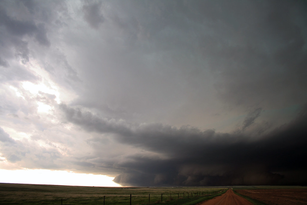
I'm glad the eastern TX panhandle is big-sky country, because the road network in that area is terrible. I managed to find a dirt road that went west of Canadian for many miles. I was worried about getting cored if I went too far north. When I initially arrived on the storm it had begun to sink south very slowly. After 30 minutes I could tell it had wobbled back north. The wall cloud persisted, but I saw no further lowering nor any increased rotation. Eventually seeing some sort of wrap going on to the north, and seeing the storm simply not press south, I decided to go back to town and go north. On the way I noted the cloud base on the southern edge of the RFD/gust front region had noticeable anticyclonic rotation, but no lowerings.

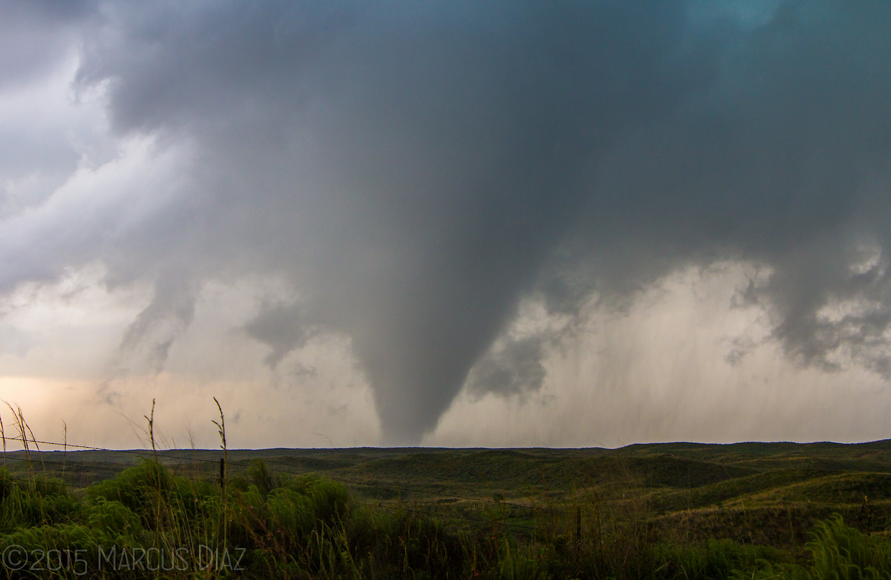
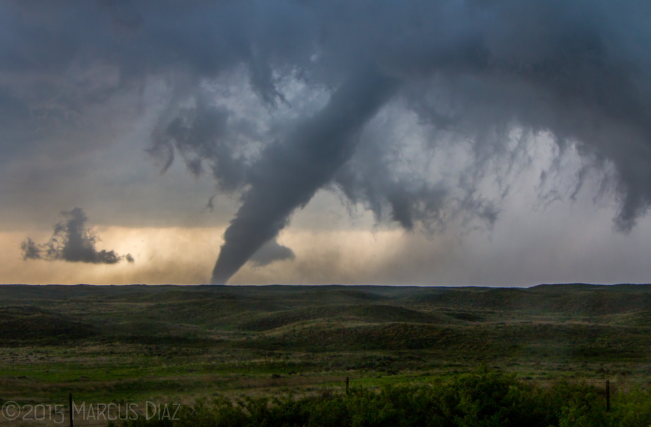
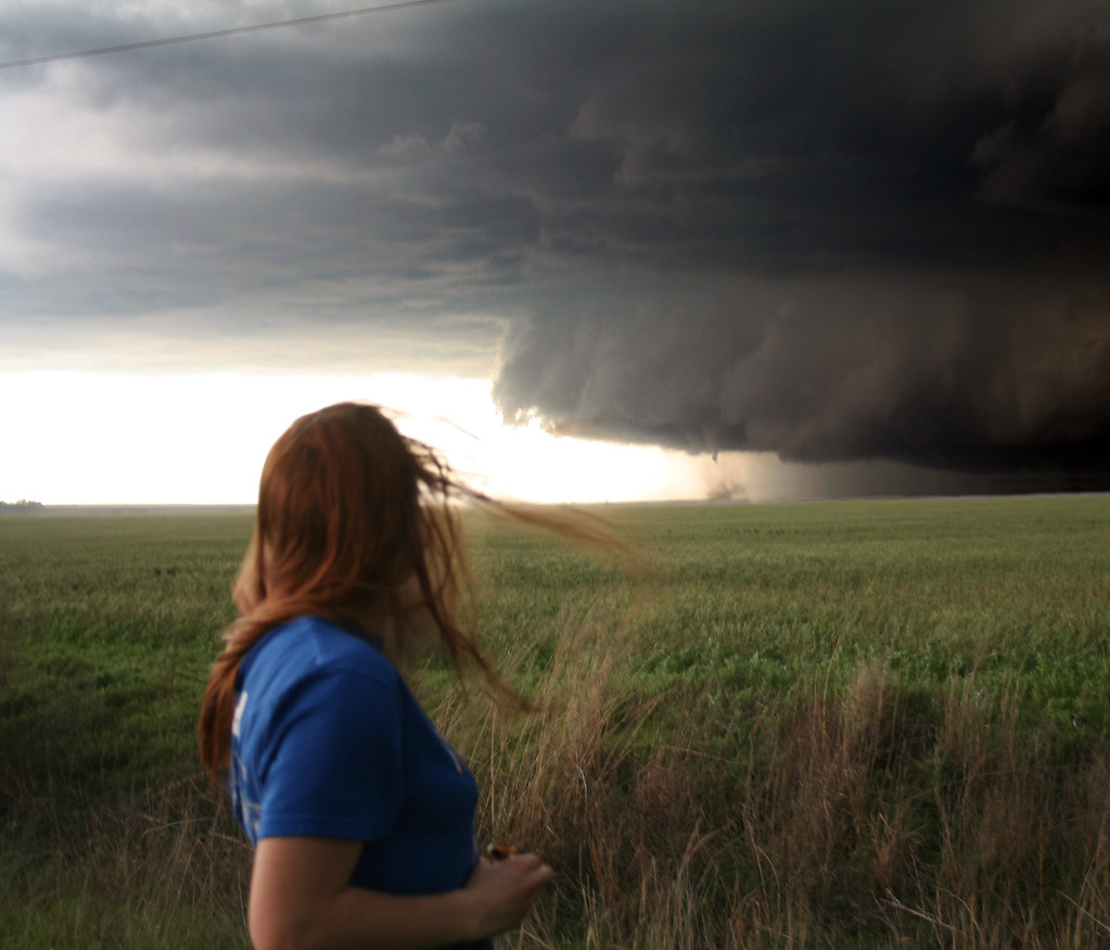
I stopped a few miles north of Canadian on U.S. 60, perched on a high spot looking west for a long time. I decided I would sit there as long as the core didn't overtake me or as long as big hail didn't start to fall. Neither happened. In fact, I was able to sit there through the entire big tornado that formed. It honestly surprised me. The RFD pushes that led up to it were fairly cold and really lifted the cloud base. That was probably one of the largest RFD regions I had ever been inside. I could clearly see the southern edge of the wrap pass many miles south of me without actually hitting me. I noted the pretty broad lowering off to the west with extended cloud tags preceding tornadogenesis, and it was fun being able to look up at a steep angle into the void left by the RFD above, but it didn't look like a tornado was going to be imminent. I was thinking about moving south when I looked out my window and saw the funnel almost to the ground.

Seldom in my chasing career have I had 1) the opportunity to comprehensively document a tornado (almost always caused by meteorological or logistical problems); and 2) actually taken advantage of such opportunities. I managed to snap off about 50 solid pics of the tornado while also remembering to adjust my windshield-mounted video camera inside the car. I made a brief movement north after the tornado started because I thought it might move off to the east/northeast, and I wanted to stay in the path for best contrast. So I missed a minute or two of video of it while moving, but caught all the rest. If only there hadn't been so many random spits of heavy rain while the tornado occurred, I probably would've gotten even better shots. I happened to be parked near Greg McLaughlin during this sequence, so I shook his hand while we each shouted with joy. We observed a single tumbleweed get blown east across the highway, then a few minutes later get blown back west. We also started to notice a newly formed rotating wall cloud less than a mile to our east. In fact, after the main tornado finally died, I only moved back south a bit because the west edge of the wall cloud had shifted over my head.

If only that next wall cloud had produced...I would've had a front row seat for that one. As with many of the wall clouds/low-level mesos on this storm, it slowly moved southwest. Given the stationary nature of the entire storm, however, that doesn't surprise me too much.

That wall cloud fizzled but was soon after replaced by another one in almost the same spot. Seeing other large wall clouds already present back to the southwest, I went all the way up to F.M. 1920 to position myself at a good angle catch two possibly tornadic wall clouds simultaneously. It eventually became clear to me that the near wall cloud was not going to produce either. With the core looking to move in, I fled back south to the south end of town where I spent pretty much the remainder of the chase, perched on a high spot off of U.S. 60/83.

At that point it appeared the entire town had just stopped. Traffic was just insane, and it wasn't all chasers at that point. There were a lot of 18-wheelers going through town throughout the chase. Presumably they had a lot of commerce in the area (and only one big highway through town). Areas south of town were disgustingly crowded with spotters/chasers/locals. For example, when I first got to town early in the chase, I was able to find a spot to park on Exhibition Rd. with only one or two other chasers nearby. By the time I came back to that road, there was literally no room for any more cars to park along it, and barely enough room to drive. The spot I settled on about 1/4 mile north was initially almost empty, but I was boxed in within 15 minutes. It's a good thing I was never compelled to try to move.

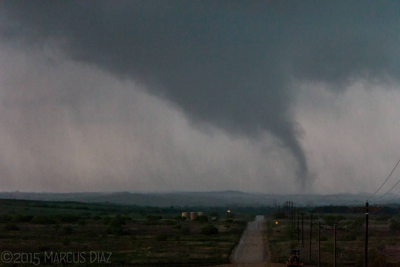
I witnessed the final few tornadoes from that spot, although the contrast wasn't great (because of distance and looking into the core). I tried to adjust between shooting the short-lived funnels that continually emerged from random circulations at the cloud base and occasional CG barrages. David Reimer and Paige Burress were right next to me and had more success with that than I did. I never managed to capture a single CG, although random inflow wind did blow my tripod over and slightly damage my camera. Oh well. Not the first time my D40 has taken a hit. It still works just fine!

After the final tornado I decided to core punch to see if anything was going on in there. I went up on F.M. 1920 again, this time several miles. I passed by a low spot where it looked very close to becoming submerged in water, so I knew I couldn't stay there for long. Visibility also dropped quite a bit, so I turned back, getting blasted by several close CGs. The storm was disorganizing, but I still managed not to experience any hail at all.

150527_042.JPG
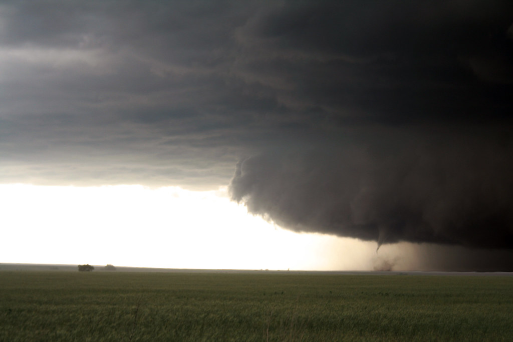
Above: looking into the void as an RFD punches through

150527_043.JPG
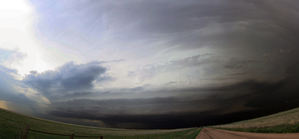
Above: the scuddy low-level meso a minute prior to tornadogenesis.

150527_048.JPG
Above: I like how you can see the edge of the tornado going all the way up into the mesocyclone well above the cloud base. I saw something similar with the La Grange, WY tornado in 2010.

150527_059.JPG
Above: the tornado becomes somewhat dusty/wispy looking.

150527_079.JPG
Above: tornado roping.

150527_212.JPG
Above: my view of the final tornado. I tried to tinker with the contrast, but it's best seen when looking uncompressed. Not great contrast.
 
Last edited:
I arrived in Canadian around 3:45 or so and pretty much spent the next 4 hours along with everyone else. I went slightly north of town and got a few photos of the hail core up close, since it was moving about 1 inch per hour. Before the tornado produced I dropped to the southeast away from the crowds on a little back road and got a great view. It was an amazing day. 95% spectating, 5% chasing.

9f9d9ea5f8304dd9f905687a4d224d24.jpg

99f7c18b29b6093137f1769c1b852662.jpg

99f803d1330939f312684374a9392ece.jpg
 
Video clips from Wednesday's chase:


I left Norman around 11:30am, took I-40 to Elk City and then OK-152/TX-152 to Wheeler, then shot N to Canadian and arrived on the storm just as its first low-level mesocyclone began ramping up. It wasn't long (~3:24pm CDT) before a gorgeous funnel descended beneath an absolutely textbook wall cloud and overall supercell structure; a far cry from the HPs we were all expecting, no doubt. This would've been one of the most photogenic tornadoes I've seen, had it been able to persist for several minutes and condense fully to the ground.

6818d460ac7d2d2385a361e5a997b544.jpg

After this circulation wrapped in rain and occluded, the storm continued to look impressive for a short time. However, after 15 minutes or so, its appearance grew increasingly "cold" and failed to produce any more substantial wall clouds for well over an hour. At some point between 4-4:30pm, I started glancing at the Palo Duro area cells on radar and pondering my options, as the Canadian storm had seemingly become so outflow-dominant and decidedly unphotogenic. Thankfully, instead of bailing (a decision which no doubt would've been influenced by the suffocating hordes, slowing highway traffic under 40 mph for miles-long stretches), I simply repositioned from NW of town on US-83 to NE of town on US-60 for a more comprehensive view of structure -- and, by virtue of venturing into forward-flank hail, losing the crowd. It was around this time that I noticed a new low-level mesocyclone with impressive rotation, considering its broad appearance.

ebb7c388de6327faa39a1fa4e77634d2.jpg

This should've been my cue to blast SW, but the storm still seemed a bit "cold" for much more than brief spinups -- and boy, the view from this high point away from the ungodly hordes was hard to give up. A few minutes later, while casually examining radar, I looked back and noted a large stovepipe ongoing with moderate rain and hail clouding my view.

68a8d773850a4090f218a74f7aded309.jpg

Disgusted, I blasted back to US-60 in search of a spot where powerlines weren't near-level with the road; I quickly gave that up and decided scrambling down the ravine to get below them was preferable in the circumstances. From there, I watched and photographed the final 6-7 minutes of the EF2's life cycle.

2d3c19a32f78e24b37b7dae45f141bbc.jpg

7e8109d5be9bf420bbe3e5f096a56463.jpg

Immediately after the (spectacular) ropeout, I became awestruck by what I presume is the same ominous low-level mesocyclone nearly overhead which Jeff Duda mentioned in his account. Given how much the previous tornado exceeded and reoriented my expectations for the day, I was ready for an Allison 1995 repeat to unfold less than a mile from me beneath this beast. While that didn't come to pass, it was quite a site to behold in its own right.

c7d0869b93b8029e11e791cc32b64b48.jpg

After this circulation weakened, I headed back W for yet another new one around the same area the first of the day had formed, well NW of town. For about half an hour, it continuously looked like tornadogenesis was plausible within a matter of minutes, but could never quite wrap up and get the job done. Eventually, I took the opportunity to get back through town and get W on Co. Rd. 1 for a higher view more removed from the precip. This paid off when I was able to photograph the intermittent cone around 6:01-6:05pm without any terrain obstructions, a first for the day.

a2213c26d57399c672d92da1f53236c3.jpg

Overall, a Panhandle Magical chase day that will easily be one of the best of the year. I will say it could've been an absolute career-making type of day had it occurred in areas only 15-20 mi. away with more manageable terrain and road options. I can't imagine a much better experience than safely intercepting the Canadian EF2 from close range on good roads, as it was almost stationary and (unlike even Bennington) not rain-wrapped at all for its duration. Alas, we'll have to settle for the still-awesome show we got.
 
Here's my two videos from this day. The first is of the large tornado north of Canadian. The video was plagued by wind noise, so I decided just to throw some ambient music to it instead. The second video is of tornadoes 2, 3, and 4 west of Canadian. I had better luck with the wind, so kept more natural sounds with them.


Here are the videos from my 2 dash cameras. I was a bit further away than most for main tornado, so it is a bit of a unique view. Powerlines were not a problem for me.

First is the wide-angled action camera, mostly timelapsed.

The other is my main video camera, also from the dash, but zoomed in for most parts.
 
Back
Top