• A friendly and periodic reminder of the rules we use for fostering high SNR and quality conversation and interaction at Stormtrack: Forum rules

    P.S. - Nothing specific happened to prompt this message! No one is in trouble, there are no flame wars in effect, nor any inappropriate conversation ongoing. This is being posted sitewide as a casual refresher.

2015-03-25 Reports TX/OK/AR/MO/IL/IN

STexan

EF4
I tracked to the south of the cell that ran up I-44 but it never ramped up for me. Bailed to watch a storm to the South at Sapulpa. That never ramped up. Managed to get into eastern Tulsa to catch the tail end of this significant storm that originated NW of Sand Springs.

As it got going again, it dropped the rain shroud. But I suspect most of the damage in eastern Tulsa was RFD wind damage. Haven't gone through my GoPro front view but there were plenty of transformers flares as I left and headed back south immediately behind this.

 
Last edited:
Summary: observed 2 or 3 different storms. Each tried to produce a tornado, but failed. Sampled only sub-severe hail. Some hectic moments on US 177 south of I-44.

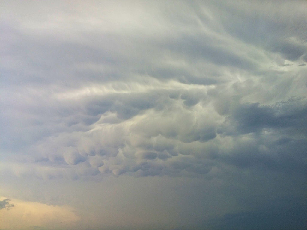
Full: Left Norman just after 3 PM with an initial target of Stillwater. By the time we got to Guthrie it was apparent the front was going to shove our play southward, so we went east on OK-33 towards Cushing. A storm pretty much developed right on top of us (actually just north of 33) as we were near Perkins. Before there was even 40 dBZ on that storm, moderate cloud base rotation was visible, despite the high base and lack of precip core. It was impressive to see, especially since we were almost right under it. That storm tried to produce a tornado at least one or two other times later on. As we headed north on OK-108 near Ripley, the storm made a good strong attempt at tornadoing - there was moderate-to-strong upward motion with vapor strands going right into the mesocyclone (there wasn't much of a wall cloud with it). A solid RFD push gusted it out shortly after tornadogenesis failed. The RFD air was pleasantly warm and moist, but that didn't matter on this day. The storm strongly weakened after that (just as the storm just west of Tulsa was starting to go crazy). We popped out on OK-18 north of Cushing where we decided to head back southwest towards new storms firing just NE of OKC.

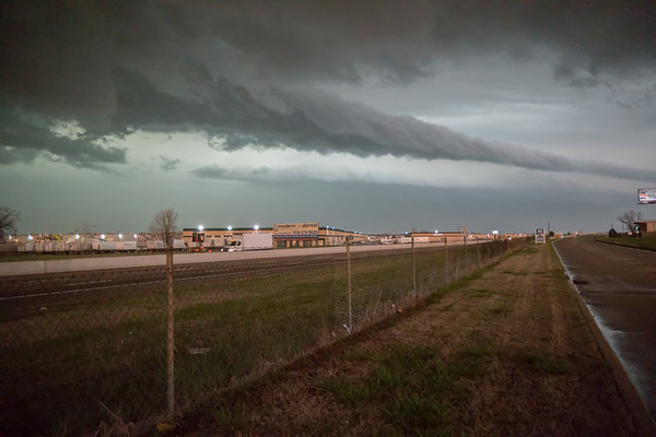
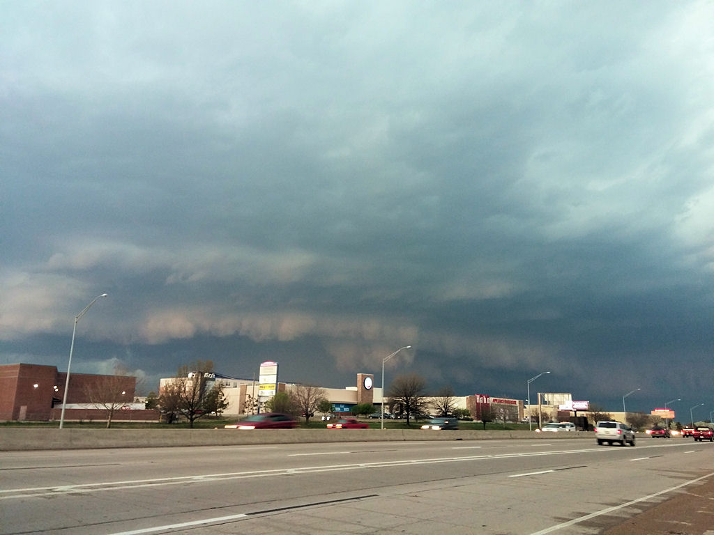
We made it to Chandler, then headed west to US-177 near I-44, where we witnessed our second storm with surprisingly decent supercell structure. It even had a somewhat persistent skinny lowering (puny excuse for a wall cloud perhaps) under a rather high base. We went back and forth on US-177 between there and Carney trying to decide if it was worth it to core punch. By this point the storm was losing its identity and the cores were starting to form, mature, and die out in rapid sequence, leaving it difficult for us to get to a core before it weakened. After noting a lot of violent and turbulent motion southeast of the core (over the RFD/FFD gust front) and a lack of organization back in the precip, we went back south. We were going to go west on 66 to go back to Norman, but a new and absolutely nasty looking core had developed over the road. It was some of the darkest overall light and some of the most saturated teal hue I have ever seen. Decided against potentially getting very large hail and went south on US-177 to get around it.

The next 12 or so road miles were a mix of frantic driving and brief stops to see an absolutely mean looking dark green core chomping up the road behind us as we pushed south. We were straddling the gust front the entire time, so we would switch between NW and S winds. At one point the horizontal vorticity along what was really the shelf cloud at that point was among the most impressive I had ever seen. One end of it looked to be tilting into the vertical to our immediate southwest, so we figured it was time to bail. We pretty much collided with whatever it was (probably a gustnado) as a large spray of dust and very strong winds went over us just a mile or so down the road. Also at some point along this I glanced at my phone's radar and back to the road to see some moron driving at full speed the wrong way on the shoulder on OUR side of the road...AND with their headlights off!!! That's exactly how Andy G. got killed (RIP, Andy). It bothers me to see that kind of ridiculous behavior in a situation like this. In general there were way too many people driving around without their lights on during a time in which it was almost as dark as night under the storm. I don't normally harp on things like that, but this was clearly a situation in which headlights were necessary for safe driving around storms.

Anyway, we went all the way down to Shawnee to OK-9 to avoid the storms coming east out of OKC. We saw some white dust column while driving west on 9 west of Tecumseh at some point. It persisted for a few minutes, but it was distant and the low light made it difficult to discern. Could've just been an outflow surge, but it could've been a gustnado, too. There wasn't really much obvious structure above it, so I doubt it was anything tornadic.

Overall an enjoyable chase given the environment and the expectations. It felt great getting out there for the first time this year.

Addendum: Since 13 April 2012 I have now missed four tornadoes that struck Norman or Moore while I was out chasing. My personal tornado drought is now at 675 days (last tornado: 19 May 2013 in Kansas).
 
Left the Storm Prediction Center around 6:30 heading home to Shawnee. As I was driving east on Highway 9, I noticed well-defined mammatus clouds overhead stretching toward the northwest. As I kept looking to the northwest I saw what I now know was the Moore tornado: a rounded, white cone. As I drove off into the trees, I wasn't able to keep up visually with the tornado.

So unplanned chase results in yet another tornado I have seen within a mile of the SPC. And the streak of years with at least one tornado/gustnado visible from the NWC continues (2008-2015).
 
Rolled out of Norman at 3 on the nose with an initial target of Minco. Ended up swinging through Chickasha and stopping just a bit past Pocasset on US 81 as the front advanced and starting agitating Cu to our immediate W/NW. Full blow CI got under way as we traipsed west from Pocasset on CO Rd. 1260 into Gracemont. Saw excellent, semi-discrete supercell structure with a large, linear gust front immediately to our north further up US 281. Sat just off 281 for awhile watching the storm spin with a few weak attempts to get a lowering going. Noted mid-level rotation with decent helical, laminar bands going around the stacked plates in the mid-levels. Then dropped south as the front slowly pushed it SE and got more next to the Delaware Nation HQ. Saw some great ouflow motion and a pretty sizeable gustnado before cutting through Anadarko and encountering strong outflow yet again. Moved back east on US 62/OK 9 with high-based, turbulent motion overhead. Saw one more attempt at a wall cloud that was ingesting obviously well-mixed, ML parcels just west of Chickasha before playing in the hail a bit in town and finishing up at Dairy Queen. The lightning on the way back to Norman wasn't too shabby either. All in all, a great chase day even though the storm failed to produce (also wtf at that northern storm modifying the front and producing?).

19789_980142175344456_8481064970123996153_n.jpg


19382_980142182011122_2988309933309503204_n.jpg


11070187_980142382011102_3848788314474997493_n.jpg


10984502_980142532011087_6945497796789306623_n.jpg


21172_980142815344392_2344011733735756577_n.jpg
 
Left the Storm Prediction Center around 6:30 heading home to Shawnee. As I was driving east on Highway 9, I noticed well-defined mammatus clouds overhead stretching toward the northwest. As I kept looking to the northwest I saw what I now know was the Moore tornado: a rounded, white cone. As I drove off into the trees, I wasn't able to keep up visually with the tornado.

So unplanned chase results in yet another tornado I have seen within a mile of the SPC. And the streak of years with at least one tornado/gustnado visible from the NWC continues (2008-2015).


I saw the same funnel from WDT across the street. And, that is quite an impressive streak!

33u352e.jpg

w71jqc.jpg
 
Caught this tail NE of Tulsa. Camera looking north.


As I side note. Was somewhat surprised to see a Southwest jet landing to the north right as this meso was passing through Tulsa. Wow what a ride that must of been
 
Last edited:
I intercepted the cell moving east across north Tulsa, after it had produced the Sand Springs tornado. The meso/wall cloud was clearly visible to the west from my work in west Catoosa as I was leaving about 6 pm. Tried to get south of the meso for a good viewing spot, but I was on its southern edge as it arrived near 21st street and E 145th (the old Eastgate Mall). There I encountered brief small hail and strong gusty winds, and observed what could have been wrapping rain curtains just to the south. I saw nothing further of note after that. Later on the local news a camera crew showed hail covering the ground in Catoosa.
 
I left Houston area around 5:30 am Wednesday morning and met up with some friends in Norman around midday. I watched the initial storms go up northeast of OKC but made the wrong call and decided to wait for later development along the front. Ended up heading west to near Anadarko and intercepted the western most storm. It wasn't long before the front undercut everything out west and I just settled for some iphone panoramic shots. 032515Aa.jpg 032515bd.jpg
 
I intercepted the cell moving east across north Tulsa, after it had produced the Sand Springs tornado. The meso/wall cloud was clearly visible to the west from my work in west Catoosa as I was leaving about 6 pm. Tried to get south of the meso for a good viewing spot, but I was on its southern edge as it arrived near 21st street and E 145th (the old Eastgate Mall). There I encountered brief small hail and strong gusty winds, and observed what could have been wrapping rain curtains just to the south. I saw nothing further of note after that. Later on the local news a camera crew showed hail covering the ground in Catoosa.

We had started on the southern most cell near Kellyville on route 66. It was fading as the cell to the north near Cleveland ramped up. We hit mostly nickel size hail with a couple of golf balls dropping as we headed east on 66 then onto the Turner. Once we passed the turnpike gates it was mostly pea size. The hail stayed with us until we hit 244 where it merged onto 75.
We headed north on 75 to catch the Cleveland storm as it moved near Skiatook. We had plenty of time to get into position as we exited onto Highway 20 from 75 north. It was the the storm made a right turn, actually going SE for a bit. we headed back down 75 and stopped near highway 11 as the storm headed into Sand Springs. We had a good view looking WSW into the cell but it became rain wrapped before we could see the funnel.

We headed east on 11 to 244 and noticed areas of rotation to our NW and SW a little after 1800. As we passed 89th street our vehicle was hit from the south by a 40-45MPH gust that sandblasted those on the passenger sides. A moment later the vehicle rocked hard with a gust from the north closer to 70-75MPH and blew in the drivers side window. There was a significant amount of debris in the air at least to 100 feet. We bailed onto Mingo and ended up stopping at a Pizza Hut nearby and watched a couple more areas of rotation come through with some intense lightning, gusty winds, and small hail.

I'm pretty certain we were hit by a gustnado but it was pretty dang intense for a few minutes regardless.

Unfortunately, we didn't get many good pics.
The GR images are at 244 west of 169 where we got blasted. The mammatus were at about 126th St N and hwy 75.
Another from highway 11 and highway 75.
the last one was over near 21st and Mingo in Tulsa.

_kinx_20150325_1802_Vel_Top.png _kinx_20150325_1807_Rot_S_Side_.png 18620_10202768189124635_4980338494328617228_n.jpg 997039_10202768188004607_8830799450470814803_n.jpg 10986636_10202768187764601_1484924901076496383_n.jpg 11014811_10202768188204612_171226945576453475_n.jpg
 
I started out the day near Minco and drifted to the north, getting antsy along the way since tornadoes had already been reported in Sand Springs and development was just underway further out west than my liking. HRRR was spot on with initiation out west but I was hoping to jump on a cell between before everything lined out. I stopped in El Reno for just a bit then worked my way up near Piedmont where a small cell had formed alone, but it sped off to the northeast and I couldn't keep up. By this time the western cell had moved to the west of El Reno, so I sped down to meet it head on and ended up catching along Route 66 between Yukon and El Reno where I got this shot:

25swlz7.jpg


I then moved back into Yukon and decided to ride it out, hail core and all until it passed because I didn't think I could stay in front of it in OKC and didn't want to get stuck in traffic when it moved through. My driver's side mirror was broken by the hail.

Just before the hail hit:

e7b9lw.jpg


Riding out the hail and rain:

 
Target area was Guthrie OK coming from Nebraska. Saw towers going up in the area around 230-300pm. Chased east after them. Nice elevated updrafts. Saw what possibly could of been sheer funnels. Got a nice timplapse east of Drumright.Was behind the cells all the way to Sapulpa OK. Saw some nice mammatus around the same area. Noticed rotation on radar NW of Mannford and mins. later tornado warning came out. Didn't get visual of tornado until South Sand Springs. The power was out and it was quite chaotic traffic trying to escape south. First time in metro area and tornado close by. Not so fun. Nevertheless it was a good chase. Glad we made the trip.


Left work at 3:30 PM and loaded all my gear up, was chasing alone and didn't plan on being very aggressive. Headed south on US HWY 75 from Bartlesville and waited for the storm to move in from the west. Once it became tornado warned I headed south on 75 and then further south from HWY 11 to 169. Kept a watch on the storm as it moved across Tulsa from 169.

Shot this photo east of US HWY 75 and 86th St North, looking west.

7WWmGCX.jpg


Looking northwest on HWY 169 in Tulsa.
Ki0hddJ.jpg
 
Last edited:
I had targeted NE Oklahoma based on progged warm front location that afternoon, plus it is my home area and I like to stay close just in case. Went for the southern cell in Creek County headed for Tulsa, but as I watched it die and the storm in Osage Co. ramped up. I headed through nightmarish traffic and was 10-15 minutes late for the Sand Springs tornado. We sat up near downtown Tulsa with basically zero escape options due to traffic and parked up close to a building (not very wise choice but better than out in the open) and rode the storm out. Experienced 80-90 mph winds and shot damage footage after it blew through. Did manage to snap a couple of pics of the meso approaching downtown. uploadfromtaptalk1427463206987.png
 
My original plan to play the dryline for some possible isolated supercells was spoiled by the lack of sufficient dewpoints in that area. With a 30 degree dewpoint depression, I didn't bother messing around with it, so I went north toward OKC a bit reluctantly to play the cold front storms. That turned out to be a great decision! Made it all the way up to Chickasha and saw some great structure, then went and played in the hail for a while, getting into stones as big as ping pong balls. Full account is posted on my blog.

Chickasha Storm-2.jpg
 
My target was the dryline the whole setup and I sat in southwest OK sunning. A storm tried to go up multiple times near Wichita Falls, but it was never able to sustain an updraft and visually I never could see it.

Ended up getting some great shelf cloud pictures near Maysville, OK and night shelf/lightning pics in the Arbuckles.

The full chase recap and all my photos are posted at http://www.benholcomb.com/chases/20150325

20150325-20150325-img_1004_-_20150326-img_1008.jpg


20150325-20150325-img_0928_-_20150325-img_0931.jpg


20150326-img_1108.jpg
 
Hello all I wanted to share some pictures of the Moore Storm that happened March 25. First off it was a suprise storm that nobody was expecting. My chase partner Nicholas Hoad was driving. At first our original plan was to go as far as Chikissha but as soon as we got there he told me to look at the radar and see what the storm was doing. We then decided to go into moore and to chase this storm. Enjoy the pictures. The storm was intense throwing tennis size hail. I will be having video up in a couple of days.
10676291_829458113813856_253026692577797269_n.jpg


11083662_829458537147147_5784941658777870231_n.jpg

13182_829458663813801_1933793132287516865_n.jpg

If you look carefully on the middle right of the picture you will see the windcups missing from the weathernet truck we had only one issues with the equipment and it was the fact that the bolt that held the wind cups on the axel wasnt fully seated and it worked its way out and we lost them
10653682_829458443813823_7412913934785446799_n.jpg

1546141_829458800480454_4642900069388296883_n.jpg

This was our visibility on the I 35 we did encounter the tornado how ever when we did we where well out of the way of it. The NWS did fail to call it a tornado even thought power went out and there was multiple chasers on it stating the same thing. These are only a couple of the pictures i took and still have alot to go through the footage should be up in a couple of days thank you for taking the time looking though my chase cant wait to read what you all think.
Forum:
 
Back
Top